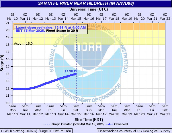
Santa Fe River near Hildreth (in NAVD88)
Critical Stages
18' - Action
20' - Flood
26' - Moderate
28' - Major
Latest Observation
Updated: 12:00 PM EST 12/16/25
Status: Low Threshold
Stage: 6.25 ft
Flow: -999 kcfs
Forecast
Forecast not available for this location.
| Time | Stage (ft) | Flow (kcfs) |
|---|---|---|
| 12:00 PM 12/16 | 6.25 | -999 |
| 11:45 AM 12/16 | 6.25 | -999 |
| 11:30 AM 12/16 | 6.26 | -999 |
| 11:15 AM 12/16 | 6.26 | -999 |
| 11:00 AM 12/16 | 6.26 | -999 |
| 10:45 AM 12/16 | 6.26 | -999 |
| 10:30 AM 12/16 | 6.26 | -999 |
| 10:15 AM 12/16 | 6.26 | -999 |
| 10:00 AM 12/16 | 6.26 | -999 |
| 9:45 AM 12/16 | 6.26 | -999 |
| 9:30 AM 12/16 | 6.26 | -999 |
| 9:15 AM 12/16 | 6.26 | -999 |
| 9:00 AM 12/16 | 6.26 | -999 |
| 8:45 AM 12/16 | 6.26 | -999 |
| 8:30 AM 12/16 | 6.26 | -999 |
| 8:15 AM 12/16 | 6.26 | -999 |
| 8:00 AM 12/16 | 6.26 | -999 |
| 7:45 AM 12/16 | 6.26 | -999 |
| 7:30 AM 12/16 | 6.26 | -999 |
| 7:15 AM 12/16 | 6.26 | -999 |
| 7:00 AM 12/16 | 6.26 | -999 |
| 6:45 AM 12/16 | 6.26 | -999 |
| 6:30 AM 12/16 | 6.26 | -999 |
| 6:15 AM 12/16 | 6.26 | -999 |
| 6:00 AM 12/16 | 6.26 | -999 |
| 5:45 AM 12/16 | 6.26 | -999 |
| 5:30 AM 12/16 | 6.26 | -999 |
| 5:15 AM 12/16 | 6.26 | -999 |
| 5:00 AM 12/16 | 6.26 | -999 |
| 4:45 AM 12/16 | 6.26 | -999 |
35.6' -
Water reaches the top of the US 129 bridge railing.
32.2' -
Water begins to flood the US 129 bridge travel lanes.
32' -
Water reaches the approach roadway surface of the US 129 bridge.
31' -
In Suwannee County, 296th Street floods just west of US 129. An abandoned country store a quarter mile north of the bridge floods at this level.
30' -
In Suwannee County, homes south of River Run Road west of 45th Road are surrounded by water. Significant flooding occurs at Sandy Point. Most buildings south of the entrance are flooded at or above this level.
29' -
In Gilchrist County, significant flooding occurs at Ellie Ray's Resort at the end of NW 110th Street. Nearly all slots are flooded and the recreational building and pool are flooded. Access into the area is restricted west of NW 31st Way.
28.4' -
Water reaches the base of the US 129 bridge.
28' -
At Sandy Point in Suwannee County, the restaurant is surrounded by water and flooding expands further across the campgrounds.
27' -
In Suwannee County, access to River Run Road west of 45th Road becomes restricted above this level.
26' -
Ellie Ray's Resort at the end of NW 110th Street in Gilchrist County continues to flood. Water approaches the pool and several RV slots.
25' -
Water floods the backyards of homes off River Run Road in Suwannee County.
22' -
Water reaches the top of the bank and boat ramp at Ellie Ray's Resort at the end of NW 110th Street in Gilchrist County.
20' -
The campgrounds at Sandy Point in Suwannee County begin to flood. Water floods the parking area on the east side of Sandy Point.
18' -
Boat ramps begin to flood along the Santa Fe River from the confluence with the Suwannee River upstream to River Run Road in Suwannee County.
| Date | Stage (ft) |
|---|---|
| Apr 12, 1948 | 33.41 |
| Apr 19, 1973 | 29.97 |
| Mar 24, 1998 | 28.75 |
| Mar 25, 1948 | 28.05 |
| Mar 27, 1959 | 27.22 |
| Feb 25, 1986 | 26.76 |
| Mar 1, 1998 | 26.75 |
| Mar 18, 1991 | 26.44 |
| Sep 19, 1964 | 26.29 |
| Nov 26, 1947 | 26.11 |
| Apr 17, 2009 | 25.83 |
| Apr 17, 2005 | 25.8 |
| Oct 12, 2004 | 25.65 |
| Dec 31, 1947 | 25.6 |
| May 2, 2014 | 24.6 |
| Mar 14, 1965 | 24.37 |
| Mar 14, 1987 | 23.96 |
| Feb 12, 1991 | 23.89 |
| Mar 17, 1964 | 23.85 |
| Mar 28, 1965 | 23.8 |
Data provided by the National Weather Service.