Santa Fe River near Fort White (in NAVD88)
Critical Stages
22' - Action
23' - Flood
25' - Moderate
29' - Major
Latest Observation
Updated: 12:45 PM EST 12/16/25
Status: Low Threshold
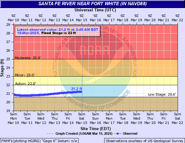
Stage: 20.18 ft
Flow: -999 kcfs
Forecast
Forecast not available for this location.
| Time | Stage (ft) | Flow (kcfs) |
|---|---|---|
| 12:45 PM 12/16 | 20.18 | -999 |
| 12:30 PM 12/16 | 20.18 | -999 |
| 12:15 PM 12/16 | 20.18 | -999 |
| 12:00 PM 12/16 | 20.18 | -999 |
| 11:45 AM 12/16 | 20.17 | -999 |
| 11:30 AM 12/16 | 20.17 | -999 |
| 11:15 AM 12/16 | 20.17 | -999 |
| 11:00 AM 12/16 | 20.18 | -999 |
| 10:45 AM 12/16 | 20.18 | -999 |
| 10:30 AM 12/16 | 20.18 | -999 |
| 10:15 AM 12/16 | 20.17 | -999 |
| 10:00 AM 12/16 | 20.17 | -999 |
| 9:45 AM 12/16 | 20.17 | -999 |
| 9:30 AM 12/16 | 20.17 | -999 |
| 9:15 AM 12/16 | 20.17 | -999 |
| 9:00 AM 12/16 | 20.17 | -999 |
| 8:45 AM 12/16 | 20.17 | -999 |
| 8:30 AM 12/16 | 20.17 | -999 |
| 8:15 AM 12/16 | 20.17 | -999 |
| 8:00 AM 12/16 | 20.17 | -999 |
| 7:45 AM 12/16 | 20.17 | -999 |
| 7:30 AM 12/16 | 20.17 | -999 |
| 7:15 AM 12/16 | 20.17 | -999 |
| 7:00 AM 12/16 | 20.17 | -999 |
| 6:45 AM 12/16 | 20.17 | -999 |
| 6:30 AM 12/16 | 20.17 | -999 |
| 6:15 AM 12/16 | 20.17 | -999 |
| 6:00 AM 12/16 | 20.17 | -999 |
| 5:45 AM 12/16 | 20.17 | -999 |
| 5:30 AM 12/16 | 20.17 | -999 |
40' -
Water reaches the top of the SR 47 bridge railing.
38' -
Water begins to flood the SR 47 bridge travel lanes.
35' -
Water reaches the base of the SR 47 bridge.
31.5' -
Water reaches the approach roadway surface to the SR 47 bridge.
29' -
Major damage and disruption to the community is expected. Roads will be cut off and many homes will be surrounded by water. Boat wash damage to homes will be severe.
25' -
Damage to homes at low elevation as well as basement areas underneath homes on stilts is likely.
23.25' -
Florida Fish and Wildlife Commission begins enforcement of a no wake zone on the Santa Fe River from the centerline of the US 27 Bridge downstream to one-half mile upstream from the State Road 47 Bridge.
23' -
Minor damage to dwellings is possible due to boat wash.
| Date | Stage (ft) |
|---|---|
| Sep 16, 1964 | 35.4 |
| Sep 15, 2017 | 34.46 |
| Apr 12, 1948 | 33.76 |
| Mar 15, 1948 | 32.61 |
| Feb 26, 1998 | 32.21 |
| Jun 30, 2012 | 31.45 |
| Jun 20, 1934 | 31.1 |
| Oct 8, 1992 | 30.58 |
| Mar 24, 1959 | 30.41 |
| Apr 19, 1973 | 30.32 |
| Mar 24, 1998 | 30.2 |
| Sep 12, 2004 | 29.65 |
| Aug 27, 1928 | 29.56 |
| Oct 24, 1944 | 29.54 |
| Apr 11, 1984 | 29.49 |
| Apr 3, 1970 | 29.3 |
| Oct 1, 2004 | 28.94 |
| Sep 24, 1928 | 28.86 |
| Sep 28, 1947 | 28.79 |
| Oct 9, 1928 | 28.46 |
Data provided by the National Weather Service.