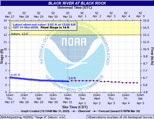
Black River at Black Rock
Critical Stages
12' - Action
14' - Flood
25' - Moderate
28' - Major
Latest Observation
Updated: 7:00 PM CST 12/9/25
Status: No Flooding
Stage: 2.95 ft
Flow: 3.96 kcfs
Forecast
| Time | Stage (ft) | Flow (kcfs) |
|---|---|---|
| 12 AM 12/10 | 2.9 | 3.92 |
| 6 AM 12/10 | 2.9 | 3.92 |
| 12 PM 12/10 | 2.8 | 3.84 |
| 6 PM 12/10 | 2.8 | 3.84 |
| 12 AM 12/11 | 2.8 | 3.84 |
| 6 AM 12/11 | 2.8 | 3.84 |
| 12 PM 12/11 | 2.8 | 3.84 |
| 6 PM 12/11 | 2.7 | 3.75 |
| 12 AM 12/12 | 2.7 | 3.75 |
| 6 AM 12/12 | 2.7 | 3.75 |
| 12 PM 12/12 | 2.7 | 3.75 |
| 6 PM 12/12 | 2.6 | 3.67 |
| 12 AM 12/13 | 2.6 | 3.67 |
| 6 AM 12/13 | 2.6 | 3.67 |
| 12 PM 12/13 | 2.6 | 3.67 |
| 6 PM 12/13 | 2.6 | 3.67 |
| 12 AM 12/14 | 2.5 | 3.59 |
| 6 AM 12/14 | 2.5 | 3.59 |
| Time | Stage (ft) | Flow (kcfs) |
|---|---|---|
| 7:00 PM 12/9 | 2.95 | 3.96 |
| 6:45 PM 12/9 | 2.95 | 3.96 |
| 6:30 PM 12/9 | 2.95 | 3.96 |
| 6:15 PM 12/9 | 2.96 | 3.97 |
| 6:00 PM 12/9 | 2.96 | 3.97 |
| 5:45 PM 12/9 | 2.93 | 3.94 |
| 5:30 PM 12/9 | 2.96 | 3.97 |
| 5:15 PM 12/9 | 2.95 | 3.96 |
| 5:00 PM 12/9 | 2.94 | 3.95 |
| 4:45 PM 12/9 | 2.95 | 3.96 |
| 4:30 PM 12/9 | 2.95 | 3.96 |
| 4:15 PM 12/9 | 2.96 | 3.97 |
| 4:00 PM 12/9 | 2.96 | 3.97 |
| 3:45 PM 12/9 | 2.97 | 3.97 |
| 3:30 PM 12/9 | 2.97 | 3.97 |
| 3:15 PM 12/9 | 2.97 | 3.97 |
| 3:00 PM 12/9 | 2.97 | 3.97 |
| 2:45 PM 12/9 | 2.96 | 3.97 |
| 2:30 PM 12/9 | 2.95 | 3.96 |
| 2:15 PM 12/9 | 2.97 | 3.97 |
| 2:00 PM 12/9 | 2.97 | 3.97 |
| 1:45 PM 12/9 | 2.97 | 3.97 |
| 1:30 PM 12/9 | 2.96 | 3.97 |
| 1:15 PM 12/9 | 2.97 | 3.97 |
| 1:00 PM 12/9 | 2.97 | 3.97 |
| 12:45 PM 12/9 | 2.97 | 3.97 |
| 12:30 PM 12/9 | 2.95 | 3.96 |
| 12:15 PM 12/9 | 2.97 | 3.97 |
| 12:00 PM 12/9 | 2.96 | 3.97 |
| 11:45 AM 12/9 | 2.97 | 3.97 |
32' -
The crest of record is 31.9 feet which occurred on August 21, 1915. Heavy rainfall was due to a hurricane which made landfall near Galveston Texas, and moved across Arkansas.
31.5' -
This is an extremely serious situation, residential areas of Black Rock, Portia, and Powhatan may be flooded. Flood crest of December 1982 was 31.51 feet, the second highest crest of record. Major flood damages to roads, bridges, and homes along the river in Lawrence, Jackson, and Independence counties. River is very dangerous at this level. State Highways 25, 37, and 69 will be flooded. Stay away from the edges of high banks along the river, bank caving is possible.
28.5' -
Highway 412 between Highway 63 and Walnut Ridge becomes inundated by flood waters.
28' -
Major flooding occurring at or above 28 feet. Portions of Black Rock and Powhatan Courthouse State Park floods. Jacksonport State Park Riverside of levee floods. State Highways 25, 37, and 69 will flood. 40 thousand acres of cropland flooded in Lawrence, Jackson, and Independence counties. Flood crests at Black Rock, 28.6 feet in April 2008, 29.7 feet in March 2008, and 30.45 feet in April 2011.
25' -
State Highway 37 will probably flood on west side of Black River. State Highway 25 south of Black Rock and State Highway 69 near Jacksonport may be partially flooded. Water will be in portions of Powhatan State Park. Extensive cropland flooding, flooding classified as moderate.
24' -
Thousands of acres of cropland and pastures flooded. State Highway 37 in Independence County east of Cord may be flooded. Water rises into low lying streets in Powhatan. Ball Park and Boat Ramp Area in Black Rock floods.
20' -
Agricultural land is flooding along both banks of the river in Lawrence, Independence, and Jackson counties. Minor flooding in Powhatan Community and Courthouse State Park.
17' -
Low lying cultivated land and pastures in Lawrence, Jackson, and Independence counties flood.
14' -
Minor flooding begins. Farm ground along east bank begins to flood.
| Date | Stage (ft) |
|---|---|
| Aug 21, 1915 | 31.9 |
| Dec 4, 1982 | 31.51 |
| Apr 27, 2011 | 30.45 |
| Apr 15, 1927 | 30.3 |
| May 1, 2017 | 30 |
| Mar 20, 2008 | 29.74 |
| Apr 6, 2025 | 29.74 |
| Apr 24, 1973 | 29.24 |
| Apr 12, 2008 | 28.61 |
| Jan 25, 1949 | 28.5 |
| Mar 29, 1977 | 28.1 |
| May 8, 1961 | 28 |
| Mar 29, 1975 | 27.9 |
| Mar 10, 1964 | 27.8 |
| Jan 31, 1969 | 27.72 |
| Oct 31, 2009 | 27.6 |
| Mar 31, 1945 | 27.2 |
| Dec 29, 2015 | 27.15 |
| Apr 5, 1957 | 26.9 |
| Jan 2, 1966 | 26.8 |
Data provided by the National Weather Service.