« Back to Jefferson County Rivers
Sugar River at Albany
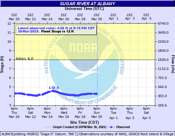
Critical Stages
8' - Action
12' - Flood
13' - Moderate
14' - Major
Latest Observation
Updated: 3:15 AM CST 12/8/25
Status: No Flooding
Stage: 4.09 ft
Flow: 0.341 kcfs
Forecast
Forecast not available for this location.
| Time | Stage (ft) | Flow (kcfs) |
|---|---|---|
| 3:15 AM 12/8 | 4.09 | 0.341 |
| 3:00 AM 12/8 | 4.09 | 0.341 |
| 2:45 AM 12/8 | 4.09 | 0.341 |
| 2:30 AM 12/8 | 4.09 | 0.341 |
| 2:15 AM 12/8 | 4.08 | 0.339 |
| 2:00 AM 12/8 | 4.08 | 0.339 |
| 1:45 AM 12/8 | 4.08 | 0.339 |
| 1:30 AM 12/8 | 4.07 | 0.337 |
| 1:15 AM 12/8 | 4.07 | 0.337 |
| 1:00 AM 12/8 | 4.07 | 0.337 |
| 12:45 AM 12/8 | 4.06 | 0.335 |
| 12:30 AM 12/8 | 4.06 | 0.335 |
| 12:15 AM 12/8 | 4.05 | 0.332 |
| 12:00 AM 12/8 | 4.05 | 0.332 |
| 11:45 PM 12/7 | 4.04 | 0.33 |
| 11:30 PM 12/7 | 4.03 | 0.328 |
| 11:15 PM 12/7 | 4.02 | 0.326 |
| 11:00 PM 12/7 | 4.02 | 0.326 |
| 10:45 PM 12/7 | 4.01 | 0.324 |
| 10:30 PM 12/7 | 4 | 0.322 |
| 10:15 PM 12/7 | 3.99 | 0.319 |
| 10:00 PM 12/7 | 3.98 | 0.315 |
| 9:45 PM 12/7 | 3.97 | 0.312 |
| 9:30 PM 12/7 | 3.96 | 0.309 |
| 9:15 PM 12/7 | 3.95 | 0.306 |
| 9:00 PM 12/7 | 3.94 | 0.302 |
| 8:45 PM 12/7 | 3.93 | 0.299 |
| 8:30 PM 12/7 | 3.92 | 0.296 |
| 8:15 PM 12/7 | 3.91 | 0.293 |
| 8:00 PM 12/7 | 3.9 | 0.29 |
13.8' -
Floodwaters cover a low spot on Highway EE near Wildlife Area about 2 miles north of Albany. Floodwaters get into the basements of some homes along South Water Street and in the basements of a few businesses on North Water Street in downtown Albany. Water backs up from storm drain and covers S Water Street. Floodwaters affect the back yards of a some homes along South Mill Street and S Water St. Floodwaters are into Village Park.
12' -
Floodwaters affect Village Park in Albany. Floodwaters cover parts of Tin Can Road about 2 miles northwest of Albany. Floodwaters are into the back yards of homes along South Mill Street and South Water Street in Albany.
11' -
American Legion Park and N Water St into park is flooded.
10' -
Floodwaters cover Tin Can Road about 2 miles northwest of Albany. There is widespread lowland flooding in the Albany area.
9.75' -
Floodwaters affect parts of Tin Can Road about 2 miles northwest of Albany. There is widespread lowland flooding the Albany area.
8.5' -
There is widespeard lowland flooding in the Albany area. Floodwaters cover parts of Tin Can Road about 2 miles northwest of Albany.
8' -
There is minor lowland flooding in the Albany area.
| Date | Stage (ft) |
|---|---|
| Feb 21, 2018 | 13.88 |
| Mar 15, 2019 | 13.73 |
| Aug 23, 2018 | 12.91 |
| Jun 27, 2013 | 12.16 |
| Aug 21, 2007 | 12.07 |
| Jul 23, 2017 | 12.04 |
| May 24, 2004 | 11.35 |
| Aug 8, 2007 | 10.11 |
| Mar 26, 2009 | 9.81 |
| Jan 24, 2018 | 9.35 |
| Apr 28, 2009 | 9.06 |
| Mar 14, 2007 | 8.78 |
| Jan 23, 2017 | 8.76 |
| Feb 11, 2009 | 8.73 |
| Apr 5, 2007 | 8.49 |
| Jun 22, 2014 | 8.49 |
| Apr 9, 2010 | 8.39 |
| Dec 16, 2015 | 7.71 |
| Mar 12, 2010 | 7.15 |
| Mar 23, 2011 | 6.93 |
Data provided by the National Weather Service.