« Back to Jefferson County Rivers
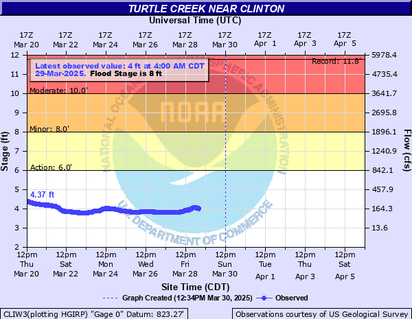
Turtle Creek near Clinton
Critical Stages
6' - Action
8' - Flood
11' - Moderate
12' - Major
Latest Observation
Updated: 4:00 AM CST 12/8/25
Status: No Flooding
Stage: 3.51 ft
Flow: 0.0452 kcfs
Forecast
Forecast not available for this location.
| Time | Stage (ft) | Flow (kcfs) |
|---|---|---|
| 4:00 AM 12/8 | 3.51 | 0.0452 |
| 3:45 AM 12/8 | 3.5 | 0.044 |
| 3:30 AM 12/8 | 3.5 | 0.044 |
| 3:15 AM 12/8 | 3.5 | 0.044 |
| 3:00 AM 12/8 | 3.51 | 0.0452 |
| 2:45 AM 12/8 | 3.52 | 0.0464 |
| 2:30 AM 12/8 | 3.53 | 0.0476 |
| 2:15 AM 12/8 | 3.54 | 0.0488 |
| 2:00 AM 12/8 | 3.56 | 0.0514 |
| 1:45 AM 12/8 | 3.59 | 0.0556 |
| 1:30 AM 12/8 | 3.62 | 0.0598 |
| 1:15 AM 12/8 | 3.59 | 0.0556 |
| 1:00 AM 12/8 | 3.6 | 0.057 |
| 12:45 AM 12/8 | 3.67 | 0.0672 |
| 12:30 AM 12/8 | 3.75 | 0.0801 |
| 12:15 AM 12/8 | 3.78 | 0.0853 |
| 12:00 AM 12/8 | 3.78 | 0.0853 |
| 11:45 PM 12/7 | 3.79 | 0.0872 |
| 11:30 PM 12/7 | 3.8 | 0.089 |
| 11:15 PM 12/7 | 3.78 | 0.0853 |
| 11:00 PM 12/7 | 3.76 | 0.0818 |
| 10:45 PM 12/7 | 3.76 | 0.0818 |
| 10:30 PM 12/7 | 3.75 | 0.0801 |
| 10:15 PM 12/7 | 3.74 | 0.0784 |
| 10:00 PM 12/7 | 3.73 | 0.0768 |
| 9:45 PM 12/7 | 3.72 | 0.0752 |
| 9:30 PM 12/7 | 3.73 | 0.0768 |
| 9:15 PM 12/7 | 3.73 | 0.0768 |
| 9:00 PM 12/7 | 3.74 | 0.0784 |
| 8:45 PM 12/7 | 3.75 | 0.0801 |
21' -
I 39 may be threatened north of Beloit. County BT / I 39 Alternate may be threatened north of Beloit.
20' -
Shopiere Rd may be threatened west of Shopiere and South Creek Rd may be threatened.
18' -
Multiple residences on Stonehenge Lane and Collingswood Dr threatened in Beloit. Residential structures may be threatened along Hawthorne Dr, Sarah Lane, and Ridge Rd in Beloit. Shopiere Rd may be threatened in Beloit.
16.5' -
Milwaukee Road / WI 81 threatened in Beloit.
16' -
Power substation inundated on Colley Road in Beloit.
15' -
Canterbury Drive threatened and multiple residential structures threatened in Leeson Park in Beloit.
14' -
Water into the backyards of homes on South Creek Rd near E Huebbe Pkwy. Water approaches South Creek Rd. Widespread inunation of roadways and structures in the floodplain reaches 3 blocks north of the creek in Beloit and 5 blocks south of the creek in South Beloit. Multiple residential structures threatened in Shopiere. Portions of South Beloit Municipal Park are inundated.
13' -
Multiple residences and businesses threatened along US 51 / Broad St, Park Ave, State St in downtown Beloit. Multiple residences and businesses threatened along US 51 / Gardner St, Blackhawk Blvd, Park Ave in downtown South Beloit. Water fills into the abandoned river channel along Philhower Rd north of Beloit, reaching the Rock River near US 51 / Riverside Dr. Residences surrounded by water along Moccasin Trail, Bootmaker Dr, Boulder Lane, Rockfence Lane in Beloit.
12' -
Colley Rd threatened in Beloit. Sarah Lane threatened east of Beloit. County J / Butterfly Rd threatened in Shopiere.
11.5' -
Water begins to flow across South Creek Rd into agricultural land north of Beloit and toward the abandoned river channel along Philhower Rd. Lathers Rd threatened in Shopiere. Moccasin Trail at Bootmaker Dr, Leeson Park and Leeson Park Rd threatened in Beloit. Widespread inundation of agricultural land from Beloit to Shopiere to Carvers Rock Park. Water overtops low-lying banks just downstream of Broad St in Beloit and just downstream of Blackhawk Blvd/State St in Beloit and South Beloit.
10' -
South Creek Rd threatened north of Inman Parkway east of Beloit. Low-lying private roadways threatened west of Shopiere. Yards of residential structures inundated along Mocassin Trail, Bootmaker Dr, East Ridge Rd, Boulder Lane, Rockfence Lane, and Arrowhead Rd in Beloit.
9' -
Smith Road threatened in Tiffany. Portions of Sweet Allyn Park in Shopiere inundated.
8.5' -
Portions of East Creek Rd threatened east of Tiffany. Parking lots threatened at Turtle Creek Parkway near Tiffany Stone Bridge. Widespread inundation of forest land north of Clinton and in the east side of Beloit.
8' -
Portions of the Turtle Creek Moccasin Trail inundated in Beloit.
7' -
Low-lying forest land and agricultural land inundated near Carvers Rock Rd and WI 140 north of Clinton. Low-lying forest land inundated upstream of Shopiere and near Broad St (US 51) in Beloit. Water overflows low-lying banks at Sweet Allyn Park in Shopiere.
5' -
Water overflows low-lying banks upstream of Milwaukee Rd (WI-81) in Beloit and in Shopiere.
| Date | Stage (ft) |
|---|---|
| Apr 21, 1973 | 15.3 |
| Jan 24, 1938 | 13.5 |
| Jun 26, 2013 | 11.78 |
| Feb 20, 2018 | 10.65 |
| Sep 13, 2019 | 10.59 |
| Jun 30, 1993 | 10.38 |
| Feb 20, 1994 | 10.27 |
| Jul 12, 2008 | 10.07 |
| Oct 6, 2018 | 9.85 |
| Jun 19, 2018 | 9.83 |
| Aug 20, 2007 | 9.63 |
| Feb 21, 1997 | 9.56 |
| Jul 22, 1982 | 9.25 |
| Mar 10, 1986 | 9.1 |
| Jan 31, 1988 | 9.02 |
| Aug 6, 1998 | 8.92 |
| Oct 2, 2019 | 8.81 |
| Mar 13, 2019 | 8.7 |
| Jun 13, 2008 | 8.54 |
| Apr 3, 2024 | 8.54 |
Data provided by the National Weather Service.