« Back to Jefferson County Rivers
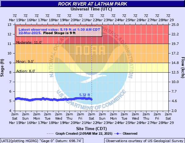
Rock River at Latham Park
Critical Stages
8' - Action
9' - Flood
11' - Moderate
13.5' - Major
Latest Observation
Updated: 4:30 AM CST 12/8/25
Status: No Flooding
Stage: 4.06 ft
Flow: 2.44 kcfs
Forecast
Forecast not available for this location.
| Time | Stage (ft) | Flow (kcfs) |
|---|---|---|
| 4:30 AM 12/8 | 4.06 | 2.44 |
| 4:15 AM 12/8 | 4.06 | 2.44 |
| 4:00 AM 12/8 | 4.08 | 2.48 |
| 3:45 AM 12/8 | 4.1 | 2.51 |
| 3:30 AM 12/8 | 4.11 | 2.53 |
| 3:15 AM 12/8 | 4.12 | 2.55 |
| 3:00 AM 12/8 | 4.14 | 2.58 |
| 2:45 AM 12/8 | 4.15 | 2.6 |
| 2:30 AM 12/8 | 4.16 | 2.62 |
| 2:15 AM 12/8 | 4.18 | 2.66 |
| 2:00 AM 12/8 | 4.2 | 2.69 |
| 1:45 AM 12/8 | 4.22 | 2.73 |
| 1:30 AM 12/8 | 4.24 | 2.77 |
| 1:15 AM 12/8 | 4.26 | 2.81 |
| 1:00 AM 12/8 | 4.28 | 2.85 |
| 12:45 AM 12/8 | 4.29 | 2.87 |
| 12:30 AM 12/8 | 4.3 | 2.89 |
| 12:15 AM 12/8 | 4.31 | 2.91 |
| 12:00 AM 12/8 | 4.33 | 2.96 |
| 11:45 PM 12/7 | 4.34 | 2.98 |
| 11:30 PM 12/7 | 4.35 | 3.01 |
| 11:15 PM 12/7 | 4.35 | 3.01 |
| 11:00 PM 12/7 | 4.36 | 3.03 |
| 10:45 PM 12/7 | 4.38 | 3.08 |
| 10:30 PM 12/7 | 4.38 | 3.08 |
| 10:15 PM 12/7 | 4.39 | 3.11 |
| 10:00 PM 12/7 | 4.41 | 3.16 |
| 9:45 PM 12/7 | 4.42 | 3.18 |
| 9:30 PM 12/7 | 4.42 | 3.18 |
| 9:15 PM 12/7 | 4.42 | 3.18 |
21' -
Bauer Parkway is threatened in Machesney Park. Riverside Boulevard is threatened in Loves Park.
18.5' -
Ralston Road/Latham Road is threatened near the river in Machesney Park. Widespread inundation of structures and roadways reaches up to half mile from the river in Machesney Park.
17' -
Gleasman Road is threatened east of Old River Road north of Machesney Park. Evelyn Avenue and Forest Grove Street are threatened in Loves Park.
16' -
Numerous structures are threatened along Park Ridge Road in Loves Park.
15.5' -
Park Ridge Road is threatened in Loves Park.
14.5' -
Numerous residences are threatened along Queen Oaks Drive in Machesney Park.
13.5' -
Numerous residences are threatened along Ritter Drive, along Ventura Boulevard north of Ralston Road, and along Shore Drive south of Bauer Parkway in Machesney Park. Residences are threatened along Browns Beach Road in north Rockford. Low-lying structures are threatened along Park Ridge Road in Loves Park.
13' -
Ventura Boulevard is threatened north of Ralston Road in Machesney Park.
12.5' -
Residences threatened along Harbor Oaks Drive north of Machesney Park. Numerous residences are threatened near the river and Shore Drive. Low-lying sections of Rockford Country Club are inundated.
12' -
Low-lying sections of Shorewood Park are inundated in Loves Park.
11.5' -
Queen Oaks Drive is threatened in Machesney Park. Lower-level of elevated structures threatened along Harbor Lights Court west of Machesney Park. Ritter Drive is threatened north of Baldwin Drive in Machesney Park.
11' -
Low-lying sections of Harbor Oaks Drive are threatened in north Machesney Park. Low-lying residences are threatened along Queen Oaks Drive in Machesney Park. Browns Beach Road is threatened in north Rockford. Lower parking lot of Sportscore One is inundated in north Rockford.
10.5' -
Low-lying sections of Shore Drive are threatened between Wilson Avenue and Park Road in Machesney Park. Water overflows low-lying river banks along East Drive in Loves Park. Low-lying areas of Martin Memorial Park are inundated.
10' -
Property and trails near the boat ramp at Bauer Parkway are threatened. Illinois DNR considers closure of the Rock River.
9.5' -
Low-lying areas of Sportscore One are inundated in north Rockford.
9' -
Boathouses threatened along the river in Machesney Park.
8' -
Water overflows low-lying river banks along Baldwin Drive and North Pier Drive in Machesney Park. Winnebago County considers "no wake" order for the Rock River.
7.5' -
Low-lying agricultural land is inundated in north Machesney Park.
7' -
Water overflows low-lying river banks along Ventura Boulevard in Machesney Park.
| Date | Stage (ft) |
|---|---|
| Mar 26, 1975 | 14.7 |
| Mar 17, 2019 | 14.46 |
| Jun 18, 2008 | 14.3 |
| Apr 23, 1973 | 13.3 |
| Oct 7, 2018 | 13.22 |
| Jul 29, 2010 | 12.91 |
| Apr 22, 2013 | 12.82 |
| Feb 26, 2018 | 12.8 |
| Jul 28, 2017 | 12.55 |
| Apr 3, 1979 | 12.3 |
| Oct 7, 2019 | 12.23 |
| Apr 5, 1959 | 12.1 |
| Jan 14, 2016 | 11.83 |
| Jun 27, 2013 | 11.55 |
| Sep 9, 2018 | 11.48 |
| Mar 29, 2009 | 10.9 |
| Aug 26, 2007 | 10.74 |
| Jun 4, 2004 | 10.61 |
| Jul 17, 2024 | 10.27 |
| Feb 5, 2019 | 10.22 |
Data provided by the National Weather Service.