« Back to Jefferson County Rivers
Crawfish River at Milford
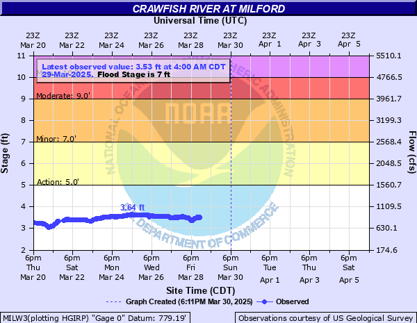
Critical Stages
5' - Action
7' - Flood
9' - Moderate
10' - Major
Latest Observation
Updated: 4:00 AM CST 12/8/25
Status: No Flooding
Stage: 2.56 ft
Flow: 0.339 kcfs
Forecast
Forecast not available for this location.
| Time | Stage (ft) | Flow (kcfs) |
|---|---|---|
| 4:00 AM 12/8 | 2.56 | 0.339 |
| 3:45 AM 12/8 | 2.55 | 0.335 |
| 3:30 AM 12/8 | 2.55 | 0.335 |
| 3:15 AM 12/8 | 2.54 | 0.331 |
| 3:00 AM 12/8 | 2.53 | 0.326 |
| 2:45 AM 12/8 | 2.53 | 0.326 |
| 2:30 AM 12/8 | 2.52 | 0.322 |
| 2:15 AM 12/8 | 2.51 | 0.318 |
| 2:00 AM 12/8 | 2.51 | 0.318 |
| 1:45 AM 12/8 | 2.5 | 0.314 |
| 1:30 AM 12/8 | 2.5 | 0.314 |
| 1:15 AM 12/8 | 2.49 | 0.31 |
| 1:00 AM 12/8 | 2.48 | 0.305 |
| 12:45 AM 12/8 | 2.48 | 0.305 |
| 12:30 AM 12/8 | 2.47 | 0.301 |
| 12:15 AM 12/8 | 2.46 | 0.297 |
| 12:00 AM 12/8 | 2.46 | 0.297 |
| 11:45 PM 12/7 | 2.45 | 0.293 |
| 11:30 PM 12/7 | 2.45 | 0.293 |
| 11:15 PM 12/7 | 2.44 | 0.289 |
| 11:00 PM 12/7 | 2.43 | 0.285 |
| 10:45 PM 12/7 | 2.43 | 0.285 |
| 10:30 PM 12/7 | 2.42 | 0.281 |
| 10:15 PM 12/7 | 2.41 | 0.277 |
| 10:00 PM 12/7 | 2.41 | 0.277 |
| 9:45 PM 12/7 | 2.4 | 0.273 |
| 9:30 PM 12/7 | 2.39 | 0.269 |
| 9:15 PM 12/7 | 2.39 | 0.269 |
| 9:00 PM 12/7 | 2.38 | 0.265 |
| 8:45 PM 12/7 | 2.38 | 0.265 |
13' -
Some homes in Milford are affected by floodwaters. There is widespread agricultural land flooding as well as flooding in Riverbend Campground, about 5 miles upstream of Milford.
12' -
Water is near homes in Milford. There is widespread flooding in Riverbend Campground, about 5 miles upstream of Milford. There is widespread flooding of agricultural land.
11' -
Floodwaters are near some homes in Milford. There is widespread flooding in Riverbend Campground, about 5 miles upstream of Milford.
10' -
Water approaches some homes in Milford. There is widespread flooding of roads in Riverbend Campground, about 5 miles upstream of Milford.
9' -
Water approaches some homes in Milford. There is widespread flooding of roads in Riverbend Campground, about 5 miles upstream of Milford.
8' -
There is widespread flooding of agricultural land and lowland. There is widespread flooding in Riverbend Campground, about 5 miles upstream of Milford.
7' -
There is widespread flooding of lowland and agricultural land. There is widespread flooding of roads in Riverbend Campground about 5 miles upstream of Milford.
6' -
There is minor flooding in the Milford area. Water covers some roads adjacent to the river in Riverbend Campground, about 5 miles upstream of Milford.
5' -
There is minor lowland flooding in the Milford area. About 5 miles upstream, minor flooding starts in Riverbend Campground.
| Date | Stage (ft) |
|---|---|
| Jun 16, 2008 | 13.35 |
| Apr 6, 1959 | 11.15 |
| Apr 2, 1979 | 10.06 |
| Mar 26, 1975 | 9.79 |
| Mar 20, 2019 | 9.4 |
| Apr 23, 1993 | 9.36 |
| Mar 24, 1986 | 9.1 |
| Apr 1, 1962 | 8.88 |
| Mar 17, 1946 | 8.88 |
| Oct 4, 1986 | 8.78 |
| Mar 25, 1952 | 8.76 |
| Apr 20, 2013 | 8.71 |
| Sep 8, 2018 | 8.67 |
| Jun 2, 2004 | 8.63 |
| Apr 3, 1960 | 8.45 |
| Oct 9, 2019 | 8.38 |
| Jun 7, 2000 | 8.38 |
| Mar 22, 1948 | 8.3 |
| Jul 28, 2010 | 8.28 |
| Jun 22, 1996 | 8.27 |
Data provided by the National Weather Service.