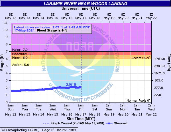
Laramie River near Woods Landing
Critical Stages
5' - Action
6' - Flood
6.5' - Moderate
7' - Major
Latest Observation
Updated: 5:45 PM MST 12/15/25
Status: No Flooding
Stage: 1.27 ft
Flow: 0.0445 kcfs
Forecast
Forecast not available for this location.
| Time | Stage (ft) | Flow (kcfs) |
|---|---|---|
| 5:45 PM 12/15 | 1.27 | 0.0445 |
| 5:30 PM 12/15 | 1.27 | 0.0445 |
| 5:15 PM 12/15 | 1.27 | 0.0445 |
| 5:00 PM 12/15 | 1.27 | 0.0445 |
| 4:45 PM 12/15 | 1.27 | 0.0445 |
| 4:30 PM 12/15 | 1.27 | 0.0445 |
| 4:15 PM 12/15 | 1.27 | 0.0445 |
| 4:00 PM 12/15 | 1.27 | 0.0445 |
| 3:45 PM 12/15 | 1.27 | 0.0445 |
| 3:30 PM 12/15 | 1.27 | 0.0445 |
| 3:15 PM 12/15 | 1.27 | 0.0445 |
| 3:00 PM 12/15 | 1.26 | 0.0428 |
| 2:45 PM 12/15 | 1.26 | 0.0428 |
| 2:30 PM 12/15 | 1.26 | 0.0428 |
| 2:15 PM 12/15 | 1.25 | 0.0412 |
| 2:00 PM 12/15 | 1.25 | 0.0412 |
| 1:45 PM 12/15 | 1.25 | 0.0412 |
| 1:30 PM 12/15 | 1.24 | 0.0396 |
| 1:15 PM 12/15 | 1.24 | 0.0396 |
| 1:00 PM 12/15 | 1.24 | 0.0396 |
| 12:45 PM 12/15 | 1.24 | 0.0396 |
| 12:30 PM 12/15 | 1.25 | 0.0412 |
| 12:15 PM 12/15 | 1.27 | 0.0445 |
| 12:00 PM 12/15 | 1.28 | 0.0463 |
| 11:45 AM 12/15 | 1.29 | 0.0481 |
| 11:30 AM 12/15 | 1.28 | 0.0463 |
| 11:15 AM 12/15 | 1.26 | 0.0428 |
| 11:00 AM 12/15 | 1.23 | 0.038 |
| 10:45 AM 12/15 | 1.21 | 0.0346 |
| 10:30 AM 12/15 | 1.2 | 0.033 |
7' -
MAJOR FLOOD. IMPACTS UNKNOWN.
6.5' -
MODERATE FLOOD. IMPACTS UNKNOWN.
6' -
Flood stage. LOW LYING AGRICULTURAL LAND NEAR THE RIVER IS INUNDATED. RANCH BUILDINGS ALONG RIVER ABOVE GAGE NEAR WOODS LANDING AND JELM ARE AFFECTED.
5.95' -
Record stage and flow of 5,060 cfs established on June 10 1923.
5' -
Bankfull stage. Flooding of ranchlands and low lying agricultural areas begins.
| Date | Stage (ft) |
|---|---|
| Jun 10, 1923 | 5.95 |
| Jun 20, 1983 | 5.32 |
| May 31, 2014 | 5.11 |
| Jun 10, 1986 | 5.1 |
| Jun 18, 2011 | 4.91 |
| May 25, 1984 | 4.81 |
| Jun 9, 2010 | 4.77 |
| Jun 18, 1995 | 4.68 |
| May 15, 1973 | 4.63 |
| May 30, 1979 | 4.42 |
| Jun 3, 1997 | 4.42 |
| Jun 6, 2005 | 4.35 |
| Jun 2, 2003 | 4.23 |
| May 23, 2016 | 4.13 |
| May 19, 1996 | 4.12 |
| Jun 12, 2015 | 4.09 |
| Jun 13, 2022 | 4 |
| May 25, 1980 | 3.91 |
| May 25, 1999 | 3.89 |
| Jun 5, 2008 | 3.88 |
Data provided by the National Weather Service.