« Back to Jenkinson Lake Rivers
West Fork Carson River at Woodfords
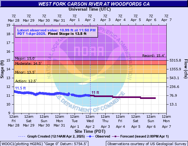
Critical Stages
12.5' - Action
13.5' - Flood
14.5' - Moderate
15' - Major
Latest Observation
Updated: 7:35 AM PST 12/6/25
Status: No Flooding
Stage: 9.94 ft
Flow: 0.026 kcfs
Forecast
| Time | Stage (ft) | Flow (kcfs) |
|---|---|---|
| 8 AM 12/6 | 9.88 | 0.023 |
| 9 AM 12/6 | 9.88 | 0.023 |
| 10 AM 12/6 | 9.87 | 0.022 |
| 11 AM 12/6 | 9.87 | 0.022 |
| 12 PM 12/6 | 9.87 | 0.022 |
| 1 PM 12/6 | 9.87 | 0.022 |
| 2 PM 12/6 | 9.87 | 0.022 |
| 3 PM 12/6 | 9.87 | 0.022 |
| 4 PM 12/6 | 9.87 | 0.022 |
| 5 PM 12/6 | 9.87 | 0.022 |
| 6 PM 12/6 | 9.87 | 0.022 |
| 7 PM 12/6 | 9.87 | 0.022 |
| 8 PM 12/6 | 9.88 | 0.023 |
| 9 PM 12/6 | 9.88 | 0.023 |
| 10 PM 12/6 | 9.88 | 0.023 |
| 11 PM 12/6 | 9.88 | 0.023 |
| 12 AM 12/7 | 9.88 | 0.023 |
| 1 AM 12/7 | 9.87 | 0.022 |
| 2 AM 12/7 | 9.87 | 0.022 |
| 3 AM 12/7 | 9.87 | 0.022 |
| 4 AM 12/7 | 9.87 | 0.022 |
| 5 AM 12/7 | 9.86 | 0.022 |
| 6 AM 12/7 | 9.86 | 0.022 |
| 7 AM 12/7 | 9.86 | 0.022 |
| 8 AM 12/7 | 9.86 | 0.022 |
| 9 AM 12/7 | 9.86 | 0.022 |
| 10 AM 12/7 | 9.86 | 0.022 |
| 11 AM 12/7 | 9.85 | 0.022 |
| 12 PM 12/7 | 9.85 | 0.022 |
| 1 PM 12/7 | 9.85 | 0.022 |
| 2 PM 12/7 | 9.85 | 0.022 |
| 3 PM 12/7 | 9.86 | 0.022 |
| 4 PM 12/7 | 9.85 | 0.022 |
| 5 PM 12/7 | 9.85 | 0.022 |
| 6 PM 12/7 | 9.86 | 0.022 |
| 7 PM 12/7 | 9.86 | 0.022 |
| 8 PM 12/7 | 9.86 | 0.022 |
| 9 PM 12/7 | 9.86 | 0.022 |
| 10 PM 12/7 | 9.86 | 0.022 |
| 11 PM 12/7 | 9.86 | 0.022 |
| 12 AM 12/8 | 9.86 | 0.022 |
| 1 AM 12/8 | 9.86 | 0.022 |
| 2 AM 12/8 | 9.86 | 0.022 |
| 3 AM 12/8 | 9.85 | 0.022 |
| 4 AM 12/8 | 9.85 | 0.022 |
| 5 AM 12/8 | 9.85 | 0.022 |
| 6 AM 12/8 | 9.85 | 0.022 |
| 7 AM 12/8 | 9.84 | 0.021 |
| 8 AM 12/8 | 9.84 | 0.021 |
| 9 AM 12/8 | 9.84 | 0.021 |
| 10 AM 12/8 | 9.84 | 0.021 |
| 11 AM 12/8 | 9.84 | 0.021 |
| 12 PM 12/8 | 9.84 | 0.021 |
| 1 PM 12/8 | 9.84 | 0.021 |
| 2 PM 12/8 | 9.84 | 0.021 |
| 3 PM 12/8 | 9.84 | 0.021 |
| 4 PM 12/8 | 9.84 | 0.021 |
| 5 PM 12/8 | 9.84 | 0.021 |
| 6 PM 12/8 | 9.84 | 0.021 |
| 7 PM 12/8 | 9.84 | 0.021 |
| 8 PM 12/8 | 9.84 | 0.021 |
| 9 PM 12/8 | 9.84 | 0.021 |
| 10 PM 12/8 | 9.85 | 0.022 |
| 11 PM 12/8 | 9.85 | 0.022 |
| 12 AM 12/9 | 9.85 | 0.022 |
| 1 AM 12/9 | 9.84 | 0.021 |
| 2 AM 12/9 | 9.84 | 0.021 |
| 3 AM 12/9 | 9.84 | 0.021 |
| 4 AM 12/9 | 9.84 | 0.021 |
| 5 AM 12/9 | 9.84 | 0.021 |
| 6 AM 12/9 | 9.84 | 0.021 |
| 7 AM 12/9 | 9.83 | 0.021 |
| 8 AM 12/9 | 9.83 | 0.021 |
| 9 AM 12/9 | 9.83 | 0.021 |
| 10 AM 12/9 | 9.83 | 0.021 |
| 11 AM 12/9 | 9.83 | 0.021 |
| 12 PM 12/9 | 9.83 | 0.021 |
| 1 PM 12/9 | 9.83 | 0.021 |
| 2 PM 12/9 | 9.83 | 0.021 |
| 3 PM 12/9 | 9.83 | 0.021 |
| 4 PM 12/9 | 9.83 | 0.021 |
| 5 PM 12/9 | 9.83 | 0.021 |
| 6 PM 12/9 | 9.83 | 0.021 |
| 7 PM 12/9 | 9.83 | 0.021 |
| 8 PM 12/9 | 9.84 | 0.021 |
| 9 PM 12/9 | 9.84 | 0.021 |
| 10 PM 12/9 | 9.84 | 0.021 |
| 11 PM 12/9 | 9.84 | 0.021 |
| 12 AM 12/10 | 9.84 | 0.021 |
| 1 AM 12/10 | 9.83 | 0.021 |
| 2 AM 12/10 | 9.83 | 0.021 |
| 3 AM 12/10 | 9.83 | 0.021 |
| 4 AM 12/10 | 9.83 | 0.021 |
| Time | Stage (ft) | Flow (kcfs) |
|---|---|---|
| 7:35 AM 12/6 | 9.94 | 0.026 |
| 7:30 AM 12/6 | 9.94 | 0.026 |
| 7:25 AM 12/6 | 9.94 | 0.026 |
| 7:20 AM 12/6 | 9.94 | 0.026 |
| 7:15 AM 12/6 | 9.94 | 0.026 |
| 7:10 AM 12/6 | 9.94 | 0.026 |
| 7:05 AM 12/6 | 9.94 | 0.026 |
| 7:00 AM 12/6 | 9.94 | 0.026 |
| 6:55 AM 12/6 | 9.94 | 0.026 |
| 6:50 AM 12/6 | 9.95 | 0.026 |
| 6:45 AM 12/6 | 9.95 | 0.026 |
| 6:40 AM 12/6 | 9.95 | 0.026 |
| 6:35 AM 12/6 | 9.94 | 0.026 |
| 6:30 AM 12/6 | 9.95 | 0.026 |
| 6:25 AM 12/6 | 9.95 | 0.026 |
| 6:20 AM 12/6 | 9.95 | 0.026 |
| 6:15 AM 12/6 | 9.95 | 0.026 |
| 6:10 AM 12/6 | 9.95 | 0.026 |
| 6:05 AM 12/6 | 9.95 | 0.026 |
| 6:00 AM 12/6 | 9.95 | 0.026 |
| 5:55 AM 12/6 | 9.95 | 0.026 |
| 5:50 AM 12/6 | 9.95 | 0.026 |
| 5:45 AM 12/6 | 9.95 | 0.026 |
| 5:40 AM 12/6 | 9.95 | 0.026 |
| 5:35 AM 12/6 | 9.95 | 0.026 |
| 5:30 AM 12/6 | 9.95 | 0.026 |
| 5:25 AM 12/6 | 9.95 | 0.026 |
| 5:20 AM 12/6 | 9.95 | 0.026 |
| 5:15 AM 12/6 | 9.95 | 0.026 |
| 5:10 AM 12/6 | 9.95 | 0.026 |
15.5' -
Disastrous, record flooding along entire reach of West Fork Carson River in both Alpine County, California, and Douglas County, Nevada. Extensive damage to homes, businesses, schools, roads, bridges, and irrigation systems. Communications, power, and transportation systems severely disrupted. Many highways, roads, and bridges impassable. Roughly Similar peak level to January 1997 event.
15' -
Major Flooding. Substantial damage to homes, businesses, schools, and property in south Carson Valley from Centerville to Genoa. Many local roads flood including Centerville, Mottsville, and Muller Lanes. Interruption of power, communications, and water systems. Major flooding also in Alpine County, California, near Woodfords and Paynesville. CA Highways 89 and 88, and NV Highway 88 flood. Downstream Hwy 395 floods.
14.5' -
Moderate flooding in southwest Carson Valley between Centerville and Genoa, with some damage to homes and businesses. Many local roads flooded in this area. Minor to moderate flooding in Alpine County, California, near Woodfords and Paynesville. Lane or road closures on Highway 395 north of Stephanie Way likely if combined with flood flows on the East Fork. Similar peak level to December 2005 event.
14' -
Minor flooding in the southwestern Carson Valley between Centerville and Genoa,impacting agricultural areas, local roads, and outbuildings. Impacts will be more significant if heavy rain and/or snowmelt cause significant rises in small creeks draining the east side of the Carson Range below Woodfords. Possible lane closures on Highway 395 north of Stephanie Way if combined with flood flows on the East Fork. Similar peak level to January 2017 event and May 2017 peak snowmelt.
13.5' -
Minor flooding begins in lowest areas along the West Fork of the Carson River in southwest Carson Valley including agricultural areas, local roads and outbuildings. Residents along the river should prepare for more serious flooding if there are additional rises expected due to snowmelt and/or rainfall runoff. Impacts will be more significant if heavy rain and/or snowmelt causes significant rises in small creeks draining the east side of the Carson Range below Woodfords. Similar to peak of Feb 2017 event.
12.5' -
Monitoring Stage. No flooding occurs. However, residents along the West Fork Carson River should be prepared for flooding if there are additional rises expected due to snowmelt and/or rainfall runoff.
| Date | Stage (ft) |
|---|---|
| Jan 1, 1997 | 15.36 |
| Feb 1, 1963 | 14.95 |
| Dec 23, 1955 | 14.92 |
| Nov 20, 1950 | 14.91 |
| Dec 11, 1937 | 14.65 |
| Dec 23, 1964 | 14.53 |
| May 16, 1996 | 14.51 |
| Apr 7, 2018 | 14.42 |
| Dec 31, 2005 | 14.41 |
| May 5, 2017 | 14.29 |
| Jan 9, 2017 | 14.22 |
| May 18, 2005 | 14.2 |
| May 19, 2023 | 14.11 |
| Dec 20, 1981 | 14 |
| May 18, 1958 | 13.96 |
| Mar 8, 1986 | 13.94 |
| May 24, 1967 | 13.92 |
| May 9, 1906 | 13.91 |
| Jun 1, 1995 | 13.84 |
| May 17, 1907 | 13.83 |
Data provided by the National Weather Service.