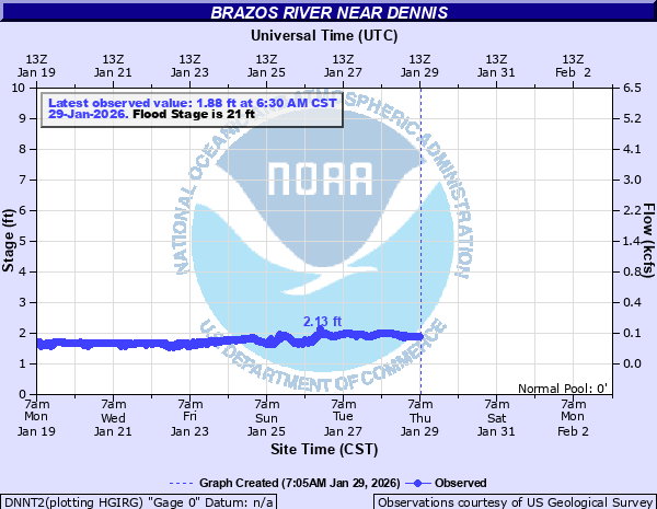
Brazos River near Dennis
Critical Stages
10' - Action
21' - Flood
25' - Moderate
27' - Major
Latest Observation
Updated: 3:45 AM CST 12/6/25
Status: No Flooding
Stage: 1.92 ft
Flow: 0.107 kcfs
Forecast
Forecast not available for this location.
| Time | Stage (ft) | Flow (kcfs) |
|---|---|---|
| 3:45 AM 12/6 | 1.92 | 0.107 |
| 3:30 AM 12/6 | 1.93 | 0.109 |
| 3:15 AM 12/6 | 1.92 | 0.107 |
| 3:00 AM 12/6 | 1.92 | 0.107 |
| 2:45 AM 12/6 | 1.92 | 0.107 |
| 2:30 AM 12/6 | 1.92 | 0.107 |
| 2:15 AM 12/6 | 1.92 | 0.107 |
| 2:00 AM 12/6 | 1.92 | 0.107 |
| 1:45 AM 12/6 | 1.92 | 0.107 |
| 1:30 AM 12/6 | 1.92 | 0.107 |
| 1:15 AM 12/6 | 1.92 | 0.107 |
| 1:00 AM 12/6 | 1.92 | 0.107 |
| 12:45 AM 12/6 | 1.92 | 0.107 |
| 12:30 AM 12/6 | 1.92 | 0.107 |
| 12:15 AM 12/6 | 1.92 | 0.107 |
| 12:00 AM 12/6 | 1.93 | 0.109 |
| 11:45 PM 12/5 | 1.93 | 0.109 |
| 11:30 PM 12/5 | 1.93 | 0.109 |
| 11:15 PM 12/5 | 1.93 | 0.109 |
| 11:00 PM 12/5 | 1.93 | 0.109 |
| 10:45 PM 12/5 | 1.93 | 0.109 |
| 10:30 PM 12/5 | 1.93 | 0.109 |
| 10:15 PM 12/5 | 1.93 | 0.109 |
| 10:00 PM 12/5 | 1.93 | 0.109 |
| 9:45 PM 12/5 | 1.93 | 0.109 |
| 9:30 PM 12/5 | 1.93 | 0.109 |
| 9:15 PM 12/5 | 1.94 | 0.111 |
| 9:00 PM 12/5 | 1.94 | 0.111 |
| 8:45 PM 12/5 | 1.94 | 0.111 |
| 8:30 PM 12/5 | 1.94 | 0.111 |
31.9' -
Extreme flooding is expected downstream to Lake Granbury.
31.5' -
Near record flooding is expected downstream to Lake Granbury. Much of Horsehoe Bend near the river will be flooded with several feet of water. Water will likely reach the portion of Guadalupe Street closest to the river. Homes and structures along Horsehoe Trail, Chippewa Trail, Cherokee Trail, and Chavez Trail will be flooded with several feet of water.
30' -
Major flooding can be expected from Dennis downstream to Horseshoe Bend and to the upper end of Lake Granbury. Water will be several feet deep on the roads near the river and many homes will be flooded on Chavez, Horseshoe Bend, Cherokee and Chippewa Trails.
27' -
Major Flood Stage. Many homes will be cutoff. Several homes will be flooded near the river. Water will be at least 5 feet deep at the intersection of Lipan and Cherokee Trails. Water will approach the intersection of Chavez Trail and Guadalupe. Houses along Horseshoe Bend Trail and Cherokee Taril will be flooded.
26' -
Moderate flooding can be expected downstream at Horseshoe Bend. Chavez Trail and Horseshoe Bend Trail, closest to the river, will be covered in several feet of water.
25' -
Moderate Flood Stage. Several roads near the river at Horseshoe Bend will be covered in water and become impassible.
21' -
Minor Flood Stage. Water starts to impact Chavez Trail near Cimmaron Trail at Horseshoe Bend.
| Date | Stage (ft) |
|---|---|
| Oct 14, 1981 | 31.88 |
| May 1, 1957 | 31.8 |
| Apr 27, 1990 | 31.46 |
| Dec 21, 1991 | 28.06 |
| Feb 21, 1997 | 27.86 |
| Jun 29, 2007 | 27.55 |
| Apr 19, 2016 | 26.91 |
| Jul 2, 2007 | 26.59 |
| Jun 2, 2016 | 26.53 |
| Oct 10, 1986 | 25.86 |
| Aug 10, 1978 | 25.86 |
| May 30, 2015 | 24.52 |
| Nov 29, 2015 | 24.3 |
| Apr 21, 2016 | 24.1 |
| Oct 31, 1974 | 24 |
| Jun 9, 2021 | 23.99 |
| May 28, 2015 | 23.62 |
| Mar 19, 2020 | 23.05 |
| Mar 9, 2016 | 22.7 |
| May 17, 1989 | 22.4 |
Data provided by the National Weather Service.