Tar River at Tarboro
Critical Stages
17' - Action
19' - Flood
24' - Moderate
32' - Major
Latest Observation
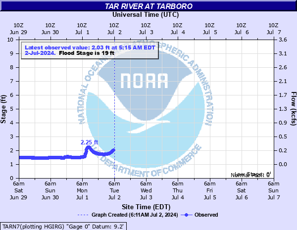
Updated: 3:15 PM EST 12/15/25
Status: No Flooding
Stage: 2.02 ft
Flow: 0.222 kcfs
Forecast
Forecast not available for this location.
| Time | Stage (ft) | Flow (kcfs) |
|---|---|---|
| 3:15 PM 12/15 | 2.02 | 0.222 |
| 3:00 PM 12/15 | 2.03 | 0.225 |
| 2:45 PM 12/15 | 2.02 | 0.222 |
| 2:30 PM 12/15 | 2.02 | 0.222 |
| 2:15 PM 12/15 | 2.02 | 0.222 |
| 2:00 PM 12/15 | 2.02 | 0.222 |
| 1:45 PM 12/15 | 2.02 | 0.222 |
| 1:30 PM 12/15 | 2.02 | 0.222 |
| 1:15 PM 12/15 | 2.02 | 0.222 |
| 1:00 PM 12/15 | 2.02 | 0.222 |
| 12:45 PM 12/15 | 2.02 | 0.222 |
| 12:30 PM 12/15 | 2.02 | 0.222 |
| 12:15 PM 12/15 | -9999 | -999 |
| 12:00 PM 12/15 | 2.02 | 0.222 |
| 11:45 AM 12/15 | 2.02 | 0.222 |
| 11:30 AM 12/15 | 2.03 | 0.225 |
| 11:15 AM 12/15 | 2.03 | 0.225 |
| 11:00 AM 12/15 | 2.03 | 0.225 |
| 10:45 AM 12/15 | 2.03 | 0.225 |
| 10:30 AM 12/15 | 2.03 | 0.225 |
| 10:15 AM 12/15 | -9999 | -999 |
| 10:00 AM 12/15 | 2.02 | 0.222 |
| 9:45 AM 12/15 | 2.03 | 0.225 |
| 9:30 AM 12/15 | 2.03 | 0.225 |
| 9:15 AM 12/15 | 2.03 | 0.225 |
| 9:00 AM 12/15 | 2.03 | 0.225 |
| 8:45 AM 12/15 | 2.03 | 0.225 |
| 8:30 AM 12/15 | 2.03 | 0.225 |
| 8:15 AM 12/15 | 2.03 | 0.225 |
| 8:00 AM 12/15 | 2.03 | 0.225 |
38.6' -
This is the highest elevation of the Princeville levee. Flooding becomes widespread in Princeville. The traffic circle in Tarboro on US64 at the bridge over the Tar river is flooded. Flooding begins on Albemarle Avenue and St Andrews Street.
37' -
Failure may be expected at the Princeville levee and flooding begins in the town of Princeville. There is also considerable street flooding in Tarboro, including Daniels, Baker, St James, and Granville streets.
34.6' -
Water reaches the base of the Princeville levee.
33.6' -
This is the elevation of the railroad bed which cuts through the Princeville levee. The emergency gate must be manually installed to prevent water from flowing into the town of Princeville.
32' -
Major flooding begins. Baker and St James Street begin to flood.
24' -
Moderate flooding begins. River Road in Tarboro is underwater and flooding begins on east Wilson and St David Streets.
20' -
Lowland flooding begins south of Daniel Street in east Tarboro.
19' -
Minor flooding begins. The Riverside Park and River Road at the US64 bridge flood.
17' -
The river is at bankfull.
| Date | Stage (ft) |
|---|---|
| Sep 19, 1999 | 41.51 |
| Oct 13, 2016 | 36.29 |
| Jul 27, 1919 | 34 |
| Oct 4, 1924 | 33.5 |
| Aug 20, 1940 | 31.77 |
| Sep 24, 1928 | 30.2 |
| Sep 1, 1908 | 29.4 |
| May 12, 1958 | 29.17 |
| Apr 22, 1987 | 28.37 |
| Sep 23, 1945 | 28.13 |
| Jun 19, 2006 | 28.03 |
| Oct 7, 1929 | 27.8 |
| May 1, 2017 | 27.7 |
| Feb 21, 2021 | 27.47 |
| Jan 27, 1954 | 27.43 |
| Dec 6, 1934 | 27.38 |
| Apr 23, 1910 | 27.3 |
| Sep 3, 1939 | 27 |
| Sep 15, 1996 | 26.57 |
| Jun 4, 1984 | 26.44 |
Data provided by the National Weather Service.