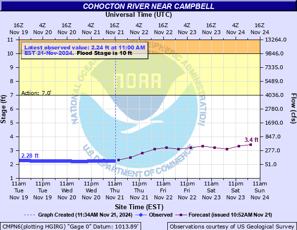
Cohocton River near Campbell
Critical Stages
7' - Action
10' - Flood
12' - Moderate
13' - Major
Latest Observation
Updated: 6:00 AM EST 12/5/25
Status: No Flooding
Stage: 2.35 ft
Flow: 0.0958 kcfs
Forecast
| Time | Stage (ft) | Flow (kcfs) |
|---|---|---|
| 7 AM 12/5 | 2.5 | 0.124 |
| 1 PM 12/5 | 2.5 | 0.124 |
| 7 PM 12/5 | 2.5 | 0.124 |
| 1 AM 12/6 | 2.4 | 0.104 |
| 7 AM 12/6 | 2.4 | 0.104 |
| 1 PM 12/6 | 2.4 | 0.104 |
| 7 PM 12/6 | 2.4 | 0.104 |
| 1 AM 12/7 | 2.4 | 0.104 |
| 7 AM 12/7 | 2.4 | 0.104 |
| Time | Stage (ft) | Flow (kcfs) |
|---|---|---|
| 6:00 AM 12/5 | 2.35 | 0.0958 |
| 5:45 AM 12/5 | 2.34 | 0.0942 |
| 5:30 AM 12/5 | 2.34 | 0.0942 |
| 5:15 AM 12/5 | 2.33 | 0.0926 |
| 5:00 AM 12/5 | 2.35 | 0.0958 |
| 4:45 AM 12/5 | 2.37 | 0.099 |
| 4:30 AM 12/5 | 2.37 | 0.099 |
| 4:15 AM 12/5 | 2.37 | 0.099 |
| 4:00 AM 12/5 | 2.39 | 0.102 |
| 3:45 AM 12/5 | 2.4 | 0.104 |
| 3:30 AM 12/5 | 2.4 | 0.104 |
| 3:15 AM 12/5 | 2.41 | 0.106 |
| 3:00 AM 12/5 | 2.42 | 0.108 |
| 2:45 AM 12/5 | 2.42 | 0.108 |
| 2:30 AM 12/5 | 2.42 | 0.108 |
| 2:15 AM 12/5 | 2.42 | 0.108 |
| 2:00 AM 12/5 | 2.42 | 0.108 |
| 1:45 AM 12/5 | 2.41 | 0.106 |
| 1:30 AM 12/5 | 2.4 | 0.104 |
| 1:15 AM 12/5 | 2.4 | 0.104 |
| 1:00 AM 12/5 | 2.41 | 0.106 |
| 12:45 AM 12/5 | 2.41 | 0.106 |
| 12:30 AM 12/5 | 2.42 | 0.108 |
| 12:15 AM 12/5 | 2.42 | 0.108 |
| 12:00 AM 12/5 | 2.42 | 0.108 |
| 11:45 PM 12/4 | 2.43 | 0.11 |
| 11:30 PM 12/4 | 2.44 | 0.112 |
| 11:15 PM 12/4 | 2.44 | 0.112 |
| 11:00 PM 12/4 | 2.45 | 0.114 |
| 10:45 PM 12/4 | 2.45 | 0.114 |
13.36' -
Flood of record. July 8, 1935.
13.16' -
Flood stage from Hurricane Agnes in June 1972.
13' -
Major flood stage. Water begins to inundate the hamlet of Campbell along Main Street. Dozens of homes threatened of being flooded on their first floor level.
12.33' -
This stage corresponds to the flood of September 26, 1975.
12' -
Moderate flood stage. Savona-Campbell Road closed in several locations due to flood waters. Tannery Road closed due to flood waters. Numerous backyards in Campbell area are flooded.
11' -
Main Street near Campbell-Savona schools covered with about 1 foot of water. Parking lot at school begins to flood. Basement flooding in Hamlet of Campbell becomes widespread at this point.
10' -
Minor flooding starts. Flood waters exit the river channel at Main Street near the Campbell-Savona schools and begin to inundate fields and low spots along the Savona-Campbell Road.
7' -
Savona-Campbell Road begins to flood along the backside of the river.
| Date | Stage (ft) |
|---|---|
| Jul 8, 1935 | 13.6 |
| Jun 23, 1972 | 13.16 |
| Jun 21, 1972 | 12.86 |
| Sep 26, 1975 | 12.33 |
| Jan 19, 1996 | 11.55 |
| Dec 1, 1927 | 11.5 |
| Mar 18, 1963 | 11.35 |
| Mar 12, 1936 | 10.8 |
| Mar 7, 1956 | 10.79 |
| Oct 30, 2021 | 10.78 |
| Mar 12, 1920 | 10.62 |
| Mar 5, 1964 | 10.45 |
| Mar 29, 1950 | 10.38 |
| Mar 21, 1926 | 10.3 |
| Feb 16, 1976 | 10.21 |
| Feb 20, 1939 | 10.15 |
| Apr 1, 1940 | 10.15 |
| Jan 23, 1957 | 10.14 |
| Jun 3, 1947 | 10.1 |
| Mar 17, 1942 | 10.09 |
Data provided by the National Weather Service.