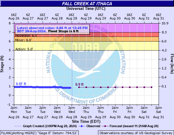
Fall Creek at Ithaca
Critical Stages
5' - Action
6' - Flood
6.5' - Moderate
7' - Major
Latest Observation
Updated: 5:45 AM EST 12/5/25
Status: No Flooding
Stage: 0.81 ft
Flow: 0.0459 kcfs
Forecast
| Time | Stage (ft) | Flow (kcfs) |
|---|---|---|
| 1 PM 12/5 | 1 | 0.068 |
| 7 PM 12/5 | 1 | 0.068 |
| 1 AM 12/6 | 1 | 0.068 |
| 7 AM 12/6 | 1 | 0.068 |
| 1 PM 12/6 | 1 | 0.068 |
| 7 PM 12/6 | 1 | 0.068 |
| 1 AM 12/7 | 1 | 0.068 |
| 7 AM 12/7 | 1 | 0.068 |
| Time | Stage (ft) | Flow (kcfs) |
|---|---|---|
| 5:45 AM 12/5 | 0.81 | 0.0459 |
| 5:30 AM 12/5 | 0.85 | 0.0494 |
| 5:15 AM 12/5 | 0.88 | 0.0522 |
| 5:00 AM 12/5 | 0.89 | 0.0531 |
| 4:45 AM 12/5 | 0.9 | 0.054 |
| 4:30 AM 12/5 | 0.92 | 0.0567 |
| 4:15 AM 12/5 | 0.94 | 0.0594 |
| 4:00 AM 12/5 | 0.94 | 0.0594 |
| 3:45 AM 12/5 | 0.95 | 0.0608 |
| 3:30 AM 12/5 | 0.97 | 0.0636 |
| 3:15 AM 12/5 | 0.98 | 0.0651 |
| 3:00 AM 12/5 | 0.99 | 0.0665 |
| 2:45 AM 12/5 | 1 | 0.068 |
| 2:30 AM 12/5 | 1.01 | 0.0693 |
| 2:15 AM 12/5 | 1.03 | 0.0721 |
| 2:00 AM 12/5 | 1.04 | 0.0734 |
| 1:45 AM 12/5 | 1.06 | 0.0762 |
| 1:30 AM 12/5 | 1.07 | 0.0777 |
| 1:15 AM 12/5 | 1.08 | 0.0791 |
| 1:00 AM 12/5 | 1.09 | 0.0805 |
| 12:45 AM 12/5 | 1.11 | 0.0837 |
| 12:30 AM 12/5 | 1.11 | 0.0837 |
| 12:15 AM 12/5 | 1.1 | 0.082 |
| 12:00 AM 12/5 | 1.11 | 0.0837 |
| 11:45 PM 12/4 | 1.11 | 0.0837 |
| 11:30 PM 12/4 | 1.11 | 0.0837 |
| 11:15 PM 12/4 | 1.11 | 0.0837 |
| 11:00 PM 12/4 | 1.11 | 0.0837 |
| 10:45 PM 12/4 | 1.11 | 0.0837 |
| 10:30 PM 12/4 | 1.11 | 0.0837 |
11.2' -
Ice jam flood crest from February 1971.
9.5' -
Catastrophic flood damage occurred from Etna to downtown Ithaca in July of 1935.
8.4' -
Devastating flood of October 1981. Bridges destroyed. Homes evacuated. Swiftwater rescues occurred from Etna to Forest Home. Several streets in Ithaca's Northside neighborhood were flooded.
8' -
Flooding will damage several bridges upstream of the gage from Varna to Etna.
7.5' -
This is the crest stage from the January 1996 rain on snowmelt with ice jams flooding.
7' -
Widespread flooding of properties and some homes occurs between Varna and Etna. If Cayuga Lake is high, water from Fall Creek completely inundates Stewart Park.
6.5' -
Lower Creek Road is inundated between Varna and Etna. Main Street near Etna is flooded. A few properties between Etna and Varna are affected by flooding. If Cayuga Lake is high, water from Fall Creek will flood roads in Stewart Park.
6.1' -
This is the crest stage of the April 2005 flood.
6' -
Widespread flooding of unoccupied lands occurs nearest the river. Portions of Lower Creek Road will flood.
| Date | Stage (ft) |
|---|---|
| Feb 21, 1971 | 11.16 |
| Jul 8, 1935 | 9.52 |
| Feb 25, 1977 | 9.11 |
| Feb 22, 1955 | 8.84 |
| Jan 21, 1959 | 8.76 |
| Oct 28, 1981 | 8.35 |
| Feb 11, 1966 | 8.25 |
| Mar 2, 1946 | 8.2 |
| Mar 17, 1968 | 8.18 |
| Mar 4, 1934 | 7.8 |
| Feb 8, 1965 | 7.72 |
| Feb 27, 1929 | 7.64 |
| Jan 19, 1996 | 7.47 |
| Mar 15, 1978 | 6.87 |
| Feb 12, 2009 | 6.64 |
| Jan 18, 1990 | 6.62 |
| Mar 2, 1979 | 6.34 |
| Jan 25, 1964 | 6.13 |
| Apr 3, 2005 | 6.1 |
| Jan 24, 1969 | 6.02 |
Data provided by the National Weather Service.