Ohoopee River near Reidsville
Critical Stages
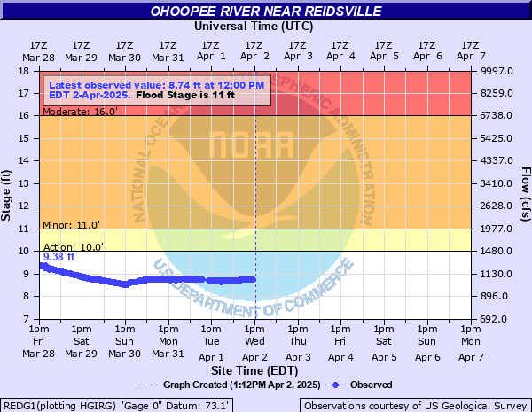
10' - Action
11' - Flood
16' - Moderate
20' - Major
Latest Observation
Updated: 5:00 PM EST 12/15/25
Status: No Flooding
Stage: 3.05 ft
Flow: 0.148 kcfs
Forecast
Forecast not available for this location.
| Time | Stage (ft) | Flow (kcfs) |
|---|---|---|
| 6:00 PM 12/15 | 3.04 | 0.147 |
| 5:45 PM 12/15 | 3.04 | 0.147 |
| 5:30 PM 12/15 | 3.04 | 0.147 |
| 5:15 PM 12/15 | 3.05 | 0.148 |
| 5:00 PM 12/15 | 3.05 | 0.148 |
| 4:45 PM 12/15 | 3.05 | 0.148 |
| 4:30 PM 12/15 | 3.05 | 0.148 |
| 4:15 PM 12/15 | 3.06 | 0.149 |
| 4:00 PM 12/15 | 3.06 | 0.149 |
| 3:45 PM 12/15 | 3.06 | 0.149 |
| 3:30 PM 12/15 | 3.06 | 0.149 |
| 3:15 PM 12/15 | 3.06 | 0.149 |
| 3:00 PM 12/15 | 3.06 | 0.149 |
| 2:45 PM 12/15 | 3.06 | 0.149 |
| 2:30 PM 12/15 | 3.06 | 0.149 |
| 2:15 PM 12/15 | 3.07 | 0.15 |
| 2:00 PM 12/15 | 3.07 | 0.15 |
| 1:45 PM 12/15 | 3.05 | 0.148 |
| 1:30 PM 12/15 | 3.07 | 0.15 |
| 1:15 PM 12/15 | 3.07 | 0.15 |
| 1:00 PM 12/15 | 3.07 | 0.15 |
| 12:45 PM 12/15 | 3.08 | 0.151 |
| 12:30 PM 12/15 | 3.03 | 0.146 |
| 12:15 PM 12/15 | 3.08 | 0.151 |
| 12:00 PM 12/15 | 3.08 | 0.151 |
| 11:45 AM 12/15 | 3.08 | 0.151 |
| 11:30 AM 12/15 | 3.08 | 0.151 |
| 11:15 AM 12/15 | 3.08 | 0.151 |
| 11:00 AM 12/15 | 3.08 | 0.151 |
| 10:45 AM 12/15 | 3.09 | 0.152 |
28.4' -
record flooding will occur.
19' -
the access road into the Joy Bluff community is covered with 1.5 feet of water.
17.5' -
water enters the ground level of homes in the Joy Bluff community. The access road becomes covered with water.
14' -
flooding of several riverside unimproved roads and some agricultural land occurs.
11' -
water enters the back yards of some homes in the Joy Bluff community.
| Date | Stage (ft) |
|---|---|
| Jan 1, 1925 | 28.4 |
| Oct 1, 1929 | 24 |
| Mar 6, 1966 | 23.34 |
| Mar 11, 1998 | 22.5 |
| Jan 14, 1993 | 22.44 |
| Feb 23, 2020 | 21.22 |
| Mar 7, 1991 | 21.08 |
| Nov 9, 2024 | 20.95 |
| Mar 17, 1980 | 20.87 |
| Mar 30, 2005 | 20.72 |
| Aug 1, 1928 | 20.6 |
| Oct 2, 2024 | 20.19 |
| Feb 28, 1979 | 19.83 |
| Mar 3, 1939 | 19.8 |
| Apr 8, 1960 | 19.8 |
| Feb 20, 1965 | 19.71 |
| Aug 16, 1940 | 19.7 |
| Jan 25, 1987 | 19.62 |
| Feb 19, 2021 | 19.51 |
| Apr 4, 1948 | 19.3 |
Data provided by the National Weather Service.