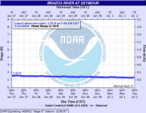
Brazos River at Seymour
Critical Stages
10' - Action
12' - Flood
15' - Moderate
20' - Major
Latest Observation
Updated: 2:45 PM CST 12/15/25
Status: No Flooding
Stage: 0.9 ft
Flow: 0.03 kcfs
Forecast
Forecast not available for this location.
| Time | Stage (ft) | Flow (kcfs) |
|---|---|---|
| 2:45 PM 12/15 | 0.9 | 0.03 |
| 2:30 PM 12/15 | 0.88 | 0.028 |
| 2:15 PM 12/15 | 0.9 | 0.03 |
| 2:00 PM 12/15 | 0.88 | 0.028 |
| 1:45 PM 12/15 | 0.9 | 0.03 |
| 1:30 PM 12/15 | 0.91 | 0.031 |
| 1:15 PM 12/15 | 0.89 | 0.029 |
| 1:00 PM 12/15 | 0.91 | 0.031 |
| 12:45 PM 12/15 | 0.88 | 0.028 |
| 12:30 PM 12/15 | 0.91 | 0.031 |
| 12:15 PM 12/15 | 0.91 | 0.031 |
| 12:00 PM 12/15 | 0.9 | 0.03 |
| 11:45 AM 12/15 | 0.87 | 0.0271 |
| 11:30 AM 12/15 | 0.89 | 0.029 |
| 11:15 AM 12/15 | 0.88 | 0.028 |
| 11:00 AM 12/15 | 0.9 | 0.03 |
| 10:45 AM 12/15 | 0.9 | 0.03 |
| 10:30 AM 12/15 | 0.91 | 0.031 |
| 10:15 AM 12/15 | 0.89 | 0.029 |
| 10:00 AM 12/15 | 0.89 | 0.029 |
| 9:45 AM 12/15 | 0.89 | 0.029 |
| 9:30 AM 12/15 | 0.91 | 0.031 |
| 9:15 AM 12/15 | 0.91 | 0.031 |
| 9:00 AM 12/15 | 0.91 | 0.031 |
| 8:45 AM 12/15 | 0.91 | 0.031 |
| 8:30 AM 12/15 | 0.91 | 0.031 |
| 8:15 AM 12/15 | 0.91 | 0.031 |
| 8:00 AM 12/15 | 0.91 | 0.031 |
| 7:45 AM 12/15 | 0.91 | 0.031 |
| 7:30 AM 12/15 | 0.91 | 0.031 |
22' -
Croplands...pastures...and local highways flood across most of the river valley...in southern Knox and southern Baylor counties. Rural areas may have overflow depths up to 10 feet...along with very devastating currents.
21' -
Croplands...pastures...and local highways flood across most of the river valley...in southern Knox and southern Baylor counties. Rural areas may have overflow depths up to 9 feet...along with very devastating currents.
20' -
Croplands...pastures...and local highways flood across most of the river valley...in southern Knox and southern Baylor counties. Rural areas may have overflow depths up to 8 feet...along with very devastating currents.
19' -
Croplands...pastures...and local highways flood across most of the river valley...in southern Knox and southern Baylor counties. Rural areas may have overflow depths up to 7 feet...along with very devastating currents.
18' -
Croplands...pastures...and local highways flood across most of the river valley...in southern Knox and southern Baylor counties. Rural areas may have overflow depths up to 6 feet...along with very devastating currents.
17' -
Croplands...pastures...and local roads flood along the river in southern Baylor and southern Knox counties. Rural areas may have overflow depths up to 5 feet...along with very dangerous currents.
16' -
Flooding affects croplands...pastures...and rural roads along the river in southern Knox and southern Baylor counties. Low-lying areas may experience depths up to 4 feet...with dangerous currents.
15' -
Flooding affects croplands...pastures...and rural roads along the river in southern Knox and southern Baylor counties. Low-lying areas may experience depths up to 3 feet...with dangerous currents.
14' -
Short duration flooding affects low-lying areas along and near the river in southern Knox and southern Baylor counties.
13' -
Short duration flooding affects low-lying areas along and near the river in southern Knox and southern Baylor counties.
12' -
Shallow and short duration flooding affects low-lying areas along and near the river in southern Knox and southern Baylor counties.
11' -
Near bankfull stages occur along the river in southern Knox and southern Baylor counties.
10' -
The river remains within its banks in southern Knox and southern Baylor counties.
| Date | Stage (ft) |
|---|---|
| Sep 28, 1955 | 23 |
| Oct 5, 1955 | 18.98 |
| Aug 17, 2005 | 18.6 |
| Oct 20, 1960 | 18.54 |
| Aug 16, 1972 | 18.35 |
| Jun 4, 1990 | 17.37 |
| Oct 16, 1926 | 17.16 |
| Aug 29, 1926 | 15.77 |
| Jun 14, 1930 | 15 |
| May 30, 1987 | 14.95 |
| Jul 28, 2004 | 14.94 |
| May 17, 1947 | 14.66 |
| Jun 5, 1991 | 14.62 |
| May 4, 1941 | 14.45 |
| Aug 5, 1978 | 14.2 |
| Jun 2, 1935 | 13.55 |
| May 17, 1980 | 13.53 |
| Sep 7, 1932 | 13.4 |
| Jun 11, 2024 | 13.39 |
| Sep 7, 1962 | 13.16 |
Data provided by the National Weather Service.