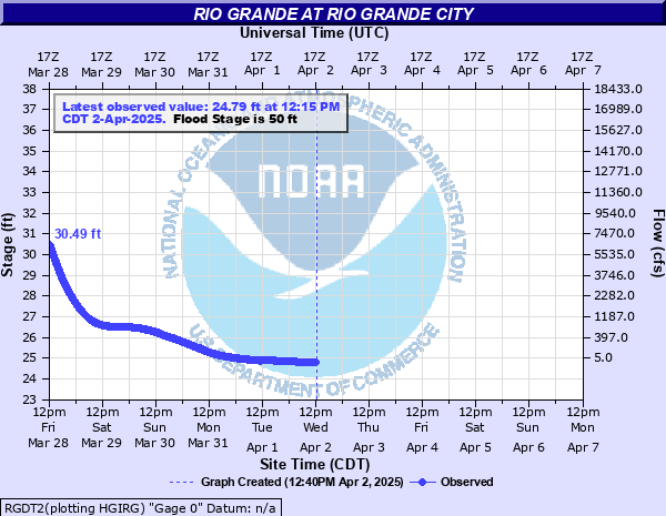
Rio Grande at Rio Grande City
Critical Stages
48' - Action
50' - Flood
51' - Moderate
53' - Major
Latest Observation
Updated: 1:15 AM CST 12/16/25
Status: No Flooding
Stage: 25.18 ft
Flow: 0.487 kcfs
Forecast
Forecast not available for this location.
| Time | Stage (ft) | Flow (kcfs) |
|---|---|---|
| 1:15 AM 12/16 | 25.18 | 0.487 |
| 1:00 AM 12/16 | 25.18 | 0.487 |
| 12:45 AM 12/16 | 25.19 | 0.493 |
| 12:30 AM 12/16 | 25.19 | 0.493 |
| 12:15 AM 12/16 | 25.19 | 0.493 |
| 12:00 AM 12/16 | 25.19 | 0.493 |
| 11:45 PM 12/15 | 25.19 | 0.493 |
| 11:30 PM 12/15 | 25.2 | 0.5 |
| 11:15 PM 12/15 | 25.19 | 0.493 |
| 11:00 PM 12/15 | 25.2 | 0.5 |
| 10:45 PM 12/15 | 25.2 | 0.5 |
| 10:30 PM 12/15 | 25.19 | 0.493 |
| 10:15 PM 12/15 | 25.19 | 0.493 |
| 10:00 PM 12/15 | 25.19 | 0.493 |
| 9:45 PM 12/15 | 25.19 | 0.493 |
| 9:30 PM 12/15 | 25.19 | 0.493 |
| 9:15 PM 12/15 | 25.2 | 0.5 |
| 9:00 PM 12/15 | 25.2 | 0.5 |
| 8:45 PM 12/15 | 25.2 | 0.5 |
| 8:30 PM 12/15 | 25.2 | 0.5 |
| 8:15 PM 12/15 | 25.2 | 0.5 |
| 8:00 PM 12/15 | 25.2 | 0.5 |
| 7:45 PM 12/15 | 25.2 | 0.5 |
| 7:30 PM 12/15 | 25.2 | 0.5 |
| 7:15 PM 12/15 | 25.21 | 0.507 |
| 7:00 PM 12/15 | 25.21 | 0.507 |
| 6:45 PM 12/15 | 25.21 | 0.507 |
| 6:30 PM 12/15 | 25.21 | 0.507 |
| 6:15 PM 12/15 | 25.21 | 0.507 |
| 6:00 PM 12/15 | 25.21 | 0.507 |
66' -
The Rio Grande river reaches lowest areas of Rio Grande City itself - widespread disastrous flooding inundates most of the roads and highways in and out of town - hundreds of homes are flooded
63.5' -
Widespread flooding reaches much of the flood plain south of town and floods Highway 83 west of Rio Grande City - the Rio Grande river backs up the Arroyo Los Olmos and floods Highway 755 and threatens lowest homes in the Los Olmos flood plain
53' -
Major lowland flooding damages irrigation pumps, equipment, roads and threatens livestock - bridges in the flood plain are severely flooded and become dangerous - the river backs up on the Arroyo Los Olmos and floods the lowest homes near Highway 83 and FM 755 as well as floods these roads.
50' -
Irrigation pumps, equipment, livestock, roads and bridges flood in low areas
48' -
Minor lowland flooding damages irrigation pumps and equipment if they are not moved
| Date | Stage (ft) |
|---|---|
| Sep 27, 1972 | 65.78 |
| Jul 11, 2010 | 57.63 |
| Jul 16, 2010 | 57.31 |
| Jul 8, 2010 | 50.06 |
| Jul 27, 2020 | 39.27 |
| Sep 29, 1967 | 32.34 |
| Sep 20, 1971 | 25.29 |
| Sep 21, 1988 | 20.9 |
| Jun 28, 1973 | 19.28 |
| Sep 29, 1978 | 18.99 |
| Aug 26, 1976 | 18.46 |
| Feb 16, 1983 | 9.73 |
| May 16, 1985 | 8.44 |
| Sep 4, 1975 | 6.23 |
| Sep 24, 1974 | 6.2 |
| Jun 16, 1981 | 5.73 |
| Apr 30, 1986 | 5.65 |
| Apr 18, 1994 | 5.58 |
| May 31, 1990 | 5.53 |
| May 27, 1989 | 5.51 |
Data provided by the National Weather Service.