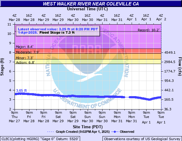
West Walker River near Coleville (Lower Gage)
Critical Stages
6.8' - Action
7.3' - Flood
7.9' - Moderate
8.4' - Major
Latest Observation
Updated: 4:20 PM PST 12/15/25
Status: No Flooding
Stage: 2.46 ft
Flow: 0.072 kcfs
Forecast
Forecast not available for this location.
| Time | Stage (ft) | Flow (kcfs) |
|---|---|---|
| 4:35 PM 12/15 | 2.45 | 0.07 |
| 4:30 PM 12/15 | 2.45 | 0.07 |
| 4:25 PM 12/15 | 2.45 | 0.07 |
| 4:20 PM 12/15 | 2.46 | 0.072 |
| 4:15 PM 12/15 | 2.46 | 0.072 |
| 4:10 PM 12/15 | 2.46 | 0.072 |
| 4:05 PM 12/15 | 2.46 | 0.072 |
| 4:00 PM 12/15 | 2.46 | 0.072 |
| 3:55 PM 12/15 | 2.47 | 0.073 |
| 3:50 PM 12/15 | 2.46 | 0.072 |
| 3:45 PM 12/15 | 2.46 | 0.072 |
| 3:40 PM 12/15 | 2.45 | 0.07 |
| 3:35 PM 12/15 | 2.45 | 0.07 |
| 3:30 PM 12/15 | 2.44 | 0.069 |
| 3:25 PM 12/15 | 2.42 | 0.067 |
| 3:20 PM 12/15 | 2.41 | 0.066 |
| 3:15 PM 12/15 | 2.39 | 0.064 |
| 3:10 PM 12/15 | 2.38 | 0.063 |
| 3:05 PM 12/15 | 2.36 | 0.061 |
| 3:00 PM 12/15 | 2.35 | 0.06 |
| 2:55 PM 12/15 | 2.33 | 0.058 |
| 2:50 PM 12/15 | 2.32 | 0.057 |
| 2:45 PM 12/15 | 2.31 | 0.056 |
| 2:40 PM 12/15 | 2.31 | 0.056 |
| 2:35 PM 12/15 | 2.31 | 0.056 |
| 2:30 PM 12/15 | 2.31 | 0.056 |
| 2:25 PM 12/15 | 2.3 | 0.055 |
| 2:20 PM 12/15 | 2.3 | 0.055 |
| 2:15 PM 12/15 | 2.3 | 0.055 |
| 2:10 PM 12/15 | 2.3 | 0.055 |
8.4' -
Major flooding in the West Walker Canyon and Antelope Valley including Walker, Coleville, and Topaz. Many buildings impacted, and roads flooded or washed out. Major damage to agricultural lands. Extensive sandbagging required to protect property. Transportation affected, with severe damage road damage possible.
7.9' -
Moderate flooding of lowlands, agricultural lands, yards, basements, and rural roads in the West Walker River Canyon and in Antelope Valley including Walker, Colevile, and Topaz California. Flooding of structures limited although some sandbagging necessary. Roughly similar to the June 2017 peak.
7.3' -
Flood Stage, Minor flooding of lowlands, pastrures and rural roads in Antelope Valley. Roughly similar to June 2019 and October 2021 crests.
6.8' -
Monitor Stage, No flooding in Antelope Valley
| Date | Stage (ft) |
|---|---|
| Jan 2, 1997 | 10.23 |
| Dec 11, 1937 | 8.92 |
| Jul 9, 1995 | 7.97 |
| Jun 20, 2017 | 7.95 |
| Jul 3, 1907 | 7.83 |
| Jun 6, 2010 | 7.79 |
| May 16, 1996 | 7.76 |
| May 19, 2006 | 7.76 |
| May 23, 2023 | 7.59 |
| Apr 7, 2018 | 7.58 |
| May 16, 2005 | 7.4 |
| May 29, 2003 | 7.38 |
| Jul 3, 1906 | 7.38 |
| Jun 7, 2019 | 7.35 |
| Jun 1, 1986 | 7.31 |
| Jun 1, 1986 | 7.31 |
| Jun 4, 1969 | 7.26 |
| Oct 25, 2021 | 7.23 |
| Jul 2, 1967 | 7.15 |
| May 29, 1999 | 7.11 |
Data provided by the National Weather Service.