« Back to Lake Linganore Rivers
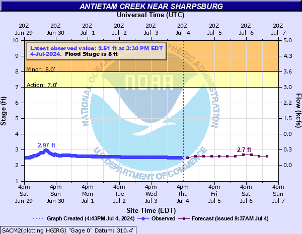
Antietam Creek near Sharpsburg
Critical Stages
7' - Action
8' - Flood
10' - Moderate
12' - Major
Latest Observation
Updated: 1:15 PM EST 12/15/25
Status: No Flooding
Stage: 2.24 ft
Flow: 0.0792 kcfs
Forecast
| Time | Stage (ft) | Flow (kcfs) |
|---|---|---|
| 7 PM 12/15 | 2.3 | 0.093 |
| 1 AM 12/16 | 2.3 | 0.093 |
| 7 AM 12/16 | 2.3 | 0.093 |
| 1 PM 12/16 | 2.3 | 0.093 |
| 7 PM 12/16 | 2.3 | 0.093 |
| 1 AM 12/17 | 2.3 | 0.093 |
| 7 AM 12/17 | 2.3 | 0.093 |
| 1 PM 12/17 | 2.3 | 0.093 |
| 7 PM 12/17 | 2.3 | 0.093 |
| 1 AM 12/18 | 2.3 | 0.093 |
| 7 AM 12/18 | 2.3 | 0.093 |
| Time | Stage (ft) | Flow (kcfs) |
|---|---|---|
| 1:15 PM 12/15 | 2.24 | 0.0792 |
| 1:00 PM 12/15 | 2.24 | 0.0792 |
| 12:45 PM 12/15 | 2.23 | 0.0771 |
| 12:30 PM 12/15 | 2.23 | 0.0771 |
| 12:15 PM 12/15 | 2.23 | 0.0771 |
| 12:00 PM 12/15 | 2.22 | 0.075 |
| 11:45 AM 12/15 | 2.22 | 0.075 |
| 11:30 AM 12/15 | 2.22 | 0.075 |
| 11:15 AM 12/15 | 2.23 | 0.0771 |
| 11:00 AM 12/15 | 2.23 | 0.0771 |
| 10:45 AM 12/15 | 2.23 | 0.0771 |
| 10:30 AM 12/15 | 2.23 | 0.0771 |
| 10:15 AM 12/15 | 2.22 | 0.075 |
| 10:00 AM 12/15 | 2.22 | 0.075 |
| 9:45 AM 12/15 | 2.22 | 0.075 |
| 9:30 AM 12/15 | 2.26 | 0.0836 |
| 9:15 AM 12/15 | 2.3 | 0.093 |
| 9:00 AM 12/15 | 2.34 | 0.102 |
| 8:45 AM 12/15 | 2.35 | 0.104 |
| 8:30 AM 12/15 | 2.35 | 0.104 |
| 8:15 AM 12/15 | 2.36 | 0.106 |
| 8:00 AM 12/15 | 2.36 | 0.106 |
| 7:45 AM 12/15 | 2.36 | 0.106 |
| 7:30 AM 12/15 | 2.36 | 0.106 |
| 7:15 AM 12/15 | 2.36 | 0.106 |
| 7:00 AM 12/15 | 2.34 | 0.102 |
| 6:45 AM 12/15 | 2.33 | 0.0995 |
| 6:30 AM 12/15 | 2.31 | 0.0951 |
| 6:15 AM 12/15 | 2.29 | 0.0906 |
| 6:00 AM 12/15 | 2.28 | 0.0882 |
15' -
Water reaches the top of the arch of the Old Burnside Bridge at Antietam National Battlefield and the treeline near Old Burnside Bridge. Water also approaches the parking lot of the Pry House Medical Museum.
12' -
Water approaches outbuildings off Harpers Ferry Road near Sharpsburg. Significant flooding of low-lying fields near the creek is occurring.
10' -
Land near the creek through Antietam National Battlefield is flooded. The lower portion of a driveway adjoining the creek near Route 34 is flooded. Floodwaters approach at least one home on the left bank near Route 34.
9' -
Water approaches the lowest corner of the Old Burnside Bridge. Burnside Bridge Road and Manor Church Road are flooded and closed, and trails alongside the creek in Antietam Battlefield are flooded.
8' -
A low spot on Burnside Bridge Road, on the south end of Antietam National Battlefield, begins to flood. Flooding on the battlefield along the creek is also occurring, flooding some creekside trails and nearby land. A few small monuments near Burnside Bridge become surrounded by water. Fields off Branch Avenue in Sharpsburg begin to flood.
7' -
Water begins to overflow the banks on both sides in Antietam National Battlefield. Water approaches the low spot on Burnside Bridge Road on the far southern end of the battlefield.
| Date | Stage (ft) |
|---|---|
| Jul 20, 1956 | 16.73 |
| Sep 26, 1975 | 14.71 |
| Jun 23, 1972 | 14.3 |
| Jan 19, 1996 | 13.71 |
| Jul 11, 1928 | 11.9 |
| Oct 9, 1976 | 11.88 |
| Feb 13, 1985 | 11.32 |
| Jul 18, 1949 | 11.23 |
| Jun 28, 2006 | 10.85 |
| Dec 1, 1934 | 10.8 |
| Apr 27, 1937 | 10.67 |
| Aug 24, 1933 | 10.4 |
| Jan 25, 1979 | 10.39 |
| May 25, 1952 | 10.32 |
| Feb 15, 1984 | 10.31 |
| May 16, 2014 | 10.21 |
| Sep 7, 1996 | 9.92 |
| Oct 31, 2012 | 9.89 |
| Jun 19, 1996 | 9.85 |
| May 3, 1929 | 9.8 |
Data provided by the National Weather Service.