« Back to Lake Metigoshe Rivers
Souris River near Westhope
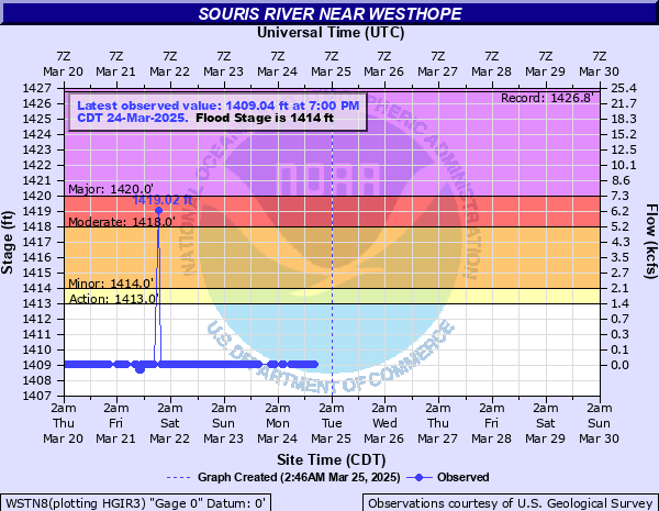
Critical Stages
1413' - Action
1414' - Flood
1418' - Moderate
1420' - Major
Latest Observation
Updated: 12:00 AM CST 12/15/25
Status: No Flooding
Stage: 1409.64 ft
Flow: 0.0272 kcfs
Forecast
Forecast not available for this location.
| Time | Stage (ft) | Flow (kcfs) |
|---|---|---|
| 12:00 AM 12/15 | 1409.64 | 0.0272 |
| 11:45 PM 12/14 | 1409.64 | 0.0272 |
| 11:30 PM 12/14 | 1409.64 | 0.0272 |
| 11:15 PM 12/14 | 1409.64 | 0.0272 |
| 11:00 PM 12/14 | 1409.64 | 0.0272 |
| 10:45 PM 12/14 | 1409.64 | 0.0272 |
| 10:30 PM 12/14 | 1409.65 | 0.0278 |
| 10:15 PM 12/14 | 1409.64 | 0.0272 |
| 10:00 PM 12/14 | 1409.64 | 0.0272 |
| 9:45 PM 12/14 | 1409.64 | 0.0272 |
| 9:30 PM 12/14 | 1409.64 | 0.0272 |
| 9:15 PM 12/14 | 1409.64 | 0.0272 |
| 9:00 PM 12/14 | 1409.65 | 0.0278 |
| 8:45 PM 12/14 | 1409.65 | 0.0278 |
| 8:30 PM 12/14 | 1409.65 | 0.0278 |
| 8:15 PM 12/14 | 1409.65 | 0.0278 |
| 8:00 PM 12/14 | 1409.65 | 0.0278 |
| 7:45 PM 12/14 | 1409.65 | 0.0278 |
| 7:30 PM 12/14 | 1409.65 | 0.0278 |
| 7:15 PM 12/14 | 1409.65 | 0.0278 |
| 7:00 PM 12/14 | 1409.65 | 0.0278 |
| 6:45 PM 12/14 | 1409.65 | 0.0278 |
| 6:30 PM 12/14 | 1409.65 | 0.0278 |
| 6:15 PM 12/14 | 1409.65 | 0.0278 |
| 6:00 PM 12/14 | 1409.65 | 0.0278 |
| 5:45 PM 12/14 | 1409.65 | 0.0278 |
| 5:30 PM 12/14 | 1409.65 | 0.0278 |
| 5:15 PM 12/14 | 1409.65 | 0.0278 |
| 5:00 PM 12/14 | 1409.65 | 0.0278 |
| 4:45 PM 12/14 | 1409.65 | 0.0278 |
1418' -
Refuge area floods. The city of Westhope is on high ground and does not flood. Road to gage is impassable. Access to Dam #357 is OK below 16 feet.
1416' -
Wildlife and refuge flooding only.
1414' -
Water is almost valley-wide. The area flooded is grass covered and no buildings are affected.
| Date | Stage (ft) |
|---|---|
| Jul 5, 2011 | 1426.75 |
| Apr 19, 1969 | 1421.36 |
| Apr 14, 1999 | 1421 |
| Apr 7, 2017 | 1420.86 |
| Jul 6, 2014 | 1420.74 |
| Apr 20, 1949 | 1420.7 |
| May 21, 1979 | 1420.07 |
| Apr 30, 2009 | 1419.98 |
| Apr 9, 1995 | 1419.79 |
| Apr 21, 1996 | 1419.61 |
| Jun 20, 2013 | 1419.52 |
| Apr 25, 1997 | 1417.95 |
| Jul 20, 2005 | 1417.75 |
| Apr 14, 1955 | 1417.62 |
| Apr 15, 2001 | 1417.44 |
| May 1, 1948 | 1417.43 |
| May 23, 1950 | 1416.11 |
| May 21, 1956 | 1415.981 |
| Apr 24, 1982 | 1415.701 |
| Apr 21, 1947 | 1415.17 |
Data provided by the National Weather Service.