« Back to Lake Michigan Beach Rivers
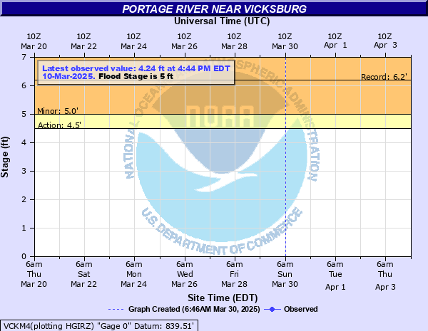
Portage River near Vicksburg
Critical Stages
4.5' - Action
5' - Flood
7' - Moderate
8' - Major
Latest Observation
Updated: 7:03 PM LMT 12/31/00
Status: Obs Not Current
Stage: -999 ft
Flow: -999 kcfs
Forecast
Forecast not available for this location.
| Time | Stage (ft) | Flow (kcfs) |
|---|---|---|
| 4:30 PM 11/14 | 3.83 | 0.0658 |
| 6:03 PM 10/27 | 3.93 | 0.072 |
| 6:00 PM 10/18 | 3.45 | 0.046 |
| 6:19 PM 10/15 | 3.42 | 0.0448 |
8' -
Expect major flooding of several homes built adjacent to the river.
7' -
Expect moderate flooding of several homes built adjacent to the river. Water covers south 29th Street just south of EW Avenue.
6' -
Expect minor basement flooding of several homes built adjacent to the river.
5.5' -
Minor basement flooding begins at the first house near the gage.
5' -
Expect overflows into wooded areas, yards, a few outbuildings, and farmland adjacent to the river.
4.5' -
River is near bankfull.
| Date | Stage (ft) |
|---|---|
| Feb 22, 2018 | 6.18 |
| May 19, 2020 | 5.83 |
| Jun 2, 1989 | 5.81 |
| Aug 18, 2016 | 5.78 |
| Jun 21, 2019 | 5.66 |
| Apr 7, 1947 | 5.66 |
| Mar 23, 1948 | 5.65 |
| Sep 15, 2008 | 5.62 |
| Apr 4, 1950 | 5.55 |
| Feb 27, 1985 | 5.55 |
| May 19, 2018 | 5.49 |
| Mar 7, 2018 | 5.49 |
| Mar 21, 1982 | 5.48 |
| Feb 3, 1968 | 5.47 |
| Mar 12, 2009 | 5.46 |
| Jan 13, 2020 | 5.46 |
| Jul 17, 2024 | 5.45 |
| Mar 5, 1976 | 5.38 |
| Mar 31, 2017 | 5.36 |
| Jun 30, 1978 | 5.35 |
Data provided by the National Weather Service.