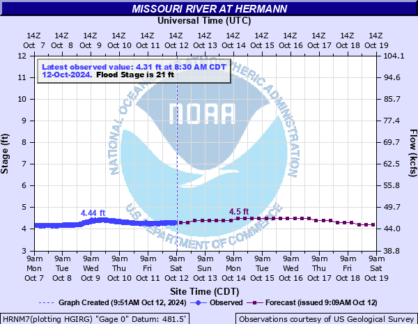
Missouri River at Hermann
Critical Stages
19' - Action
21' - Flood
26' - Moderate
33' - Major
Latest Observation
Updated: 11:30 PM CST 12/14/25
Status: No Flooding
Stage: 1.05 ft
Flow: 29.7 kcfs
Forecast
| Time | Stage (ft) | Flow (kcfs) |
|---|---|---|
| 6 AM 12/15 | 1.2 | 30.4 |
| 12 PM 12/15 | 1.2 | 30.4 |
| 6 PM 12/15 | 1.2 | 30.4 |
| 12 AM 12/16 | 1.3 | 30.8 |
| 6 AM 12/16 | 1.3 | 30.8 |
| 12 PM 12/16 | 1.4 | 31.2 |
| 6 PM 12/16 | 1.5 | 31.7 |
| 12 AM 12/17 | 1.6 | 32.1 |
| 6 AM 12/17 | 1.7 | 32.5 |
| 12 PM 12/17 | 1.7 | 32.5 |
| 6 PM 12/17 | 1.7 | 32.5 |
| 12 AM 12/18 | 1.7 | 32.5 |
| 6 AM 12/18 | 1.7 | 32.5 |
| 12 PM 12/18 | 1.7 | 32.5 |
| 6 PM 12/18 | 1.6 | 32.1 |
| 12 AM 12/19 | 1.6 | 32.1 |
| 6 AM 12/19 | 1.5 | 31.7 |
| 12 PM 12/19 | 1.5 | 31.7 |
| 6 PM 12/19 | 1.4 | 31.2 |
| 12 AM 12/20 | 1.4 | 31.2 |
| 6 AM 12/20 | 1.3 | 30.8 |
| 12 PM 12/20 | 1.2 | 30.4 |
| 6 PM 12/20 | 1.1 | 29.9 |
| 12 AM 12/21 | 1.1 | 29.9 |
| 6 AM 12/21 | 1 | 29.5 |
| Time | Stage (ft) | Flow (kcfs) |
|---|---|---|
| 11:30 PM 12/14 | 1.05 | 29.7 |
| 11:15 PM 12/14 | 1.04 | 29.7 |
| 11:00 PM 12/14 | 1 | 29.5 |
| 10:45 PM 12/14 | 0.98 | 29.4 |
| 10:30 PM 12/14 | 1.02 | 29.6 |
| 10:15 PM 12/14 | 1.04 | 29.7 |
| 10:00 PM 12/14 | 1.04 | 29.7 |
| 9:45 PM 12/14 | 1.05 | 29.7 |
| 9:30 PM 12/14 | 1.04 | 29.7 |
| 9:15 PM 12/14 | 1.04 | 29.7 |
| 9:00 PM 12/14 | 1.04 | 29.7 |
| 8:45 PM 12/14 | 1.04 | 29.7 |
| 8:30 PM 12/14 | 1.05 | 29.7 |
| 8:15 PM 12/14 | 1.04 | 29.7 |
| 8:00 PM 12/14 | 1.04 | 29.7 |
| 7:45 PM 12/14 | 1.04 | 29.7 |
| 7:30 PM 12/14 | 1.03 | 29.6 |
| 7:15 PM 12/14 | 1.01 | 29.5 |
| 7:00 PM 12/14 | 0.98 | 29.4 |
| 6:45 PM 12/14 | 1.02 | 29.6 |
| 6:30 PM 12/14 | 1.02 | 29.6 |
| 6:15 PM 12/14 | 1.02 | 29.6 |
| 6:00 PM 12/14 | 1.04 | 29.7 |
| 5:45 PM 12/14 | 1.04 | 29.7 |
| 5:30 PM 12/14 | 1.04 | 29.7 |
| 5:15 PM 12/14 | 1.03 | 29.6 |
| 5:00 PM 12/14 | 1.04 | 29.7 |
| 4:45 PM 12/14 | 1.04 | 29.7 |
| 4:30 PM 12/14 | 1.04 | 29.7 |
| 4:15 PM 12/14 | 1.03 | 29.6 |
38.2' -
The Katy Trail east of Logan Creek floods
38' -
The New Haven federal levee will overtop near this height.
36' -
The Berger Levee between Berger and just northwest of New Haven will overtop near this height. The lower patio dining area at Hermannhof begins flooding near this height.
35.8' -
Homes and structures on the east side of Gasconade begin flooding along the Gasconade River near this height.
35.4' -
Near this height, Missouri Highway 100 will be closed through Gasconade.
35' -
The agricultural levee protecting Rush Island northeast of Hermann is overtopped near this height. This is the Tri-County Levee District Section Two.
34.5' -
Near this height, Missouri State Highway 94 between Rhineland and State Highway 19 will be closed in both directions. Also, the Tri-County Levee Section One along the left bank between Bluffton and McKittrick will overtop near this height.
34.3' -
Missouri State Highway 94 between Route B and Route N will be closed near this height.
34.2' -
The picnic shelter and restrooms at the Hermann Riverfront Park begin flooding near this height.
34.1' -
Missouri State Highway 100 in Hermann between State Route 19 and Washington Street will be closed near this height.
34' -
Union Pacific Railroad tracks flood. The Tri-County Levee Section Two between McKittrick and Gore will overtop near this height.
33.6' -
Near this height, Missouri State Highway 100 will be closed in both directions east of Hermann.
33.3' -
A house at the end of Oak Street in Gasconade begins flooding at the base of the concrete foundation near this height.
33' -
The Tri-County Levee District Section One protecting the area south of Rhineland, including the Hermann airport, is overtopped near this level.
32.6' -
The Corps of Engineers Gasconade Harbor Facility boatyard area begins to flood near this height.
32.5' -
Hermann Ford and a vacant grocery store on 6th Street begin flooding near this level.
32.29' -
Market Street (Highway 19) begins flooding near the bridge over Frene Creek.
32' -
A Hermannhof Winery storage shelter begins flooding on the east side of Frene Creek.
31.5' -
Just northeast of Morrison, the Morrison Lower levee is overtopped near this height. Also, the restrooms at the Hermann City Campgrounds and a car wash on Gutenberg Road begin flooding near this height.
31' -
Hermann Farm Stable and Wagon Works and the city amphitheater grounds begin flooding near this height.
30.8' -
Near this height, Missouri State Highway 94 between Missouri Highway 19 and Route B will be closed in both directions.
29.8' -
The east end of Oak Street in Gasconade begins flooding near this level.
29.2' -
Missouri Route 94 is closed between Treloar and Pickney near this height.
28' -
Near this height, 2 picnic shelters along Mozart Road in Hermann City Park begin flooding.
26' -
Near this height, Gutenberg Street begins flooding.
| Date | Stage (ft) |
|---|---|
| Jul 31, 1993 | 36.97 |
| May 19, 1995 | 36.22 |
| Oct 5, 1986 | 35.79 |
| May 4, 2017 | 35.62 |
| Jun 1, 1844 | 35.5 |
| Dec 30, 2015 | 34.82 |
| Apr 24, 1973 | 33.66 |
| Jun 8, 2019 | 33.52 |
| Jul 19, 1951 | 33.33 |
| Jun 2, 2013 | 33.14 |
| Feb 25, 1985 | 32.85 |
| May 17, 1990 | 32.77 |
| May 3, 1983 | 32.55 |
| Sep 29, 1993 | 31.7 |
| Apr 13, 1994 | 31.42 |
| Sep 16, 2008 | 31.34 |
| Jun 29, 1947 | 31.2 |
| May 21, 1943 | 31.2 |
| Apr 28, 1944 | 30.9 |
| May 10, 1961 | 30.6 |
Data provided by the National Weather Service.