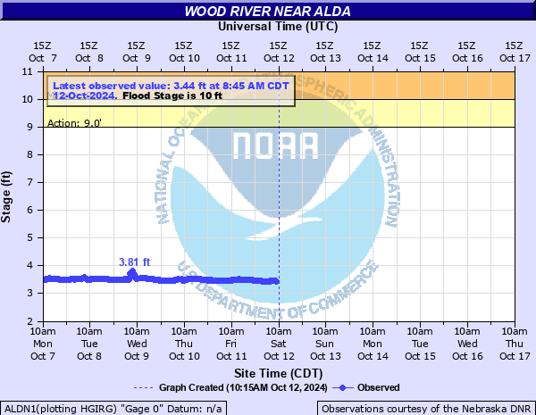
Wood River near Alda
Critical Stages
9' - Action
10' - Flood
11' - Moderate
12.2' - Major
Latest Observation
Updated: 7:45 PM CST 12/15/25
Status: No Flooding
Stage: 3.47 ft
Flow: -999 kcfs
Forecast
Forecast not available for this location.
| Time | Stage (ft) | Flow (kcfs) |
|---|---|---|
| 7:45 PM 12/15 | 3.47 | -999 |
| 7:30 PM 12/15 | 3.47 | -999 |
| 7:15 PM 12/15 | 3.47 | -999 |
| 7:00 PM 12/15 | 3.46 | -999 |
| 6:45 PM 12/15 | 3.46 | -999 |
| 6:30 PM 12/15 | 3.46 | -999 |
| 6:15 PM 12/15 | 3.45 | -999 |
| 6:00 PM 12/15 | 3.45 | -999 |
| 5:45 PM 12/15 | 3.43 | -999 |
| 5:30 PM 12/15 | 3.42 | -999 |
| 5:15 PM 12/15 | 3.4 | -999 |
| 5:00 PM 12/15 | 3.39 | -999 |
| 4:45 PM 12/15 | 3.4 | -999 |
| 4:30 PM 12/15 | 3.42 | -999 |
| 4:15 PM 12/15 | 3.42 | -999 |
| 4:00 PM 12/15 | 3.43 | -999 |
| 3:45 PM 12/15 | 3.43 | -999 |
| 3:30 PM 12/15 | 3.43 | -999 |
| 3:15 PM 12/15 | 3.43 | -999 |
| 3:00 PM 12/15 | 3.43 | -999 |
| 2:45 PM 12/15 | 3.43 | -999 |
| 2:30 PM 12/15 | 3.44 | -999 |
| 2:15 PM 12/15 | 3.45 | -999 |
| 2:00 PM 12/15 | 3.47 | -999 |
| 1:45 PM 12/15 | 3.49 | -999 |
| 1:30 PM 12/15 | 3.5 | -999 |
| 1:15 PM 12/15 | 3.5 | -999 |
| 1:00 PM 12/15 | 3.5 | -999 |
| 12:45 PM 12/15 | 3.5 | -999 |
| 12:30 PM 12/15 | 3.5 | -999 |
14' -
Water will reach the bottom of the bridge at the river gauge site on Alda road.
13' -
Water will begin to flow across Nebraska 40 Link C also known as Alda Road about one quarter mile south of the gauge. Water will also begin to flow over Highway 30 west of Alda.
12' -
There is extensive flooding upstream of the gauge in the town of Wood River where houses on the north side of town will begin to flood.
11' -
The left bank overflows, and water floods lowlands and country roads.
10' -
Minor lowland flooding occurs in pastures and farm lands.
| Date | Stage (ft) |
|---|---|
| Jun 16, 1967 | 13.96 |
| May 12, 2005 | 13.85 |
| Mar 16, 2019 | 13.61 |
| Mar 12, 1993 | 13.55 |
| Mar 21, 1969 | 13.39 |
| Jun 26, 1968 | 13.19 |
| Jul 3, 1965 | 12.8 |
| Mar 29, 1960 | 12.69 |
| Mar 15, 1978 | 12.66 |
| May 29, 1965 | 12.57 |
| Jul 25, 1958 | 12.57 |
| Jun 8, 2008 | 12.47 |
| Jun 11, 1994 | 12.06 |
| May 24, 1998 | 11.99 |
| Sep 17, 1985 | 11.96 |
| Feb 14, 1966 | 11.93 |
| Jun 18, 1996 | 11.84 |
| Feb 23, 2007 | 11.83 |
| Jul 8, 1984 | 11.79 |
| Jun 1, 1991 | 11.76 |
Data provided by the National Weather Service.