« Back to Madison County Rivers
Fenholloway River near Foley (US 27)
Critical Stages
63' - Action
65' - Flood
67' - Moderate
68' - Major
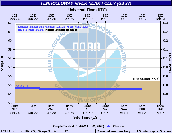
Latest Observation
Updated: 6:45 PM EST 12/15/25
Status: Low Threshold
Stage: 54.71 ft
Flow: 0.003 kcfs
Forecast
Forecast not available for this location.
| Time | Stage (ft) | Flow (kcfs) |
|---|---|---|
| 6:45 PM 12/15 | 54.71 | 0.003 |
| 6:30 PM 12/15 | 54.72 | 0.003 |
| 6:15 PM 12/15 | 54.72 | 0.003 |
| 6:00 PM 12/15 | 54.72 | 0.003 |
| 5:45 PM 12/15 | 54.72 | 0.003 |
| 5:30 PM 12/15 | 54.72 | 0.003 |
| 5:15 PM 12/15 | 54.72 | 0.003 |
| 5:00 PM 12/15 | 54.72 | 0.003 |
| 4:45 PM 12/15 | 54.72 | 0.003 |
| 4:30 PM 12/15 | 54.72 | 0.003 |
| 4:15 PM 12/15 | 54.72 | 0.003 |
| 4:00 PM 12/15 | 54.73 | 0.003 |
| 3:45 PM 12/15 | 54.73 | 0.003 |
| 3:30 PM 12/15 | 54.73 | 0.003 |
| 3:15 PM 12/15 | 54.73 | 0.003 |
| 3:00 PM 12/15 | 54.73 | 0.003 |
| 2:45 PM 12/15 | 54.73 | 0.003 |
| 2:30 PM 12/15 | 54.73 | 0.003 |
| 2:15 PM 12/15 | 54.73 | 0.003 |
| 2:00 PM 12/15 | 54.73 | 0.003 |
| 1:45 PM 12/15 | 54.73 | 0.003 |
| 1:30 PM 12/15 | 54.73 | 0.003 |
| 1:15 PM 12/15 | 54.73 | 0.003 |
| 1:00 PM 12/15 | 54.73 | 0.003 |
| 12:45 PM 12/15 | 54.73 | 0.003 |
| 12:30 PM 12/15 | 54.73 | 0.003 |
| 12:15 PM 12/15 | 54.73 | 0.003 |
| 12:00 PM 12/15 | 54.73 | 0.003 |
| 11:45 AM 12/15 | 54.73 | 0.003 |
| 11:30 AM 12/15 | 54.73 | 0.003 |
No flood impact data available for this location.
| Date | Stage (ft) |
|---|---|
| Sep 12, 1964 | 68.15 |
| Aug 14, 1970 | 67.31 |
| Jun 9, 1957 | 67.02 |
| Oct 2, 1957 | 66.36 |
| Apr 4, 1973 | 65.77 |
| Mar 9, 2003 | 65.77 |
| Mar 3, 1991 | 65.54 |
| Apr 8, 2014 | 65.44 |
| Mar 17, 1959 | 65.09 |
| Jul 28, 1982 | 65.08 |
| Apr 19, 2014 | 64.98 |
| Feb 23, 1998 | 64.91 |
| Sep 9, 1966 | 64.91 |
| Jul 26, 1980 | 64.9 |
| Sep 1, 1985 | 64.9 |
| Sep 27, 2004 | 64.83 |
| Sep 28, 1960 | 64.69 |
| Oct 8, 1960 | 64.61 |
| Aug 22, 2012 | 64.28 |
| Apr 2, 2005 | 64.26 |
Data provided by the National Weather Service.