« Back to Madison County Rivers
Aucilla River near Nutall Rise (in MHHW)
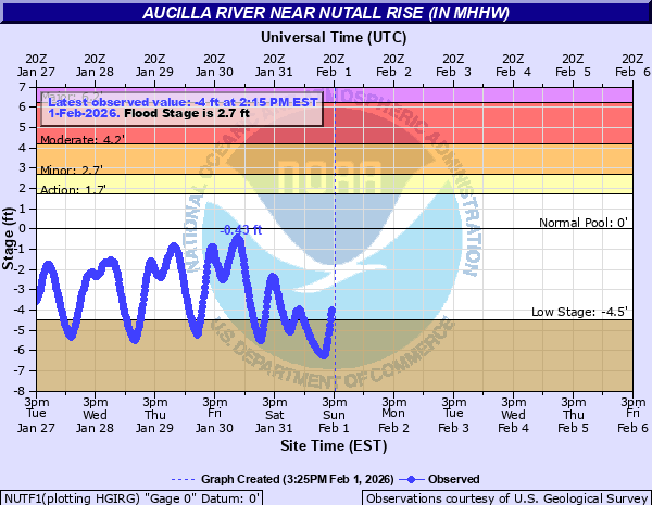
Critical Stages
1.7' - Action
2.7' - Flood
4.2' - Moderate
6.2' - Major
Latest Observation
Updated: 7:15 PM EST 12/15/25
Status: No Flooding
Stage: -2.51 ft
Flow: -999 kcfs
Forecast
Forecast not available for this location.
| Time | Stage (ft) | Flow (kcfs) |
|---|---|---|
| 7:15 PM 12/15 | -2.51 | -999 |
| 7:00 PM 12/15 | -2.55 | -999 |
| 6:45 PM 12/15 | -2.61 | -999 |
| 6:30 PM 12/15 | -2.66 | -999 |
| 6:15 PM 12/15 | -2.77 | -999 |
| 6:00 PM 12/15 | -2.86 | -999 |
| 5:45 PM 12/15 | -2.92 | -999 |
| 5:30 PM 12/15 | -2.92 | -999 |
| 5:15 PM 12/15 | -2.95 | -999 |
| 5:00 PM 12/15 | -2.98 | -999 |
| 4:45 PM 12/15 | -2.99 | -999 |
| 4:30 PM 12/15 | -3 | -999 |
| 4:15 PM 12/15 | -3 | -999 |
| 4:00 PM 12/15 | -3 | -999 |
| 3:45 PM 12/15 | -2.99 | -999 |
| 3:30 PM 12/15 | -2.96 | -999 |
| 3:15 PM 12/15 | -2.92 | -999 |
| 3:00 PM 12/15 | -2.87 | -999 |
| 2:45 PM 12/15 | -2.84 | -999 |
| 2:30 PM 12/15 | -2.8 | -999 |
| 2:15 PM 12/15 | -2.75 | -999 |
| 2:00 PM 12/15 | -2.7 | -999 |
| 1:45 PM 12/15 | -2.71 | -999 |
| 1:30 PM 12/15 | -2.72 | -999 |
| 1:15 PM 12/15 | -2.79 | -999 |
| 1:00 PM 12/15 | -2.84 | -999 |
| 12:45 PM 12/15 | -2.91 | -999 |
| 12:30 PM 12/15 | -3.04 | -999 |
| 12:15 PM 12/15 | -3.17 | -999 |
| 12:00 PM 12/15 | -3.31 | -999 |
12' -
Flooding of historic proportions affecting Southern Jefferson and Southwestern Taylor Counties. Areas up to 15 miles inland from the Gulf of Mexico west of the Econfina River are flooded. Water reaches the base of the US-98 bridge over Aucilla.
9' -
Catastrophic flooding affecting Southern Jefferson and Southwestern Taylor Counties. Numerous homes not elevated in the area likely destroyed by flood waters. Flooding waters could reach Rattlesnake Grade Rd. in Taylor County limiting travel along that road. The east and west approach of the US-98 bridge over the Aucilla River are flooded by over a foot and is subject to closer.
7.5' -
US-98 floods in several places in Taylor and Jefferson Counties. Residences not elevated near, or just east of Aucilla Landing Rd. will experience flooding by 3 to 4 feet. Further south, residences along County Road 690-A could see flooding up to 8 ft.
6.2' -
Significant flooding along the tidal portion of the Aucilla and Econfina Rivers. Roadways from Nutall Rise south to Mandalay and from US-98 to Econfina State Park are flooded, with the exception of US-98. Homes not elevated in these areas experience significant flooding.
4.2' -
Most homes are completely surrounded by water in Mandalay. Homes in Nutall Rise not elevated begin to flood. In Econfina State Park, homes not elevated are flooded. County Roads 690 and 685 are flooded and homes on riverside become inaccessible by motor vehicle.
3.7' -
Water begins to surround homes in Mandalay. Homes not on stilts may flood. Flooding begins at Nutall Rise affecting homes not elevated immediately along the river. At Econfina State Park, much of the area south of Tedder Drive is flooded, restricting access to the area.
2.7' -
Water begins to flood yards of homes near the river in Mandalay and Nutall Rise. Access into the area on County Road 690 and Mandalay Road in Taylor County becomes restricted. Flooding begins to affect Econfina State Park.
1.7' -
The Mandalay Bay Boat Ramp and the Econfina State Park Boat Ramp flood at this level.
| Date | Stage (ft) |
|---|---|
| Oct 10, 2018 | 7.31 |
| Sep 16, 2020 | 6.18 |
| Sep 2, 2016 | 6.07 |
| Sep 27, 2024 | 5.86 |
| Sep 1, 2008 | 5.45 |
| Sep 15, 2004 | 3.92 |
| Aug 11, 2011 | 3.73 |
| Apr 26, 2005 | 3.6 |
| Aug 30, 2023 | 3.36 |
| Jun 6, 2016 | 2.55 |
| Oct 8, 2017 | 2.44 |
| May 28, 2018 | 2.27 |
| Jan 3, 2022 | 2.2 |
| Dec 21, 2018 | 2.12 |
| Feb 24, 2016 | 2.02 |
| Jan 15, 2016 | 1.88 |
| Oct 27, 2015 | 1.61 |
Data provided by the National Weather Service.