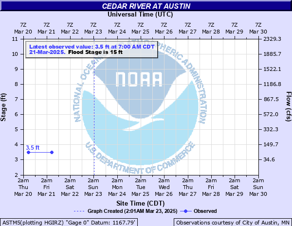
Cedar River at Austin
Critical Stages
12' - Action
15' - Flood
18' - Moderate
20' - Major
Latest Observation
Updated: 7:00 AM CST 12/15/25
Status: No Flooding
Stage: 3.4 ft
Flow: 0.071 kcfs
Forecast
Forecast not available for this location.
| Time | Stage (ft) | Flow (kcfs) |
|---|---|---|
| 7:00 AM 12/15 | 3.4 | 0.071 |
| 7:00 AM 12/14 | 3.4 | 0.071 |
| 7:00 AM 12/13 | 3.4 | 0.071 |
| 7:00 AM 12/12 | 3.4 | 0.071 |
| 7:00 AM 12/11 | 3.4 | 0.071 |
| 7:00 AM 12/10 | 3.4 | 0.071 |
| 7:00 AM 12/9 | 3.4 | 0.071 |
| 7:00 AM 12/8 | 3.6 | 0.094 |
| 7:00 AM 12/7 | 3.5 | 0.082 |
| 7:00 AM 12/6 | 3.5 | 0.082 |
| 7:00 AM 12/5 | 3.5 | 0.082 |
| 7:00 AM 12/4 | 3.4 | 0.071 |
| 7:00 AM 12/3 | 3.4 | 0.071 |
| 7:00 AM 12/2 | 3.4 | 0.071 |
| 7:00 AM 12/1 | 3.4 | 0.071 |
| 7:00 AM 11/30 | 3.4 | 0.071 |
| 7:00 AM 11/29 | 3.5 | 0.082 |
| 7:00 AM 11/28 | 3.4 | 0.071 |
| 7:00 AM 11/27 | 3.5 | 0.082 |
| 7:00 AM 11/26 | 3.5 | 0.082 |
| 7:00 AM 11/25 | 3.4 | 0.071 |
| 7:00 AM 11/24 | 3.4 | 0.071 |
| 7:00 AM 11/23 | 3.4 | 0.071 |
| 7:00 AM 11/22 | 3.4 | 0.071 |
| 7:00 AM 11/21 | 3.4 | 0.071 |
| 7:00 AM 11/20 | 3.5 | 0.082 |
| 7:00 AM 11/19 | 3.5 | 0.082 |
| 7:00 AM 11/18 | 3.6 | 0.094 |
| 7:00 AM 11/17 | 3.4 | 0.071 |
| 7:00 AM 11/16 | 3.4 | 0.071 |
26' -
The protective dike is overtopped.
20' -
Serious flooding is likely.
18' -
Numerous homes and businesses may be threatened by high water.
15' -
The city of Austin takes specific actions to warn people and businesses.
12' -
Water begins to impact Driesner Park.
| Date | Stage (ft) |
|---|---|
| Sep 16, 2004 | 25 |
| Jul 10, 2000 | 23.4 |
| Jun 12, 2008 | 22.4 |
| Jul 17, 1978 | 21.9 |
| Aug 15, 1993 | 21.3 |
| Jun 22, 2024 | 20.7 |
| Sep 24, 2010 | 20.6 |
| Sep 23, 2016 | 19.8 |
| Jun 17, 1976 | 19.1 |
| Jul 2, 1983 | 18.2 |
| Mar 26, 1950 | 17.8 |
| Jul 12, 2000 | 17.59 |
| Jun 1, 2000 | 17.5 |
| May 18, 2000 | 17.4 |
| Mar 29, 1962 | 17.2 |
| Mar 26, 1961 | 17 |
| Apr 12, 2001 | 16.8 |
| Apr 4, 1990 | 16.8 |
| Mar 15, 1945 | 16.6 |
| Apr 7, 2001 | 16.2 |
Data provided by the National Weather Service.