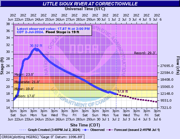
Little Sioux River at Correctionville
Critical Stages
17' - Action
19' - Flood
21' - Moderate
23' - Major
Latest Observation
Updated: 9:00 PM CST 12/15/25
Status: No Flooding
Stage: 5.1 ft
Flow: 0.422 kcfs
Forecast
Forecast not available for this location.
| Time | Stage (ft) | Flow (kcfs) |
|---|---|---|
| 9:00 PM 12/15 | 5.1 | 0.422 |
| 8:45 PM 12/15 | 5.1 | 0.422 |
| 8:30 PM 12/15 | 5.1 | 0.422 |
| 8:15 PM 12/15 | 5.1 | 0.422 |
| 8:00 PM 12/15 | 5.11 | 0.428 |
| 7:45 PM 12/15 | 5.11 | 0.428 |
| 7:30 PM 12/15 | 5.11 | 0.428 |
| 7:15 PM 12/15 | 5.11 | 0.428 |
| 7:00 PM 12/15 | 5.11 | 0.428 |
| 6:45 PM 12/15 | 5.11 | 0.428 |
| 6:30 PM 12/15 | 5.11 | 0.428 |
| 6:15 PM 12/15 | 5.11 | 0.428 |
| 6:00 PM 12/15 | 5.12 | 0.433 |
| 5:45 PM 12/15 | 5.11 | 0.428 |
| 5:30 PM 12/15 | 5.11 | 0.428 |
| 5:15 PM 12/15 | 5.11 | 0.428 |
| 5:00 PM 12/15 | 5.11 | 0.428 |
| 4:45 PM 12/15 | 5.11 | 0.428 |
| 4:30 PM 12/15 | 5.11 | 0.428 |
| 4:15 PM 12/15 | 5.11 | 0.428 |
| 4:00 PM 12/15 | 5.11 | 0.428 |
| 3:45 PM 12/15 | 5.11 | 0.428 |
| 3:30 PM 12/15 | 5.11 | 0.428 |
| 3:15 PM 12/15 | 5.11 | 0.428 |
| 3:00 PM 12/15 | 5.11 | 0.428 |
| 2:45 PM 12/15 | 5.11 | 0.428 |
| 2:30 PM 12/15 | 5.11 | 0.428 |
| 2:15 PM 12/15 | 5.1 | 0.422 |
| 2:00 PM 12/15 | 5.1 | 0.422 |
| 1:45 PM 12/15 | 5.09 | 0.416 |
32' -
A more substantial risk to flooding of homes and businesses begins along the eastern edges of Anthon.
30' -
Several structures on the northwest side of Correctionville are flooded.
29' -
Hwy 31 north of Anthon is flooded and the intersection of 220th and Mason Ave east of Anthon may also be flooded. Much of Stahls Park in Anthon is flooded.
28' -
The lowest portions of Hwy 20 just west of Correctionville flood and may result in a closure.
26' -
The bridge on County Road L36 northwest of Correctionville is overtopped.
23.5' -
The water reaches the bottom of the bridge on County Road L36 northwest of Correctionville, the southern portions of Correctionville will be significantly affected by flooding, and many sewers, homes, and roads will be flooded.
23' -
Iowa Highway 31 both north and south of Correctionville is flooded. More substatial overtopping of levees also begins. If Bacon Creek between Correctionville and Cushing is also running high, water will begin backing up Bacon Creek and flood the southern portions of Correctionville along and north of County Road D22. Water reaches to the top of the boat ramp at Stahls Park in Anthon and begins to flood the parking lot.
21' -
Water approaches Aspen St on the west side of Correctionville. Much of Copeland Park is underwater.
19' -
More significant amounts of agricultural land are flooded. Copeland Park west of Correctionville floods.
17' -
The lowest portions of Copeland Park in Correctionville may begin to flood.
16' -
Minor flooding of some of the low lying agricultural lands.
14' -
The boat ramp parking lot at Little Sioux Park between Correctionville and Anthon floods.
| Date | Stage (ft) |
|---|---|
| Jun 24, 2024 | 30.92 |
| Jun 23, 1891 | 29.34 |
| Mar 15, 2019 | 26.45 |
| Apr 7, 1965 | 25.86 |
| May 28, 2013 | 25.35 |
| Jun 20, 2014 | 24.39 |
| Sep 24, 2018 | 24.3 |
| Jul 18, 1993 | 23.82 |
| Jun 28, 2010 | 23.79 |
| Apr 8, 1969 | 23.61 |
| Jun 21, 1954 | 23.36 |
| Jun 18, 1984 | 23.28 |
| Mar 30, 1962 | 23.14 |
| Apr 7, 1951 | 22.58 |
| Mar 29, 1960 | 22.57 |
| Mar 29, 1961 | 22.32 |
| Feb 20, 1971 | 22.23 |
| Mar 24, 1979 | 22.13 |
| Jun 12, 1953 | 22.09 |
| Jun 22, 1983 | 22.06 |
Data provided by the National Weather Service.