Choctawhatchee River at Geneva (SR 52)
Critical Stages
18' - Action
23' - Flood
30' - Moderate
36' - Major
Latest Observation
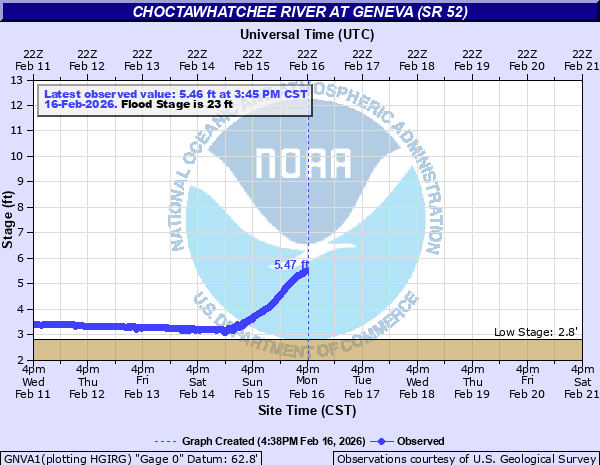
Updated: 7:00 PM CST 12/7/25
Status: No Flooding
Stage: 5.36 ft
Flow: -999 kcfs
Forecast
Forecast not available for this location.
| Time | Stage (ft) | Flow (kcfs) |
|---|---|---|
| 7:00 PM 12/7 | 5.36 | -999 |
| 6:00 PM 12/7 | 5.39 | -999 |
| 5:00 PM 12/7 | 5.43 | -999 |
| 4:00 PM 12/7 | 5.47 | -999 |
| 3:00 PM 12/7 | 5.5 | -999 |
| 2:00 PM 12/7 | 5.55 | -999 |
| 1:00 PM 12/7 | 5.53 | -999 |
| 12:00 PM 12/7 | 5.54 | -999 |
| 11:00 AM 12/7 | 5.58 | -999 |
| 10:00 AM 12/7 | 5.62 | -999 |
| 9:00 AM 12/7 | 5.65 | -999 |
| 8:00 AM 12/7 | 5.73 | -999 |
| 7:00 AM 12/7 | 5.75 | -999 |
| 6:00 AM 12/7 | 5.76 | -999 |
| 5:00 AM 12/7 | 5.77 | -999 |
| 4:00 AM 12/7 | 5.77 | -999 |
| 3:00 AM 12/7 | 5.77 | -999 |
| 2:00 AM 12/7 | 5.78 | -999 |
| 1:00 AM 12/7 | 5.77 | -999 |
| 12:00 AM 12/7 | 5.76 | -999 |
| 11:00 PM 12/6 | 5.75 | -999 |
| 10:00 PM 12/6 | 5.74 | -999 |
| 9:00 PM 12/6 | 5.73 | -999 |
| 8:00 PM 12/6 | 5.73 | -999 |
| 7:00 PM 12/6 | 5.73 | -999 |
| 6:00 PM 12/6 | 5.72 | -999 |
| 5:00 PM 12/6 | 5.72 | -999 |
| 4:00 PM 12/6 | 5.65 | -999 |
| 3:00 PM 12/6 | 5.68 | -999 |
| 2:00 PM 12/6 | 5.72 | -999 |
53' -
Flood water will be on the Pea River Bridge.
50' -
Flood water will rise to the state highway 52 bridge.
48' -
Flood water reaches the minimum elevation of the levee.
47' -
About 125 homes outside the levee will be flooded.
43' -
Highway 27 between the Pea River and the levee will start to flood.
42' -
Water will rise to the school on West Mulkey Avenue. Highway 52 will start to flood.
38' -
Highway 27 northeast of the city will start to flood.
34' -
More extensive flooding will occur outside the levee. Numerous evacuations will be required.
30' -
About 30 homes outside the levee will flood.
27' -
Farmlands and some farm roads will flood.
25' -
Homes along East Westville Avenue will begin to flood. Fowler Park will start to flood.
23' -
Minor lowland flooding begins.
| Date | Stage (ft) |
|---|---|
| Mar 16, 1929 | 46.9 |
| Jul 8, 1994 | 42.42 |
| Mar 19, 1990 | 38.54 |
| Mar 10, 1998 | 35.87 |
| Apr 11, 1975 | 34.36 |
| Mar 30, 2009 | 33.12 |
| Sep 3, 1937 | 31.6 |
| Jan 29, 1978 | 31 |
| Dec 28, 2015 | 30.22 |
| Apr 6, 1960 | 29.7 |
| Sep 18, 2020 | 28.81 |
| Sep 18, 2020 | 28.81 |
| Apr 20, 2014 | 28.15 |
| Apr 3, 2016 | 27.98 |
| Mar 5, 1991 | 26.61 |
| Jan 4, 2017 | 26.6 |
| Jan 4, 2016 | 26.6 |
| May 2, 2014 | 26.08 |
| Feb 13, 2013 | 25.97 |
| Nov 10, 1989 | 25.6 |
Data provided by the National Weather Service.