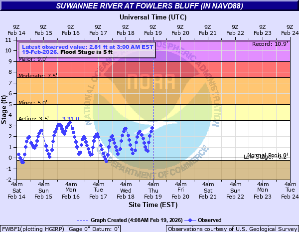
Suwannee River at Fowlers Bluff (in NAVD88)
Critical Stages
3.5' - Action
5' - Flood
7.5' - Moderate
9' - Major
Latest Observation
Updated: 5:00 AM EST 12/16/25
Status: Low Threshold
Stage: -0.89 ft
Flow: -999 kcfs
Forecast
Forecast not available for this location.
| Time | Stage (ft) | Flow (kcfs) |
|---|---|---|
| 5:00 AM 12/16 | -0.89 | -999 |
| 4:00 AM 12/16 | -0.63 | -999 |
| 3:00 AM 12/16 | -0.33 | -999 |
| 2:00 AM 12/16 | -0.05 | -999 |
| 12:00 AM 12/16 | 0.37 | -999 |
| 11:00 PM 12/15 | 0.39 | -999 |
| 10:00 PM 12/15 | 0.24 | -999 |
| 9:00 PM 12/15 | -0.03 | -999 |
| 8:00 PM 12/15 | -0.23 | -999 |
| 7:00 PM 12/15 | -0.32 | -999 |
| 6:00 PM 12/15 | -0.53 | -999 |
| 5:00 PM 12/15 | -0.66 | -999 |
| 4:00 PM 12/15 | -0.57 | -999 |
| 3:00 PM 12/15 | -0.58 | -999 |
| 1:00 PM 12/15 | -1.02 | -999 |
| 12:00 PM 12/15 | -1.6 | -999 |
| 10:00 AM 12/15 | -1.75 | -999 |
| 7:00 AM 12/15 | -1.48 | -999 |
| 6:00 AM 12/15 | -1.34 | -999 |
| 4:00 AM 12/15 | -1.03 | -999 |
| 2:00 AM 12/15 | -0.55 | -999 |
| 1:00 AM 12/15 | -0.24 | -999 |
| 12:00 AM 12/15 | 0.01 | -999 |
| 11:00 PM 12/14 | 0.21 | -999 |
| 10:00 PM 12/14 | 0.39 | -999 |
| 9:00 PM 12/14 | 0.53 | -999 |
| 8:00 PM 12/14 | 0.42 | -999 |
| 7:00 PM 12/14 | 0.45 | -999 |
| 6:00 PM 12/14 | 0.38 | -999 |
| 5:00 PM 12/14 | 0.37 | -999 |
11' -
Historic flooding in Fowlers Bluff. All land areas in town are flooded, some ares several feet deep.
10' -
Catastrophic flooding continues in Fowlers Bluff. Nearly all land areas in town are flooded. Cedar Key National Wildlife Refuge buildings off NW 31 place flood. In Dixie County, SE Highway 349 is impassible in the vicinity of the Keen Cemetery.
9' -
In Fowlers Bluff, water spreads across NW 46th lane, flooding areas west of Highway NW 347. Most homes not elevated along the river experience significant flooding. In Dixie County, SE Highway 349 begins to flood near the Keen Cemetery.
7.5' -
In Fowlers Bluff, NW 46th Lane is impassible west of the Treasure Camp Boat Ramp. Homes not elevated along this road experience significant flooding. Flooding worsens along NW 154th Avenue and NW 153 Court.
6' -
In Fowlers Bluff, NW 46th Lane is mostly flooded west of the Treasure Camp Boat Ramp. Homes along NW 46th lane not elevated in this area are prone to flooding. Water begins to affect homes along NW 154th Avenue and NW 153rd Court.
5' -
In Fowlers Bluff, water moves into yards of homes along NW 46th lane and begins to cover the road in some areas west of the Treasure Camp Boat Ramp.
4.5' -
In Fowlers Bluff, this is the top of the bank along the riverfront.
| Date | Stage (ft) |
|---|---|
| Apr 14, 1948 | 10.9 |
| Apr 21, 1973 | 8.9 |
| Sep 27, 2024 | 6.69 |
| Sep 2, 2016 | 6.54 |
| May 4, 2014 | 6.35 |
| Jan 5, 2019 | 5.12 |
| Dec 21, 2018 | 5.07 |
| Aug 5, 2024 | 5.03 |
| Jun 6, 2016 | 4.29 |
Data provided by the National Weather Service.