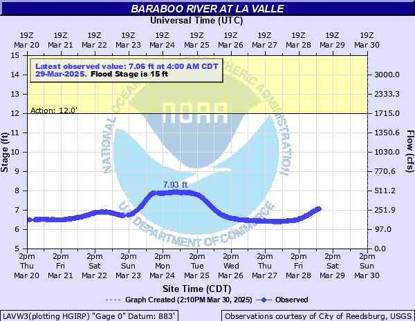
Baraboo River at La Valle
Critical Stages
12' - Action
15' - Flood
17' - Moderate
19' - Major
Latest Observation
Updated: 3:00 AM CST 12/7/25
Status: No Flooding
Stage: 5.94 ft
Flow: 0.0887 kcfs
Forecast
Forecast not available for this location.
| Time | Stage (ft) | Flow (kcfs) |
|---|---|---|
| 3:00 AM 12/7 | 5.94 | 0.0887 |
| 2:45 AM 12/7 | 5.95 | 0.0899 |
| 2:30 AM 12/7 | 5.94 | 0.0887 |
| 2:15 AM 12/7 | 5.96 | 0.0912 |
| 2:00 AM 12/7 | 5.96 | 0.0912 |
| 1:45 AM 12/7 | 5.95 | 0.0899 |
| 1:30 AM 12/7 | 5.94 | 0.0887 |
| 1:15 AM 12/7 | 5.96 | 0.0912 |
| 1:00 AM 12/7 | 5.96 | 0.0912 |
| 12:45 AM 12/7 | 5.95 | 0.0899 |
| 12:30 AM 12/7 | 5.95 | 0.0899 |
| 12:15 AM 12/7 | 5.96 | 0.0912 |
| 12:00 AM 12/7 | 5.94 | 0.0887 |
| 11:45 PM 12/6 | 5.94 | 0.0887 |
| 11:30 PM 12/6 | 5.96 | 0.0912 |
| 11:15 PM 12/6 | 5.95 | 0.0899 |
| 11:00 PM 12/6 | 5.96 | 0.0912 |
| 10:45 PM 12/6 | 5.95 | 0.0899 |
| 10:30 PM 12/6 | 5.96 | 0.0912 |
| 10:15 PM 12/6 | 5.94 | 0.0887 |
| 10:00 PM 12/6 | 5.95 | 0.0899 |
| 9:45 PM 12/6 | 5.94 | 0.0887 |
| 9:30 PM 12/6 | 5.95 | 0.0899 |
| 9:15 PM 12/6 | 5.96 | 0.0912 |
| 9:00 PM 12/6 | 5.96 | 0.0912 |
| 8:45 PM 12/6 | 5.96 | 0.0912 |
| 8:30 PM 12/6 | 5.96 | 0.0912 |
| 8:15 PM 12/6 | 5.95 | 0.0899 |
| 8:00 PM 12/6 | 5.96 | 0.0912 |
| 7:45 PM 12/6 | 5.96 | 0.0912 |
23' -
Center St Bridge is covered. Water is several feet deep across most of downtown. Water extends to Hwy 58 impacting many buildings in downtown.
22' -
Center St bridge is covered. Floodwaters are about 4 feet deep around W Main St and Center St. Water covers the road past the 400 State Trail and is in the first floor or many buildings east of the trail, including South St.
20' -
Floodwaters have spread into downtown La Valle and are about 2 feet deep around W Main St and Center Rd. Water extends to the 400 State Trail. Many businesses/homes along Commercial St and E and W Main St along the river have water in the first floor.
19' -
Floodwaters get into the basement of a some homes/businesses on West Main St. Water is 1-2 ft deep near W Main St and Center St, impacting the first floors of several businesses. The 400 State Trail and homes along South St. may be impacted.
18' -
Floodwaters get close to buildings around W Main St, Commercial St, and Center St. The 400 State Trail may be impacted by water. Water gets into the basement of some buildings/homes on W Main St.
15' -
Between stages 12 feet and 18 feet, there is lowland flooding in the La Valle area.
12' -
There is minor lowland flooding in the La Valle area.
| Date | Stage (ft) |
|---|---|
| Jun 10, 2008 | 23.23 |
| Aug 29, 2018 | 22.55 |
| Sep 5, 2018 | 18.09 |
| Sep 5, 2018 | 17.73 |
| Sep 8, 2016 | 17 |
| Jul 22, 2017 | 14.88 |
| Mar 15, 2007 | 14 |
| Jul 16, 2010 | 14 |
| May 5, 2018 | 13.19 |
| Aug 19, 2007 | 13 |
| Mar 23, 2011 | 12 |
| May 23, 2004 | 12 |
| Oct 23, 2020 | 11.7 |
| Oct 2, 2019 | 11.67 |
| Oct 11, 2018 | 11.57 |
| May 22, 2024 | 11.38 |
| Apr 26, 2008 | 11 |
| Jul 12, 2008 | 11 |
| Mar 7, 2004 | 11 |
| Jul 20, 2019 | 10.55 |
Data provided by the National Weather Service.