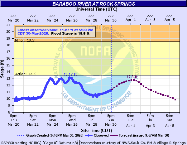
Baraboo River at Rock Springs
Critical Stages
13.5' - Action
18.5' - Flood
21' - Moderate
23' - Major
Latest Observation
Updated: 3:00 AM CST 12/7/25
Status: No Flooding
Stage: 8.48 ft
Flow: 0.133 kcfs
Forecast
Forecast not available for this location.
| Time | Stage (ft) | Flow (kcfs) |
|---|---|---|
| 3:00 AM 12/7 | 8.48 | 0.133 |
| 2:45 AM 12/7 | 8.4 | 0.12 |
| 2:30 AM 12/7 | 8.37 | 0.116 |
| 2:15 AM 12/7 | 8.48 | 0.133 |
| 2:00 AM 12/7 | 8.78 | 0.167 |
| 1:45 AM 12/7 | 8.74 | 0.162 |
| 1:30 AM 12/7 | 8.62 | 0.149 |
| 1:15 AM 12/7 | 8.42 | 0.123 |
| 1:00 AM 12/7 | 8.89 | 0.181 |
| 12:45 AM 12/7 | 8.92 | 0.184 |
| 12:30 AM 12/7 | 8.61 | 0.148 |
| 12:15 AM 12/7 | 8.52 | 0.138 |
| 12:00 AM 12/7 | 8.39 | 0.119 |
| 11:45 PM 12/6 | 8.51 | 0.137 |
| 11:30 PM 12/6 | 8.38 | 0.117 |
| 11:15 PM 12/6 | 8.94 | 0.187 |
| 11:00 PM 12/6 | 8.89 | 0.181 |
| 10:45 PM 12/6 | 8.44 | 0.126 |
| 10:30 PM 12/6 | 8.61 | 0.148 |
| 10:15 PM 12/6 | 8.89 | 0.181 |
| 10:00 PM 12/6 | 8.33 | 0.11 |
| 9:45 PM 12/6 | 8.53 | 0.139 |
| 9:30 PM 12/6 | 8.64 | 0.151 |
| 9:15 PM 12/6 | 8.57 | 0.143 |
| 9:00 PM 12/6 | 8.53 | 0.139 |
| 8:45 PM 12/6 | 8.42 | 0.123 |
| 8:30 PM 12/6 | 8.38 | 0.117 |
| 8:15 PM 12/6 | 8.36 | 0.114 |
| 8:00 PM 12/6 | 8.5 | 0.136 |
| 7:45 PM 12/6 | 8.41 | 0.122 |
28.5' -
Water about 5 feet deep over Highways DD, 154 and 136 and Elm St, 2nd St, 1st St, River St, and Ash St. Busser Park along Highway 136 and the baseball diamond in Fireman's Park along Highway DD are covered with water 5 feet deep. Floodwaters are up to or over first floor windows of some businesses, including the Post Office, along Highway 154 near the river.
27' -
Water about 3-4 feet deep over Highways DD, 154 and 136 and Elm St, 2nd St, 1st St, River St and Ash St. Busser Park along Highway 136 and the baseball diamond in Fireman's Park along Highway DD are covered with water 3-4 feet deep. Floodwaters impact the first floor of some businesses, including the Post Office, along Highway 154 near the river.
25' -
Water about 2-3 feet deep over Highways DD, 154 and 136 and Elm St, 2nd St, 1st St, River St and Ash St. Busser Park along Highway 136 and the baseball diamond in Fireman's Park along Highway DD are covered with water about 2 feet deep. Floodwaters are up to or impact the first floor of some businesses, including the Post Office, along Highway 154 near the river.
23' -
Floodwaters touch the base of the river gauge house in Rock Springs. Floodwaters cover much of Highways DD and 136 and is up to the centerline on 154. Water affects some businesses, including the Post Office, along Hwy 154. Busser Park along Highway 136 and the baseball diamond in Fireman's Park along Highway DD are covered with 3-4 ft of water.
22' -
Floodwaters affect the edges of Highways DD, 154 and 136 in Rock Springs as well as Busser Park along Highway 136. Water is about 3 feet deep in the baseball diamond in Fireman's Park along Highway DD. Floodwaters affect some businesses, including the Post Office, on Highway 154 in Rock Springs.
21' -
Floodwaters are about 2 feet deep in the baseball diamond in Fireman's Park along Highway DD. Water is over portions of Highways DD, 154 and 136 in Rock Springs.
20' -
Floodwaters are about 1 foot deep in the baseball diamond in Fireman's Park along Highway DD. Water is over portions of Highway DD in Rock Springs.
19' -
The river is well out of its banks and floodwaters affect a low spot on Highway DD in Rock Springs. Farm fields are flooded in the Loganville area.
17' -
Farm fields adjacent to the river are flooded in the Loganville area.
16' -
There is minor lowland flooding in the Rock Springs area.
14' -
There is minor lowland flooding in the Rock Springs area.
13.5' -
There is minor lowland flooding in the Rock Springs area.
| Date | Stage (ft) |
|---|---|
| Jun 11, 2008 | 28.73 |
| Aug 31, 2018 | 27.6 |
| Sep 6, 2018 | 26.4 |
| Sep 25, 2016 | 22.6 |
| Mar 15, 2019 | 22.17 |
| Jun 2, 2000 | 21.71 |
| Jul 24, 2017 | 21.57 |
| Aug 21, 2007 | 21.37 |
| May 25, 2004 | 20.99 |
| Sep 10, 2016 | 20.67 |
| Jul 12, 2008 | 20.45 |
| May 5, 2018 | 20 |
| Jul 20, 2010 | 19.38 |
| Mar 17, 2007 | 19.13 |
| Apr 17, 2014 | 18.84 |
| Oct 11, 2018 | 18.79 |
| Mar 6, 2004 | 18.21 |
| Dec 19, 2015 | 17.75 |
| Apr 14, 2013 | 17.36 |
| Apr 10, 2015 | 17.03 |
Data provided by the National Weather Service.