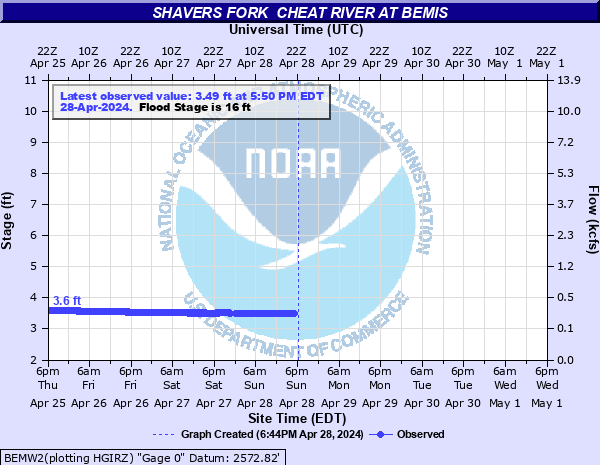
Shavers Fork Cheat River at Bemis
Critical Stages
13' - Action
16' - Flood
17' - Moderate
18' - Major
Latest Observation
Updated: 1:25 AM EST 12/18/25
Status: No Flooding
Stage: 3.47 ft
Flow: 0.234 kcfs
Forecast
Forecast not available for this location.
| Time | Stage (ft) | Flow (kcfs) |
|---|---|---|
| 1:40 AM 12/18 | 3.47 | 0.234 |
| 1:35 AM 12/18 | 3.47 | 0.234 |
| 1:30 AM 12/18 | 3.47 | 0.234 |
| 1:25 AM 12/18 | 3.47 | 0.234 |
| 1:20 AM 12/18 | 3.47 | 0.234 |
| 1:15 AM 12/18 | 3.47 | 0.234 |
| 1:10 AM 12/18 | 3.47 | 0.234 |
| 1:05 AM 12/18 | 3.47 | 0.234 |
| 1:00 AM 12/18 | 3.47 | 0.234 |
| 12:55 AM 12/18 | 3.47 | 0.234 |
| 12:50 AM 12/18 | 3.47 | 0.234 |
| 12:45 AM 12/18 | 3.47 | 0.234 |
| 12:40 AM 12/18 | 3.47 | 0.234 |
| 12:35 AM 12/18 | 3.48 | 0.238 |
| 12:30 AM 12/18 | 3.47 | 0.234 |
| 12:25 AM 12/18 | 3.48 | 0.238 |
| 12:20 AM 12/18 | 3.48 | 0.238 |
| 12:15 AM 12/18 | 3.48 | 0.238 |
| 12:10 AM 12/18 | 3.48 | 0.238 |
| 12:05 AM 12/18 | 3.48 | 0.238 |
| 12:00 AM 12/18 | 3.47 | 0.234 |
| 11:55 PM 12/17 | 3.48 | 0.238 |
| 11:50 PM 12/17 | 3.48 | 0.238 |
| 11:45 PM 12/17 | 3.48 | 0.238 |
| 11:40 PM 12/17 | 3.48 | 0.238 |
| 11:35 PM 12/17 | 3.48 | 0.238 |
| 11:30 PM 12/17 | 3.48 | 0.238 |
| 11:25 PM 12/17 | 3.48 | 0.238 |
| 11:20 PM 12/17 | 3.48 | 0.238 |
| 11:15 PM 12/17 | 3.48 | 0.238 |
18' -
Several homes and buildings in Bemis, both upstream and downstream from the bridge flood.
17' -
County Route 22 floods resulting in no access to Bemis from Glady.
16' -
County Route 22 bridge floods along with a few homes and camps near the river.
14' -
Water begins to surround or affect cabins and buildings near the river.
| Date | Stage (ft) |
|---|---|
| Jan 19, 1996 | 15 |
| Nov 5, 1985 | 14 |
| Mar 13, 1918 | 13.01 |
Data provided by the National Weather Service.