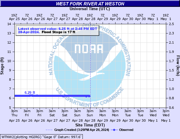
West Fork River at Weston
Critical Stages
15' - Action
17' - Flood
23' - Moderate
25' - Major
Latest Observation
Updated: 1:45 AM EST 12/5/25
Status: No Flooding
Stage: 6.22 ft
Flow: 0.828 kcfs
Forecast
Forecast not available for this location.
| Time | Stage (ft) | Flow (kcfs) |
|---|---|---|
| 1:45 AM 12/5 | 6.22 | 0.828 |
| 1:30 AM 12/5 | 6.22 | 0.828 |
| 1:15 AM 12/5 | 6.22 | 0.828 |
| 1:00 AM 12/5 | 6.22 | 0.828 |
| 12:45 AM 12/5 | 6.22 | 0.828 |
| 12:30 AM 12/5 | 6.22 | 0.828 |
| 12:15 AM 12/5 | 6.22 | 0.828 |
| 12:00 AM 12/5 | 6.22 | 0.828 |
| 11:45 PM 12/4 | 6.22 | 0.828 |
| 11:30 PM 12/4 | 6.22 | 0.828 |
| 11:15 PM 12/4 | 6.22 | 0.828 |
| 11:00 PM 12/4 | 6.22 | 0.828 |
| 10:45 PM 12/4 | 6.22 | 0.828 |
| 10:30 PM 12/4 | 6.22 | 0.828 |
| 10:15 PM 12/4 | 6.22 | 0.828 |
| 10:00 PM 12/4 | 6.22 | 0.828 |
| 9:45 PM 12/4 | 6.22 | 0.828 |
| 9:30 PM 12/4 | 6.23 | 0.831 |
| 9:15 PM 12/4 | 6.22 | 0.828 |
| 9:00 PM 12/4 | 6.22 | 0.828 |
| 8:45 PM 12/4 | 6.22 | 0.828 |
| 8:30 PM 12/4 | 6.23 | 0.831 |
| 8:15 PM 12/4 | 6.23 | 0.831 |
| 8:00 PM 12/4 | 6.23 | 0.831 |
| 7:45 PM 12/4 | 6.23 | 0.831 |
| 7:30 PM 12/4 | 6.23 | 0.831 |
| 7:15 PM 12/4 | 6.23 | 0.831 |
| 7:00 PM 12/4 | 6.22 | 0.828 |
| 6:45 PM 12/4 | 6.22 | 0.828 |
| 6:30 PM 12/4 | 6.23 | 0.831 |
30' -
Main Street and Route 19 400 feet from the river gage is flooded.
26.5' -
Tremendous property damage to the entire business district in Weston.
25' -
Water enters the Weston Police Department. The left bank side of the end of Second Street Bridge is flooded.
24.5' -
The park near the left bank end of Second Street highway bridge is flooded.
24' -
The foot of the First Street Bridge across West Fork about 0.1 miles upstream from the river gage, and the roadway 60 feet upstream from river gage, are flooded.
23' -
Basement flooding in numerous businesses on West Second Street and the west side of Main Street. Also, the junior high school begins to flood.
22' -
Homes along River Avenue, 300 feet downstream from the river gage, begin to be affected by high water. Some property damage.
21.7' -
Top of river bank flooded, 300 feet downstream from the river gage.
20.5' -
Top of river the bank is flooded, 100 feet upstream from the river gage (River Avenue).
20.1' -
Water is over River Avenue, about 200-400 feet downstream from the river gage. Some homes are also flooded.
20' -
Lower portions of the railroad bridge, 0.8 miles downstream from the river gage begin to flood.
17' -
The center line of River Avenue along the river, 300 feet downstream from the river gage begins to flood.
15' -
Water starts to overflow left bank onto River Avenue, from about 200 feet downstream to about 1 mile downstream from the river gage.
| Date | Stage (ft) |
|---|---|
| Jun 25, 1950 | 25.5 |
| Nov 5, 1985 | 24.1 |
| Oct 13, 1890 | 23 |
| Mar 7, 1967 | 22.5 |
| Apr 16, 1939 | 22.3 |
| Feb 10, 1957 | 22.3 |
| Mar 19, 1963 | 22.2 |
| Jan 26, 1978 | 21.9 |
| Jun 19, 1940 | 21.3 |
| Nov 19, 2003 | 20.79 |
| May 1, 1966 | 20.2 |
| Feb 14, 1948 | 20.1 |
| Oct 16, 1954 | 20 |
| Dec 16, 1948 | 20 |
| Jun 1, 1974 | 20 |
| Dec 14, 1956 | 20 |
| Dec 31, 1969 | 19.8 |
| Dec 9, 1978 | 19.75 |
| Oct 28, 1937 | 19.7 |
| May 11, 1933 | 19.6 |
Data provided by the National Weather Service.