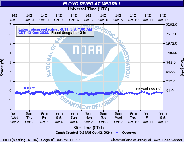
Floyd River at Merrill
Critical Stages
10' - Action
12' - Flood
14' - Moderate
16' - Major
Latest Observation
Updated: 1:00 PM CST 12/16/25
Status: No Flooding
Stage: 0.27 ft
Flow: 0.133 kcfs
Forecast
Forecast not available for this location.
| Time | Stage (ft) | Flow (kcfs) |
|---|---|---|
| 1:00 PM 12/16 | 0.27 | 0.133 |
| 11:00 AM 12/16 | 0.31 | 0.139 |
| 10:00 AM 12/16 | 0.36 | 0.146 |
| 9:00 AM 12/16 | 0.35 | 0.145 |
| 8:00 AM 12/16 | 0.45 | 0.16 |
| 7:00 AM 12/16 | 0.45 | 0.16 |
| 6:00 AM 12/16 | 0.4 | 0.152 |
| 5:00 AM 12/16 | 0.43 | 0.157 |
| 4:00 AM 12/16 | 0.43 | 0.157 |
| 3:00 AM 12/16 | 0.45 | 0.16 |
| 2:00 AM 12/16 | 0.45 | 0.16 |
| 1:00 AM 12/16 | 0.36 | 0.146 |
| 12:00 AM 12/16 | 0.35 | 0.145 |
| 11:00 PM 12/15 | 0.36 | 0.146 |
| 9:00 PM 12/15 | 0.36 | 0.146 |
| 8:00 PM 12/15 | 0.32 | 0.14 |
| 7:00 PM 12/15 | 0.36 | 0.146 |
| 6:00 PM 12/15 | 0.31 | 0.139 |
| 5:00 PM 12/15 | 0.2 | 0.122 |
| 4:00 PM 12/15 | 0.11 | 0.108 |
| 3:00 PM 12/15 | 0.03 | -999 |
| 2:00 PM 12/15 | -0.03 | -999 |
| 1:00 PM 12/15 | -0.01 | -999 |
| 12:00 PM 12/15 | 0.06 | -999 |
| 11:00 AM 12/15 | 0.02 | -999 |
| 10:00 AM 12/15 | 0.29 | 0.136 |
| 9:00 AM 12/15 | 0.41 | 0.154 |
| 8:00 AM 12/15 | 0.51 | 0.169 |
| 7:00 AM 12/15 | 0.5 | 0.167 |
| 6:00 AM 12/15 | 0.56 | 0.176 |
24' -
230th Street east of the bridge at the gage will be flooded. Water nears the feedhorn of the automated sensor and thus river level data may be lost.
23' -
Water reaches the bottom of the bridge at the gauging location on 230th Street.
22' -
Portions of Hwy 75 near Merrill begin to flood. The bridge on County Road C38 is overtopped. The highest banks and levees are overtopped.
20.5' -
The railroad tracks at the bridge 750 feet upstream of the gage are flooded.
19' -
Water reaches the bottom of the bridge on County Road C38. Approximately 2200 acres of farm land are flooded.
17.5' -
The levees protecting the sewage treatment lagoons on the left bank of the river are overtopped.
16' -
Flooding begins to affect the eastern edges of the city of Merrill, including some structures. The lowest portions of C44 also begin to flood. About 2000 acres of farm land are under water.
14' -
Approximately 1600 acres of farm land are flooded. The utility station off of C44 may flood if levee protection fails.
12' -
Flooding of the low lying farm land begins.
10' -
The lowest banks begin to be overtopped.
| Date | Stage (ft) |
|---|---|
| Jun 23, 2024 | 20.19 |
| Sep 18, 1926 | 20 |
| Jun 7, 1934 | 18.4 |
| Jun 8, 1953 | 18 |
| Mar 15, 2019 | 17.6 |
| Jun 16, 1983 | 17 |
| Sep 21, 2018 | 17 |
| Mar 24, 1979 | 17 |
| Jan 1, 1901 | 16.8 |
| Apr 5, 1969 | 16.6 |
| Apr 4, 1966 | 16.5 |
| Mar 29, 1962 | 16.03 |
| Mar 29, 1960 | 16 |
| Feb 19, 1971 | 15.98 |
| Jun 21, 1996 | 15.9 |
| Mar 5, 1937 | 15.6 |
| Jun 4, 1942 | 15.25 |
| Jun 9, 1932 | 15 |
| Mar 28, 1912 | 14.8 |
| Mar 30, 1952 | 14.8 |
Data provided by the National Weather Service.