« Back to Monroe Township Rivers
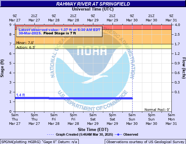
Rahway River at Springfield
Critical Stages
6.5' - Action
7' - Flood
8.5' - Moderate
10.5' - Major
Latest Observation
Updated: 9:30 AM EST 12/6/25
Status: No Flooding
Stage: 1.32 ft
Flow: 0.0171 kcfs
Forecast
Forecast not available for this location.
| Time | Stage (ft) | Flow (kcfs) |
|---|---|---|
| 9:30 AM 12/6 | 1.32 | 0.0171 |
| 9:15 AM 12/6 | 1.32 | 0.0171 |
| 9:00 AM 12/6 | 1.32 | 0.0171 |
| 8:45 AM 12/6 | 1.32 | 0.0171 |
| 8:30 AM 12/6 | 1.32 | 0.0171 |
| 8:15 AM 12/6 | 1.32 | 0.0171 |
| 8:00 AM 12/6 | 1.32 | 0.0171 |
| 7:45 AM 12/6 | 1.32 | 0.0171 |
| 7:30 AM 12/6 | 1.32 | 0.0171 |
| 7:15 AM 12/6 | 1.32 | 0.0171 |
| 7:00 AM 12/6 | 1.32 | 0.0171 |
| 6:45 AM 12/6 | 1.32 | 0.0171 |
| 6:30 AM 12/6 | 1.32 | 0.0171 |
| 6:15 AM 12/6 | 1.32 | 0.0171 |
| 6:00 AM 12/6 | 1.32 | 0.0171 |
| 5:45 AM 12/6 | 1.32 | 0.0171 |
| 5:30 AM 12/6 | 1.32 | 0.0171 |
| 5:15 AM 12/6 | 1.32 | 0.0171 |
| 5:00 AM 12/6 | 1.32 | 0.0171 |
| 4:45 AM 12/6 | 1.32 | 0.0171 |
| 4:30 AM 12/6 | 1.32 | 0.0171 |
| 4:15 AM 12/6 | 1.32 | 0.0171 |
| 4:00 AM 12/6 | 1.32 | 0.0171 |
| 3:45 AM 12/6 | 1.32 | 0.0171 |
| 3:30 AM 12/6 | 1.32 | 0.0171 |
| 3:15 AM 12/6 | 1.32 | 0.0171 |
| 3:00 AM 12/6 | 1.32 | 0.0171 |
| 2:45 AM 12/6 | 1.32 | 0.0171 |
| 2:30 AM 12/6 | 1.32 | 0.0171 |
| 2:15 AM 12/6 | 1.32 | 0.0171 |
10.5' -
Major flooding along Laurel Drive, Milltown Road and Smithfield Drive. Major flooding behind Petco's and Blink Fitness shopping center parking lot near Black Brook Park. Major flooding near Kenilworth Blvd between Dorset Drive and Wilshire Drive. Major flooding along Springfield Avenue, Central Avenue and Eastman Street. Moderate flooding along W Holly Street.
8.5' -
Moderate flooding along Laurel Drive, Milltown Road and Smithfield Drive. Moderate flooding behind Petco's and Blink Fitness shopping center parking lot near Black Brook Park. Moderate flooding near Kenilworth Blvd between Dorset Drive and Wilshire Drive. Moderate flooding along Springfield Avenue, Central Avenue and Eastman Street. Minor flood along W Holly Street.
7' -
Minor flooding along Laurel Drive, Milltown Road and Smithfield Drive. Minor flooding behind Petco's and Blink Fitness shopping center parking lot near Black Brook Park. Minor flooding near Kenilworth Blvd between Dorset Drive and Wilshire Drive.
| Date | Stage (ft) |
|---|---|
| Aug 28, 2011 | 10.88 |
| Sep 2, 2021 | 10.81 |
| Sep 16, 1999 | 10.67 |
| Aug 2, 1973 | 9.76 |
| Jul 25, 1997 | 9.56 |
| Oct 19, 1996 | 9.38 |
| Apr 15, 2007 | 9.35 |
| Jun 5, 1992 | 8.63 |
| May 29, 1968 | 8.5 |
| Jul 14, 1975 | 8.31 |
| Mar 13, 2010 | 8.08 |
| Jul 23, 1938 | 7.41 |
| Dec 21, 1973 | 7.2 |
| Mar 7, 2011 | 6.95 |
| Jan 4, 1982 | 6.92 |
| Jan 24, 1979 | 6.72 |
| Mar 11, 2011 | 6.61 |
| Mar 12, 1962 | 6.58 |
| Sep 19, 1945 | 6.2 |
| Nov 17, 1985 | 5.88 |
Data provided by the National Weather Service.