« Back to Monroe Township Rivers
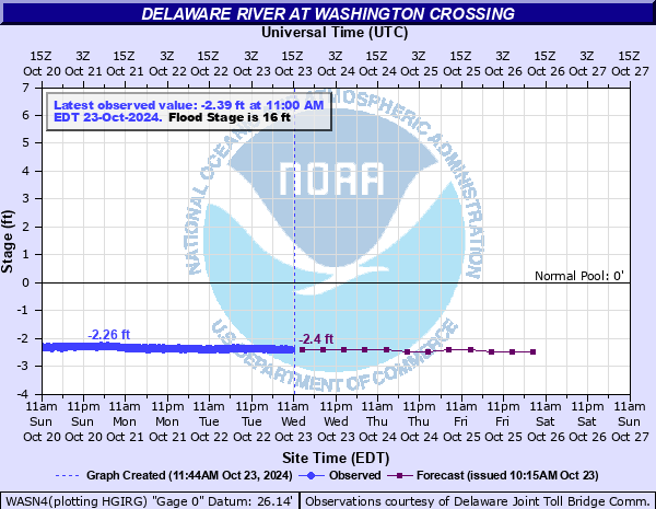
Delaware River at Washington Crossing
Critical Stages
12' - Action
16' - Flood
19' - Moderate
22' - Major
Latest Observation
Updated: 9:00 AM EST 12/6/25
Status: No Flooding
Stage: -2.34 ft
Flow: -999 kcfs
Forecast
| Time | Stage (ft) | Flow (kcfs) |
|---|---|---|
| 1 PM 12/6 | -2.3 | -999 |
| 7 PM 12/6 | -2.4 | -999 |
| 1 AM 12/7 | -2.4 | -999 |
| 7 AM 12/7 | -2.4 | -999 |
| 1 PM 12/7 | -2.4 | -999 |
| 7 PM 12/7 | -2.4 | -999 |
| 1 AM 12/8 | -2.4 | -999 |
| 7 AM 12/8 | -2.4 | -999 |
| Time | Stage (ft) | Flow (kcfs) |
|---|---|---|
| 9:00 AM 12/6 | -2.34 | -999 |
| 8:45 AM 12/6 | -2.36 | -999 |
| 8:30 AM 12/6 | -2.35 | -999 |
| 8:15 AM 12/6 | -2.34 | -999 |
| 8:00 AM 12/6 | -2.32 | -999 |
| 7:45 AM 12/6 | -2.33 | -999 |
| 7:30 AM 12/6 | -2.34 | -999 |
| 7:15 AM 12/6 | -2.32 | -999 |
| 7:00 AM 12/6 | -2.32 | -999 |
| 6:45 AM 12/6 | -2.34 | -999 |
| 6:30 AM 12/6 | -2.32 | -999 |
| 6:15 AM 12/6 | -2.33 | -999 |
| 6:00 AM 12/6 | -2.32 | -999 |
| 5:45 AM 12/6 | -2.33 | -999 |
| 5:30 AM 12/6 | -2.33 | -999 |
| 5:15 AM 12/6 | -2.31 | -999 |
| 5:00 AM 12/6 | -2.3 | -999 |
| 4:45 AM 12/6 | -2.32 | -999 |
| 4:30 AM 12/6 | -2.32 | -999 |
| 4:15 AM 12/6 | -2.33 | -999 |
| 4:00 AM 12/6 | -2.31 | -999 |
| 3:45 AM 12/6 | -2.31 | -999 |
| 3:30 AM 12/6 | -2.31 | -999 |
| 3:15 AM 12/6 | -2.3 | -999 |
| 3:00 AM 12/6 | -2.3 | -999 |
| 2:45 AM 12/6 | -2.3 | -999 |
| 2:30 AM 12/6 | -2.3 | -999 |
| 2:15 AM 12/6 | -2.31 | -999 |
| 2:00 AM 12/6 | -2.3 | -999 |
| 1:45 AM 12/6 | -2.3 | -999 |
22.5' -
Route 532 at the Canal bridge in Upper Makefield Township is impassable.
16.5' -
Flooding begins on Lower River Drive in Washington Crossing State Park. Flooding also occurs on Upper Drive near House #1 in the Titusville section of Hopewell Township.
16' -
River Road, between Mt. Eyre Road and Gilbert Street, in Upper Makefield Township begins to flood. First floor homes in the area take on water.
14' -
Intersection of River Road and overlook in Upper Makefield Township begins to flood.
12' -
Low points on the Pennsylvania Route 32 begin to flood.
11.5' -
The intersection of River Road and Jonathan Way just south of the canal in Upper Makefield Township begins to flood.
| Date | Stage (ft) |
|---|---|
| Aug 20, 1955 | 27.77 |
| Oct 11, 1903 | 25.9 |
| Apr 4, 2005 | 23.1 |
| Jun 29, 2006 | 22.54 |
| Mar 19, 1936 | 21.3 |
| Mar 13, 1936 | 20.21 |
| Sep 19, 2004 | 20.2 |
| Sep 8, 2011 | 20.04 |
| Jan 21, 1996 | 18.45 |
| Sep 2, 2021 | 16.91 |
| Jan 28, 1996 | 16.47 |
| Mar 12, 2011 | 16.41 |
| May 30, 1984 | 16.17 |
| Aug 29, 2011 | 16.06 |
| Jun 30, 1973 | 14.97 |
| Oct 17, 1955 | 14.89 |
Data provided by the National Weather Service.