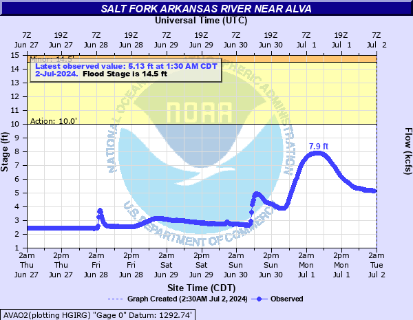
Salt Fork Arkansas River near Alva
Critical Stages
10' - Action
14.5' - Flood
16.5' - Moderate
18' - Major
Latest Observation
Updated: 3:30 AM CST 12/16/25
Status: No Flooding
Stage: 3 ft
Flow: 0.0827 kcfs
Forecast
Forecast not available for this location.
| Time | Stage (ft) | Flow (kcfs) |
|---|---|---|
| 3:30 AM 12/16 | 3 | 0.0827 |
| 3:15 AM 12/16 | 3 | 0.0827 |
| 3:00 AM 12/16 | 3 | 0.0827 |
| 2:45 AM 12/16 | 2.99 | 0.081 |
| 2:30 AM 12/16 | 3 | 0.0827 |
| 2:15 AM 12/16 | 3.01 | 0.0844 |
| 2:00 AM 12/16 | 3 | 0.0827 |
| 1:45 AM 12/16 | 3 | 0.0827 |
| 1:30 AM 12/16 | 3.01 | 0.0844 |
| 1:15 AM 12/16 | 3.01 | 0.0844 |
| 1:00 AM 12/16 | 3.01 | 0.0844 |
| 12:45 AM 12/16 | 3.01 | 0.0844 |
| 12:30 AM 12/16 | 3 | 0.0827 |
| 12:15 AM 12/16 | 3 | 0.0827 |
| 12:00 AM 12/16 | 3 | 0.0827 |
| 11:45 PM 12/15 | 3.01 | 0.0844 |
| 11:30 PM 12/15 | 3 | 0.0827 |
| 11:15 PM 12/15 | 3 | 0.0827 |
| 11:00 PM 12/15 | 3.01 | 0.0844 |
| 10:45 PM 12/15 | 3 | 0.0827 |
| 10:30 PM 12/15 | 3.01 | 0.0844 |
| 10:15 PM 12/15 | 3 | 0.0827 |
| 10:00 PM 12/15 | 3 | 0.0827 |
| 9:45 PM 12/15 | 3 | 0.0827 |
| 9:30 PM 12/15 | 3.01 | 0.0844 |
| 9:15 PM 12/15 | 3.01 | 0.0844 |
| 9:00 PM 12/15 | 3.01 | 0.0844 |
| 8:45 PM 12/15 | 3.01 | 0.0844 |
| 8:30 PM 12/15 | 3.02 | 0.0861 |
| 8:15 PM 12/15 | 3.02 | 0.0861 |
17' -
Flood waters damage farm property and block many low-lying roads along the river in northeastern Woods and northern Alfalfa counties.
16.5' -
Flood waters damage farm property and block many low-lying roads along the river in northeastern Woods and northern Alfalfa counties.
15.5' -
Flood waters inundate farm property and block many low-lying roads along the river in northeastern Woods and northern Alfalfa counties.
14.5' -
Floodwaters inundate farm property and block many low-lying roads along the river in northeastern Woods and northern Alfalfa counties.
14' -
Flooding of lowlands to depths up to 3 feet occurs along the river in parts of northeastern Woods and northern Alfalfa counties.
13' -
Flooding of lowlands to depths up to 2 feet occurs along the river in parts of northeastern Woods and northern Alfalfa counties.
12' -
Shallow flooding of lowlands to depths up to 1 foot occurs along the river in parts of northeastern Woods and northern Alfalfa counties.
11' -
Bankfull levels occur along the river in parts of northeastern Woods and northern Alfalfa counties.
10' -
Near bankfull levels occur along the river in parts of northeastern Woods and northern Alfalfa counties.
| Date | Stage (ft) |
|---|---|
| May 26, 2019 | 15.49 |
| Oct 10, 1985 | 15.24 |
| Oct 30, 1979 | 15.04 |
| Mar 24, 1987 | 14.91 |
| Nov 1, 1999 | 14.83 |
| May 26, 2000 | 14.7 |
| Oct 9, 2018 | 14.53 |
| Jul 7, 1904 | 14.5 |
| May 16, 1949 | 14.43 |
| Mar 24, 2000 | 14.42 |
| May 8, 2019 | 14.32 |
| Oct 23, 1941 | 14.08 |
| Jun 12, 1989 | 14.07 |
| Apr 11, 1997 | 13.89 |
| May 1, 1985 | 13.74 |
| Sep 28, 1945 | 13.65 |
| Jul 10, 1982 | 13.62 |
| Jun 30, 1951 | 13.52 |
| May 23, 1938 | 13.42 |
| Jun 28, 1948 | 13.26 |
Data provided by the National Weather Service.