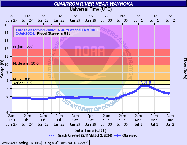
Cimarron River near Waynoka
Critical Stages
7.5' - Action
8' - Flood
10' - Moderate
12' - Major
Latest Observation
Updated: 3:30 AM CST 12/16/25
Status: No Flooding
Stage: 6.04 ft
Flow: 0.105 kcfs
Forecast
Forecast not available for this location.
| Time | Stage (ft) | Flow (kcfs) |
|---|---|---|
| 3:30 AM 12/16 | 6.04 | 0.105 |
| 3:00 AM 12/16 | 6.07 | 0.115 |
| 2:30 AM 12/16 | 6.04 | 0.105 |
| 2:00 AM 12/16 | 6.04 | 0.105 |
| 1:30 AM 12/16 | 6.04 | 0.105 |
| 1:00 AM 12/16 | 6.04 | 0.105 |
| 12:30 AM 12/16 | 6.04 | 0.105 |
| 12:00 AM 12/16 | 6.04 | 0.105 |
| 11:30 PM 12/15 | 6.04 | 0.105 |
| 11:00 PM 12/15 | 6.05 | 0.108 |
| 10:30 PM 12/15 | 6.05 | 0.108 |
| 10:00 PM 12/15 | 6.05 | 0.108 |
| 9:30 PM 12/15 | 6.05 | 0.108 |
| 9:00 PM 12/15 | 6.05 | 0.108 |
| 8:30 PM 12/15 | 6.04 | 0.105 |
| 8:00 PM 12/15 | 6.04 | 0.105 |
| 7:30 PM 12/15 | 6.01 | 0.0946 |
| 7:00 PM 12/15 | 6.13 | 0.137 |
| 6:30 PM 12/15 | 6.11 | 0.129 |
| 6:00 PM 12/15 | 6.1 | 0.125 |
| 5:30 PM 12/15 | 6.1 | 0.125 |
| 5:00 PM 12/15 | 6.06 | 0.111 |
| 4:30 PM 12/15 | 6.07 | 0.115 |
| 4:00 PM 12/15 | 6.07 | 0.115 |
| 3:30 PM 12/15 | 6.07 | 0.115 |
| 3:00 PM 12/15 | 6.06 | 0.111 |
| 2:30 PM 12/15 | 6.02 | 0.0982 |
| 2:00 PM 12/15 | 6.05 | 0.108 |
| 1:30 PM 12/15 | 6.04 | 0.105 |
| 1:00 PM 12/15 | 6.04 | 0.105 |
16' -
Expect flooding of agricultural lands... gas wells... and rural roads. Some fields may be isolated by deep flows in cutoff channels meandering across the flood plain. The river reach affected extends from near Freedom upstream... to the U.S. Highway 281 crossing south of Little Sahara State Park near Waynoka... to near Orienta in Major County.
15' -
Expect flooding of agricultural lands... gas wells... and rural roads. Some fields may be isolated by deep flows in cutoff channels meandering across the flood plain. The river reach affected extends from near Freedom upstream... to the U.S. Highway 281 crossing south of Little Sahara State Park near Waynoka... to near Orienta in Major County.
14' -
Expect flooding of agricultural lands... gas wells... and rural roads. Some fields may be isolated by deep flows in cutoff channels meandering across the flood plain. The river reach affected extends from near Freedom upstream... to the U.S. Highway 281 crossing south of Little Sahara State Park near Waynoka... to near Orienta in Major County.
13' -
Expect flooding of agricultural lands... gas wells... and rural roads. Some fields may be isolated by deep flows in cutoff channels meandering across the flood plain. The river reach affected extends from near Freedom upstream... to the U.S. Highway 281 crossing south of Little Sahara State Park near Waynoka... to near Orienta in Major County.
12' -
Expect flooding of agricultural lands... gas wells... and rural roads. Some fields may be isolated by deep flows in cutoff channels meandering across the flood plain. The river reach affected extends from near Freedom upstream... to the U.S. Highway 281 crossing south of Little Sahara State Park near Waynoka... to near Orienta in Major County.
11' -
Expect flooding of agricultural lands... gas wells... and rural roads. Some fields may be isolated by deep flows in cutoff channels meandering across the flood plain. The river reach affected extends from near Freedom upstream... to the U.S. Highway 281 crossing south of Little Sahara State Park near Waynoka... to near Orienta in Major County.
10' -
Expect flooding of agricultural lands... gas wells... and rural roads. Some fields may be isolated by deep flows in cutoff channels meandering across the flood plain. The river reach affected extends from near Freedom upstream... to the U.S. Highway 281 crossing south of Little Sahara State Park near Waynoka... to near Orienta in Major County.
9' -
Expect shallow flooding of agricultural lands along the river. Some fields may be isolated by deep flows in cutoff channels meandering across the flood plain. The river reach affected extends from near Freedom upstream... to the U.S. Highway 281 crossing south of Little Sahara State Park near Waynoka... to near Orienta in Major County.
8' -
Bankfull conditions exist along the river... and some overflows may occur over some low-lying areas near the river. The river reach affected extends from near Freedom upstream... to the U.S. Highway 281 crossing south of Little Sahara State Park near Waynoka... to near Orienta in Major County.
7' -
Near bankfull conditions exist along the river... and some overflows may occur over some low-lying areas near the river. The river reach affected extends from near Freedom upstream... to the U.S. Highway 281 crossing south of Little Sahara State Park near Waynoka... to near Orienta in Major County.
6' -
The river remains within its banks from near Freedom upstream... to the U.S. Highway 281 crossing south of Little Sahara State Park near Waynoka... to near Orienta in Major County.
| Date | Stage (ft) |
|---|---|
| May 16, 1957 | 15.1 |
| May 19, 1935 | 14.5 |
| Jun 23, 1957 | 11.78 |
| May 10, 1979 | 11.7 |
| Jul 28, 1950 | 11.4 |
| May 26, 2019 | 11.32 |
| Oct 9, 2018 | 11.12 |
| Jun 12, 2005 | 10.75 |
| May 26, 2000 | 10.74 |
| May 23, 1938 | 10.7 |
| Jun 17, 2005 | 10.63 |
| May 30, 1957 | 10.56 |
| Apr 22, 1942 | 10.5 |
| May 27, 2019 | 10.49 |
| Nov 1, 1998 | 10.41 |
| Jun 9, 1995 | 10.19 |
| Jul 1, 1999 | 10.13 |
| May 9, 2019 | 10.12 |
| May 21, 2019 | 10.1 |
| Sep 2, 1974 | 10.08 |
Data provided by the National Weather Service.