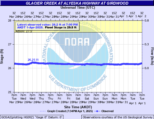
Glacier Creek at Alyeska Highway at Girdwood
Critical Stages
27.5' - Action
29.5' - Flood
31' - Moderate
32' - Major
Latest Observation
Updated: 10:00 AM AKST 12/9/25
Status: No Flooding
Stage: 26.05 ft
Flow: 0.0466 kcfs
Forecast
Forecast not available for this location.
| Time | Stage (ft) | Flow (kcfs) |
|---|---|---|
| 10:00 AM 12/9 | 26.05 | 0.0466 |
| 9:45 AM 12/9 | 26.05 | 0.0466 |
| 9:30 AM 12/9 | 26.05 | 0.0466 |
| 9:15 AM 12/9 | 26.05 | 0.0466 |
| 9:00 AM 12/9 | 26.06 | 0.0478 |
| 8:45 AM 12/9 | 26.05 | 0.0466 |
| 8:30 AM 12/9 | 26.05 | 0.0466 |
| 8:15 AM 12/9 | 26.06 | 0.0478 |
| 8:00 AM 12/9 | 26.06 | 0.0478 |
| 7:45 AM 12/9 | 26.05 | 0.0466 |
| 7:30 AM 12/9 | 26.06 | 0.0478 |
| 7:15 AM 12/9 | 26.05 | 0.0466 |
| 7:00 AM 12/9 | 26.05 | 0.0466 |
| 6:45 AM 12/9 | 26.06 | 0.0478 |
| 6:30 AM 12/9 | 26.06 | 0.0478 |
| 6:15 AM 12/9 | 26.06 | 0.0478 |
| 6:00 AM 12/9 | 26.06 | 0.0478 |
| 5:45 AM 12/9 | 26.05 | 0.0466 |
| 5:30 AM 12/9 | 26.06 | 0.0478 |
| 5:15 AM 12/9 | 26.06 | 0.0478 |
| 5:00 AM 12/9 | 26.07 | 0.0491 |
| 4:45 AM 12/9 | 26.06 | 0.0478 |
| 4:30 AM 12/9 | 26.07 | 0.0491 |
| 4:15 AM 12/9 | 26.07 | 0.0491 |
| 4:00 AM 12/9 | 26.07 | 0.0491 |
| 3:45 AM 12/9 | 26.07 | 0.0491 |
| 3:30 AM 12/9 | 26.08 | 0.0504 |
| 3:15 AM 12/9 | 26.07 | 0.0491 |
| 3:00 AM 12/9 | 26.07 | 0.0491 |
| 2:45 AM 12/9 | 26.07 | 0.0491 |
29' -
Tahoe Road will start to flood at this level. Houses on the south side of Tahoe Road will have water at thier foundations at a stage of around 30 ft.
27.5' -
This is the lowest spot on the LHB (south bank) near Tahoe Road.No structures would be threatened at this level.
| Date | Stage (ft) |
|---|---|
| Sep 22, 2012 | 28.96 |
| Dec 9, 2019 | 28.54 |
| May 11, 2018 | 28.28 |
| Oct 13, 2013 | 28.01 |
| Oct 2, 2010 | 27.96 |
| Oct 16, 2018 | 27.9 |
| Oct 3, 2003 | 27.8 |
| Sep 5, 2017 | 27.78 |
| Aug 25, 2006 | 27.63 |
| Sep 22, 2016 | 27.54 |
| Jun 22, 2008 | 27.45 |
| Sep 9, 2005 | 27.35 |
| Jun 2, 2010 | 27.13 |
| Sep 29, 2015 | 27.03 |
| Jun 17, 2004 | 26.79 |
| Jun 23, 2007 | 26.79 |
| Sep 27, 2013 | 26.75 |
| Jul 29, 2009 | 26.49 |
Data provided by the National Weather Service.