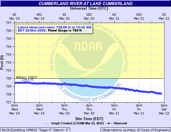
Cumberland River at Lake Cumberland
Critical Stages
730' - Action
760' - Flood
760' - Moderate
760' - Major
Latest Observation
Updated: 4:45 AM EST 12/16/25
Status: No Flooding
Stage: 688.19 ft
Flow: -999 kcfs
Forecast
Forecast not available for this location.
| Time | Stage (ft) | Flow (kcfs) |
|---|---|---|
| 4:45 AM 12/16 | 688.19 | -999 |
| 4:30 AM 12/16 | 688.21 | -999 |
| 4:15 AM 12/16 | 688.19 | -999 |
| 4:00 AM 12/16 | 688.21 | -999 |
| 3:45 AM 12/16 | 688.2 | -999 |
| 3:30 AM 12/16 | 688.21 | -999 |
| 3:15 AM 12/16 | 688.21 | -999 |
| 3:00 AM 12/16 | 688.21 | -999 |
| 2:45 AM 12/16 | 688.21 | -999 |
| 2:30 AM 12/16 | 688.21 | -999 |
| 2:15 AM 12/16 | 688.21 | -999 |
| 2:00 AM 12/16 | 688.2 | -999 |
| 1:45 AM 12/16 | 688.13 | -999 |
| 1:30 AM 12/16 | 688.2 | -999 |
| 1:15 AM 12/16 | 688.17 | -999 |
| 1:00 AM 12/16 | 688.16 | -999 |
| 12:45 AM 12/16 | 688.15 | -999 |
| 12:30 AM 12/16 | 688.2 | -999 |
| 12:15 AM 12/16 | 688.18 | -999 |
| 12:00 AM 12/16 | 688.17 | -999 |
| 11:45 PM 12/15 | 688.14 | -999 |
| 11:30 PM 12/15 | 688.12 | -999 |
| 11:15 PM 12/15 | 688.17 | -999 |
| 11:00 PM 12/15 | 688.2 | -999 |
| 10:45 PM 12/15 | 688.2 | -999 |
| 10:30 PM 12/15 | 688.2 | -999 |
| 10:15 PM 12/15 | 688.21 | -999 |
| 10:00 PM 12/15 | 688.22 | -999 |
| 9:45 PM 12/15 | 688.22 | -999 |
| 9:30 PM 12/15 | 688.23 | -999 |
760' -
Top of flood control pool.
740' -
Top of power pool, spillway crest elevation.
723' -
Summer pool.
690' -
Winter pool.
673' -
Bottom of power pool.
| Date | Stage (ft) |
|---|---|
| Feb 26, 2019 | 756.52 |
| May 13, 1984 | 751.69 |
| Mar 1, 1994 | 751.42 |
Data provided by the National Weather Service.