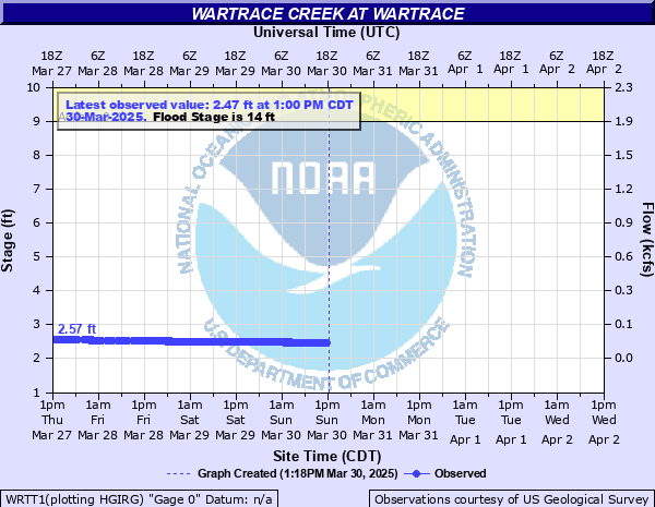
Wartrace Creek at Wartrace
Critical Stages
9' - Action
14' - Flood
17' - Moderate
20' - Major
Latest Observation
Updated: 11:00 AM CST 12/7/25
Status: No Flooding
Stage: 2.68 ft
Flow: 0.0504 kcfs
Forecast
Forecast not available for this location.
| Time | Stage (ft) | Flow (kcfs) |
|---|---|---|
| 11:00 AM 12/7 | 2.68 | 0.0504 |
| 10:45 AM 12/7 | 2.68 | 0.0504 |
| 10:30 AM 12/7 | 2.68 | 0.0504 |
| 10:15 AM 12/7 | 2.68 | 0.0504 |
| 10:00 AM 12/7 | 2.68 | 0.0504 |
| 9:45 AM 12/7 | 2.68 | 0.0504 |
| 9:30 AM 12/7 | 2.68 | 0.0504 |
| 9:15 AM 12/7 | 2.68 | 0.0504 |
| 9:00 AM 12/7 | 2.68 | 0.0504 |
| 8:45 AM 12/7 | 2.68 | 0.0504 |
| 8:30 AM 12/7 | 2.69 | 0.0517 |
| 8:15 AM 12/7 | 2.69 | 0.0517 |
| 8:00 AM 12/7 | 2.69 | 0.0517 |
| 7:45 AM 12/7 | 2.69 | 0.0517 |
| 7:30 AM 12/7 | 2.69 | 0.0517 |
| 7:15 AM 12/7 | 2.69 | 0.0517 |
| 7:00 AM 12/7 | 2.69 | 0.0517 |
| 6:45 AM 12/7 | 2.69 | 0.0517 |
| 6:30 AM 12/7 | 2.69 | 0.0517 |
| 6:15 AM 12/7 | 2.69 | 0.0517 |
| 6:00 AM 12/7 | 2.7 | 0.053 |
| 5:45 AM 12/7 | 2.7 | 0.053 |
| 5:30 AM 12/7 | 2.7 | 0.053 |
| 5:15 AM 12/7 | 2.7 | 0.053 |
| 5:00 AM 12/7 | 2.7 | 0.053 |
| 4:45 AM 12/7 | 2.7 | 0.053 |
| 4:30 AM 12/7 | 2.7 | 0.053 |
| 4:15 AM 12/7 | 2.7 | 0.053 |
| 4:00 AM 12/7 | 2.7 | 0.053 |
| 3:45 AM 12/7 | 2.7 | 0.053 |
24' -
Significant flooding along Wartrace Creek is impacting homes and properties on Jernigan Ln and Main St West, and is flooding many roads in the area including Bridge St, Jernigan Ln, Higgins Rd south of Hwy 269, Canon Rd east of Hwy 64, Fairfield Pike east of the railroad crossing, Hwy 269 west of Wartrace, and Hwy 64 south of Wartrace. Flooding is also impacting properties on Hwy 64 near Canon Rd, and the electrical substation just south of the creek.
22' -
Significant flooding continues to impact homes and properties on Jernigan Ln and Main St West. Bridge St, Jernigan Ln, Higgins Rd south of Hwy 269, Canon Rd east of Hwy 64, Fairfield Pike east of the railroad crossing, and water approaches Hwy 269 west of Wartrace are flooded and impassable. Water covers railroad tracks north of Wartrace, and approaches properties on Hwy 64 near Canon Rd, as well as Hwy 64 south of Wartrace, and the electrical substation just south of the creek.
21' -
Water approaches railroad tracks north of Wartrace.
20' -
Significant flooding is occurring along the creek, impacting homes and properties on Jernigan Ln and Main St West. Bridge St, Jernigan Ln, Higgins Rd south of Hwy 269, Canon Rd east of Hwy 64, and Fairfield Pike east of the railroad crossing are flooded and impassable, and water approaches Hwy 269 west of Wartrace.
19' -
Widespread flooding continues along the creek, impacting homes and properties on Jernigan Ln and Main St West. Bridge St and Jernigan Ln are impassable, as well as Higgins Rd south of Hwy 269 and Canon Rd east of Hwy 64. Water approaches Fairfield Pike east of the railroad crossing, and may be impassable at higher levels.
17' -
Widespread flooding is occurring along the creek, and is impacting homes and properties on Jernigan Ln and Main St West. Bridge St and Jernigan Ln are impassable, as well as Higgins Rd south of Hwy 269, and water approaches Canon Rd east of Hwy 64.
16' -
Flooding continues to impact areas along the creek. Bridge St is flooded between Hwy 269 and Jernigan Ln, and water approaches homes at the end of Jernigan Ln and on Main St West. Access to Jernigan Ln may be limited at higher water levels. Higgins Rd south of Hwy 269 is impassable, and most of Winette Ayers Park is inundated.
14' -
Flooding along the creek is impacting most of Winette Ayers Park, and Bridge St between Hwy 269 and Jernigan Ln, and Higgins Rd south of Hwy 269 are covered with water and may be impassable. Water also approaches properties on Jernigan Ln.
13' -
Areas along the creek, including agricultural land and Winette Ayers Park are significantly inundated, and water approaches Bridge St between Hwy 269 and Jernigan Ln, and Higgins Rd south of Hwy 269.
11' -
Water continues to inundate low-lying areas along the creek, including agricultural land and Winette Ayers Park.
9' -
Water begins to inundate low-lying areas along the creek including Winette Ayers Park.
| Date | Stage (ft) |
|---|---|
| May 6, 2003 | 16.72 |
| Jan 23, 1999 | 16.02 |
| Jan 23, 2002 | 15.15 |
| Sep 22, 1992 | 15.12 |
| Jan 23, 2006 | 13.94 |
| Dec 4, 1994 | 13.55 |
| May 2, 2009 | 13.3 |
| Apr 3, 2000 | 13.24 |
| Jan 7, 1998 | 13.17 |
| Dec 21, 1990 | 13 |
| Nov 30, 1996 | 12.93 |
| May 3, 2010 | 12.52 |
| Feb 5, 2004 | 12.39 |
| Apr 27, 2011 | 11.94 |
| Jul 9, 2014 | 11.9 |
| Jul 9, 2016 | 11.9 |
| Feb 16, 2001 | 11.79 |
| Jul 5, 2013 | 11.57 |
| Apr 22, 2017 | 11.51 |
| Oct 14, 2014 | 11.49 |
Data provided by the National Weather Service.