« Back to Mountain View Rivers
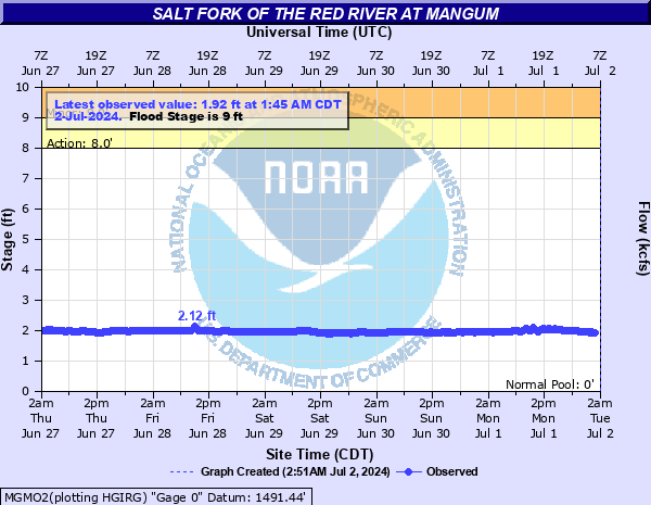
Salt Fork of the Red River at Mangum
Critical Stages
8' - Action
9' - Flood
11' - Moderate
13' - Major
Latest Observation
Updated: 9:45 PM CST 12/14/25
Status: No Flooding
Stage: 3.43 ft
Flow: 0.0156 kcfs
Forecast
Forecast not available for this location.
| Time | Stage (ft) | Flow (kcfs) |
|---|---|---|
| 10:45 PM 12/14 | 3.42 | 0.0149 |
| 10:30 PM 12/14 | 3.41 | 0.0141 |
| 10:15 PM 12/14 | 3.42 | 0.0149 |
| 10:00 PM 12/14 | 3.43 | 0.0156 |
| 9:45 PM 12/14 | 3.43 | 0.0156 |
| 9:30 PM 12/14 | 3.42 | 0.0149 |
| 9:15 PM 12/14 | 3.42 | 0.0149 |
| 9:00 PM 12/14 | 3.42 | 0.0149 |
| 8:45 PM 12/14 | 3.42 | 0.0149 |
| 8:30 PM 12/14 | 3.43 | 0.0156 |
| 8:15 PM 12/14 | 3.42 | 0.0149 |
| 8:00 PM 12/14 | 3.42 | 0.0149 |
| 7:45 PM 12/14 | 3.42 | 0.0149 |
| 7:30 PM 12/14 | 3.42 | 0.0149 |
| 7:15 PM 12/14 | 3.42 | 0.0149 |
| 7:00 PM 12/14 | 3.42 | 0.0149 |
| 6:45 PM 12/14 | 3.42 | 0.0149 |
| 6:30 PM 12/14 | 3.42 | 0.0149 |
| 6:15 PM 12/14 | 3.42 | 0.0149 |
| 6:00 PM 12/14 | 3.42 | 0.0149 |
| 5:45 PM 12/14 | 3.42 | 0.0149 |
| 5:30 PM 12/14 | 3.42 | 0.0149 |
| 5:15 PM 12/14 | 3.43 | 0.0156 |
| 5:00 PM 12/14 | 3.42 | 0.0149 |
| 4:45 PM 12/14 | 3.42 | 0.0149 |
| 4:30 PM 12/14 | 3.42 | 0.0149 |
| 4:15 PM 12/14 | 3.42 | 0.0149 |
| 4:00 PM 12/14 | 3.42 | 0.0149 |
| 3:45 PM 12/14 | 3.42 | 0.0149 |
| 3:30 PM 12/14 | 3.42 | 0.0149 |
15' -
Expect valley-wide flooding of agricultural lands and rural roads in Harmon... Greer... and Jackson counties. No towns are affected. Flooding begins in Harmon County several hours before the crest passes the State Highway 34 crossing south of Mangum.
14' -
Expect valley-wide flooding of agricultural lands and rural roads in Harmon... Greer... and Jackson counties. No towns are affected. Flooding begins in Harmon County several hours before the crest passes the State Highway 34 crossing south of Mangum.
13' -
Expect widespread flooding of agricultural lands and rural roads in Harmon... Greer... and Jackson counties. No towns or major highways are affected. Flooding begins in Harmon County several hours before the crest passes the State Highway 34 crossing south of Mangum.
12' -
Expect widespread flooding of agricultural lands and rural roads in Harmon... Greer... and Jackson counties. No towns or major highways are affected. Flooding begins in Harmon County several hours before the crest passes the State Highway 34 crossing south of Mangum.
11' -
Expect flooding of agricultural lands and rural roads in Harmon... Greer... and Jackson counties. No towns or major highways are affected.
10' -
Expect flooding of agricultural and isolation of other low-lying areas in Harmon... Greer... and Jackson counties.
9' -
Expect flooding of agricultural bottomlands and isolation of other low-lying areas in Harmon... Greer... and Jackson counties.
8' -
Expect near bankfull stages along the river in Harmon... Greer... and Jackson counties.
| Date | Stage (ft) |
|---|---|
| Jun 16, 1938 | 14.7 |
| Oct 3, 1986 | 14.66 |
| May 16, 1957 | 14.55 |
| Apr 4, 1997 | 14.29 |
| Jul 19, 1953 | 13.75 |
| Jul 7, 1993 | 13.6 |
| May 27, 1977 | 13.5 |
| May 28, 1978 | 13.45 |
| Jun 10, 1954 | 13.3 |
| Apr 20, 1977 | 13.25 |
| Apr 24, 1973 | 13.17 |
| Jun 24, 1975 | 13.1 |
| Jun 4, 1995 | 12.88 |
| May 29, 1980 | 12.82 |
| Aug 3, 1995 | 12.72 |
| May 21, 1977 | 12.65 |
| Jun 4, 1965 | 12.38 |
| May 27, 1956 | 12.2 |
| Jun 8, 1941 | 12.2 |
| May 13, 1958 | 12.18 |
Data provided by the National Weather Service.