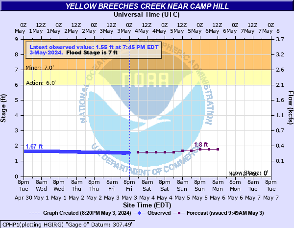
Yellow Breeches Creek near Camp Hill
Critical Stages
6' - Action
7' - Flood
9' - Moderate
13' - Major
Latest Observation
Updated: 8:45 AM EST 12/6/25
Status: No Flooding
Stage: 1.19 ft
Flow: 0.164 kcfs
Forecast
| Time | Stage (ft) | Flow (kcfs) |
|---|---|---|
| 1 PM 12/6 | 1.2 | 0.166 |
| 7 PM 12/6 | 1.2 | 0.166 |
| 1 AM 12/7 | 1.2 | 0.166 |
| 7 AM 12/7 | 1.2 | 0.166 |
| 1 PM 12/7 | 1.2 | 0.166 |
| 7 PM 12/7 | 1.2 | 0.166 |
| 1 AM 12/8 | 1.2 | 0.166 |
| 7 AM 12/8 | 1.2 | 0.166 |
| Time | Stage (ft) | Flow (kcfs) |
|---|---|---|
| 8:45 AM 12/6 | 1.19 | 0.164 |
| 8:30 AM 12/6 | 1.19 | 0.164 |
| 8:15 AM 12/6 | 1.19 | 0.164 |
| 8:00 AM 12/6 | 1.19 | 0.164 |
| 7:45 AM 12/6 | 1.19 | 0.164 |
| 7:30 AM 12/6 | 1.19 | 0.164 |
| 7:15 AM 12/6 | 1.19 | 0.164 |
| 7:00 AM 12/6 | 1.19 | 0.164 |
| 6:45 AM 12/6 | 1.19 | 0.164 |
| 6:30 AM 12/6 | 1.19 | 0.164 |
| 6:15 AM 12/6 | 1.19 | 0.164 |
| 6:00 AM 12/6 | 1.19 | 0.164 |
| 5:45 AM 12/6 | 1.19 | 0.164 |
| 5:30 AM 12/6 | 1.19 | 0.164 |
| 5:15 AM 12/6 | 1.19 | 0.164 |
| 5:00 AM 12/6 | 1.19 | 0.164 |
| 4:45 AM 12/6 | 1.19 | 0.164 |
| 4:30 AM 12/6 | 1.19 | 0.164 |
| 4:15 AM 12/6 | 1.19 | 0.164 |
| 4:00 AM 12/6 | 1.2 | 0.166 |
| 3:45 AM 12/6 | 1.19 | 0.164 |
| 3:30 AM 12/6 | 1.2 | 0.166 |
| 3:17 AM 12/6 | 1.2 | 0.166 |
| 3:15 AM 12/6 | 1.2 | 0.166 |
| 3:00 AM 12/6 | 1.2 | 0.166 |
| 2:45 AM 12/6 | 1.2 | 0.166 |
| 2:30 AM 12/6 | 1.2 | 0.166 |
| 2:15 AM 12/6 | 1.2 | 0.166 |
| 2:00 AM 12/6 | 1.2 | 0.166 |
| 1:45 AM 12/6 | 1.2 | 0.166 |
23.5' -
FEMA 0.2 0X0P+0nnual Chance Flood Level (500-year flood).
19' -
Many homes and businesses in the Yellow Breeches Creek basin are affected by flood waters.
18.8' -
Flood of record from September, 1975.
18' -
FEMA 1.0 0X0P+0nnual Chance Flood Level (100-year flood).
17' -
Many homes and businesses in the Yellow Breeches Creek basin are affected by flood waters. The flow of Yellow Breeches Creek is no longer confined to the single span bridge opening on Green Lane Drive near the gage. Both bridge approaches are inundated.
16' -
FEMA 2 0X0P+0nnual Chance Flood Level (50-year flood).
15' -
Numerous homes and businesses along Yellow Breeches Creek are affected by flood waters.
14' -
Flood waters begin to reach the Spanglers Mill Road Bridge.
13' -
Numerous homes along the entire length of Yellow Breeches Creek are affected by high water levels.
12' -
FEMA 10 0X0P+0nnual Chance Flood Level (10-year flood).
11' -
A number of homes along the entire length of Yellow Breeches Creek are affected by high water.
10.5' -
Flood waters begin to reach the Green Lane Drive Bridge.
10' -
Flood waters begin to reach the Slate Hill Road Bridge.
9' -
A number of homes in the Green Lane Farms development are affected by high water. Cedar Cliff Drive on the left bank upstream from the single span bridge on Green Lane Drive is inundated. Creekwood Drive has several feet of water on it, and water is approaching homes.
7' -
Low lying areas in the Green Lane Farms development on the right bank of Yellow Breeches Creek begin to flood. A mobile home park near Williams Grove is also affected by high water.
| Date | Stage (ft) |
|---|---|
| Sep 26, 1975 | 18.77 |
| Jun 22, 1972 | 18.33 |
| Apr 17, 2011 | 14.57 |
| Oct 9, 1976 | 11.66 |
| Jan 25, 1979 | 11.3 |
| Feb 15, 1984 | 10.78 |
| Sep 2, 2021 | 10.54 |
| Aug 10, 2024 | 10.45 |
| Jan 20, 1996 | 10.439999580383 |
| Jun 21, 2015 | 10.3 |
| Mar 12, 2011 | 10.11 |
| Jun 28, 2006 | 9.7 |
| Sep 8, 2011 | 9.6 |
| Jul 22, 1953 | 9.4 |
| Feb 26, 1979 | 9.28 |
| Apr 2, 1993 | 9.21 |
| Dec 14, 1983 | 9.08 |
| Sep 7, 2011 | 9.01 |
| Jul 10, 1970 | 8.9 |
| Oct 30, 2012 | 8.86 |
Data provided by the National Weather Service.