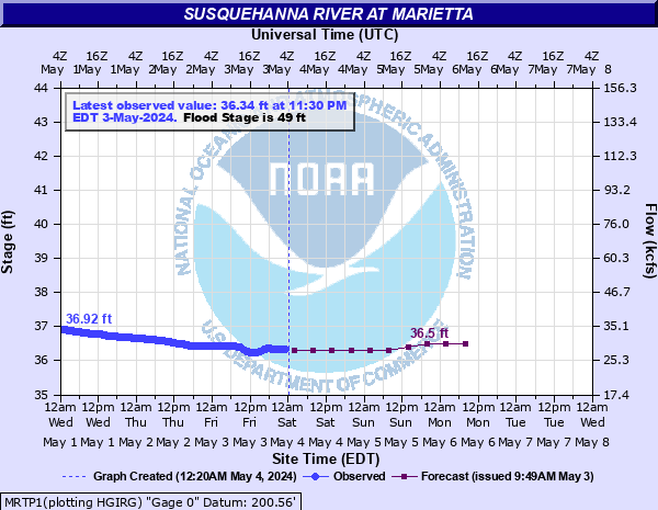
Susquehanna River at Marietta
Critical Stages
44' - Action
49' - Flood
52' - Moderate
54' - Major
Latest Observation
Updated: 8:30 AM EST 12/6/25
Status: No Flooding
Stage: 34.54 ft
Flow: 14.3 kcfs
Forecast
| Time | Stage (ft) | Flow (kcfs) |
|---|---|---|
| 1 PM 12/6 | 34.5 | 14.1 |
| 7 PM 12/6 | 34.4 | 13.5 |
| 1 AM 12/7 | 34.4 | 13.5 |
| 7 AM 12/7 | 34.4 | 13.5 |
| 1 PM 12/7 | 34.4 | 13.5 |
| 7 PM 12/7 | 34.3 | 12.9 |
| 1 AM 12/8 | 34.3 | 12.9 |
| 7 AM 12/8 | 34.3 | 12.9 |
| Time | Stage (ft) | Flow (kcfs) |
|---|---|---|
| 9:30 AM 12/6 | 34.54 | 14.3 |
| 9:00 AM 12/6 | 34.54 | 14.3 |
| 8:30 AM 12/6 | 34.54 | 14.3 |
| 8:00 AM 12/6 | 34.54 | 14.3 |
| 7:30 AM 12/6 | 34.55 | 14.4 |
| 7:00 AM 12/6 | 34.55 | 14.4 |
| 6:30 AM 12/6 | 34.55 | 14.4 |
| 6:00 AM 12/6 | 34.55 | 14.4 |
| 5:30 AM 12/6 | 34.55 | 14.4 |
| 5:00 AM 12/6 | 34.55 | 14.4 |
| 4:30 AM 12/6 | 34.56 | 14.5 |
| 4:00 AM 12/6 | 34.56 | 14.5 |
| 3:30 AM 12/6 | 34.56 | 14.5 |
| 3:00 AM 12/6 | 34.56 | 14.5 |
| 2:30 AM 12/6 | 34.57 | 14.5 |
| 2:00 AM 12/6 | 34.57 | 14.5 |
| 1:30 AM 12/6 | 34.57 | 14.5 |
| 1:00 AM 12/6 | 34.57 | 14.5 |
| 12:30 AM 12/6 | 34.57 | 14.5 |
| 12:00 AM 12/6 | 34.57 | 14.5 |
| 11:30 PM 12/5 | 34.58 | 14.6 |
| 11:00 PM 12/5 | 34.58 | 14.6 |
| 10:30 PM 12/5 | 34.58 | 14.6 |
| 10:00 PM 12/5 | 34.58 | 14.6 |
| 9:30 PM 12/5 | 34.58 | 14.6 |
| 9:00 PM 12/5 | 34.59 | 14.7 |
| 8:30 PM 12/5 | 34.59 | 14.7 |
| 8:00 PM 12/5 | 34.59 | 14.7 |
| 7:30 PM 12/5 | 34.59 | 14.7 |
| 7:00 PM 12/5 | 34.59 | 14.7 |
64' -
Widespread flooding on both banks affects homes, businesses, and the water and sewage plants.
59' -
Widespread flooding occurs on both sides of the river. Many homes and businesses are affected by high water. The Wrightsville water supply is affected by flood waters.
56' -
Widespread flooding occurs on both sides of the river. Many homes and businesses are affected.
54' -
Numerous homes and businesses in the Columbia and Wrightsville areas are affected by high water. The Wilton Company in Wrightsville experiences problems with high water.
52' -
A number of residences in the Wrightsville and Columbia areas begin to be affected.
49' -
Front Street in Wrightsville floods. Low lying areas of route 624 on the right, or west bank and along route 441 on the left, or east bank are also affected. Riverside recreation area is also inundated.
47' -
Low lying undeveloped areas on both banks are inundated. A couple of roadways are closed.
44' -
The right, or west bank overflows. Some roadways are affected.
| Date | Stage (ft) |
|---|---|
| Jun 23, 1972 | 64.54 |
| Mar 19, 1936 | 60.73 |
| Jun 2, 1889 | 58.3 |
| Sep 9, 2011 | 58.16 |
| Jan 21, 1996 | 56.8 |
| Sep 19, 2004 | 56.27 |
| Sep 27, 1975 | 55.73 |
| May 29, 1946 | 54.9 |
| Mar 12, 1964 | 54.03 |
| Feb 16, 1984 | 53.49 |
| Apr 2, 1940 | 53.33 |
| Apr 3, 1993 | 53.22 |
| Mar 7, 1979 | 53.21 |
| Jan 1, 1943 | 53.2 |
| Nov 27, 1950 | 52.96 |
| Mar 12, 2011 | 52.86 |
| Jun 29, 2006 | 52.53 |
| Feb 27, 1961 | 51.82 |
| Apr 4, 2005 | 51.71 |
| Mar 16, 1986 | 51.52 |
Data provided by the National Weather Service.