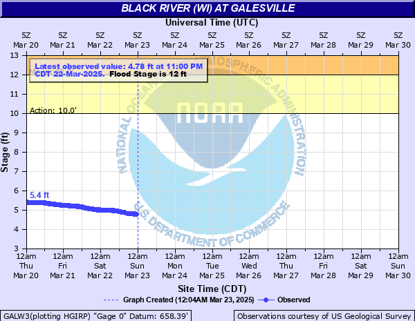
Black River (WI) at Galesville
Critical Stages
10' - Action
12' - Flood
13' - Moderate
15' - Major
Latest Observation
Updated: 4:00 AM CST 12/16/25
Status: No Flooding
Stage: 4.6 ft
Flow: 1.37 kcfs
Forecast
Forecast not available for this location.
| Time | Stage (ft) | Flow (kcfs) |
|---|---|---|
| 4:00 AM 12/16 | 4.6 | 1.37 |
| 3:45 AM 12/16 | 4.6 | 1.37 |
| 3:30 AM 12/16 | 4.6 | 1.37 |
| 3:15 AM 12/16 | 4.6 | 1.37 |
| 3:00 AM 12/16 | 4.6 | 1.37 |
| 2:45 AM 12/16 | 4.6 | 1.37 |
| 2:30 AM 12/16 | 4.6 | 1.37 |
| 2:15 AM 12/16 | 4.6 | 1.37 |
| 2:00 AM 12/16 | 4.6 | 1.37 |
| 1:45 AM 12/16 | 4.6 | 1.37 |
| 1:30 AM 12/16 | 4.59 | 1.36 |
| 1:15 AM 12/16 | 4.59 | 1.36 |
| 1:00 AM 12/16 | 4.6 | 1.37 |
| 12:45 AM 12/16 | 4.6 | 1.37 |
| 12:30 AM 12/16 | 4.6 | 1.37 |
| 12:15 AM 12/16 | 4.6 | 1.37 |
| 12:00 AM 12/16 | 4.59 | 1.36 |
| 11:45 PM 12/15 | 4.59 | 1.36 |
| 11:30 PM 12/15 | 4.59 | 1.36 |
| 11:15 PM 12/15 | 4.59 | 1.36 |
| 11:00 PM 12/15 | 4.59 | 1.36 |
| 10:45 PM 12/15 | 4.59 | 1.36 |
| 10:30 PM 12/15 | 4.59 | 1.36 |
| 10:15 PM 12/15 | 4.59 | 1.36 |
| 10:00 PM 12/15 | 4.59 | 1.36 |
| 9:45 PM 12/15 | 4.59 | 1.36 |
| 9:30 PM 12/15 | 4.59 | 1.36 |
| 9:15 PM 12/15 | 4.58 | 1.35 |
| 9:00 PM 12/15 | 4.58 | 1.35 |
| 8:45 PM 12/15 | 4.58 | 1.35 |
12' -
Flooding mainly impacts wildlands and agricultural pasture land. The approaches on both ends of the County Road VV bridge over the Black River in Jackson County may begin to flood and the bridge gates may be closed.
10' -
The recreational area and boat landing off Highway 35 begins to flood.
| Date | Stage (ft) |
|---|---|
| Sep 25, 2010 | 16.79 |
| Jun 21, 1993 | 16.64 |
| Sep 23, 1980 | 15.46 |
| Sep 24, 1986 | 15.14 |
| Oct 27, 2023 | 14.98 |
| Sep 24, 2016 | 14.96 |
| Apr 20, 2019 | 14.95 |
| Mar 8, 1983 | 14.84 |
| Aug 29, 2021 | 14.81 |
| Jun 29, 1998 | 14.76 |
| Apr 1, 1967 | 14.63 |
| Mar 25, 1979 | 14.54 |
| Apr 22, 2023 | 14.52 |
| Mar 13, 1973 | 14.51 |
| Jun 8, 1980 | 14.36 |
| Sep 11, 1938 | 14.31 |
| Sep 18, 1992 | 14.09 |
| Apr 3, 1952 | 14 |
| Apr 14, 2001 | 13.97 |
| Apr 5, 1982 | 13.93 |
Data provided by the National Weather Service.