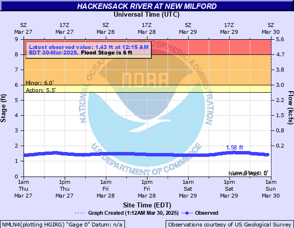
Hackensack River at New Milford
Critical Stages
5.5' - Action
6' - Flood
8' - Moderate
10' - Major
Latest Observation
Updated: 12:15 PM EST 12/7/25
Status: No Flooding
Stage: 1.51 ft
Flow: 0.0089 kcfs
Forecast
Forecast not available for this location.
| Time | Stage (ft) | Flow (kcfs) |
|---|---|---|
| 12:15 PM 12/7 | 1.51 | 0.0089 |
| 12:00 PM 12/7 | 1.5 | 0.008 |
| 11:45 AM 12/7 | 1.5 | 0.008 |
| 11:30 AM 12/7 | 1.49 | 0.007 |
| 11:15 AM 12/7 | 1.49 | 0.007 |
| 11:00 AM 12/7 | 1.48 | 0.0061 |
| 10:45 AM 12/7 | 1.47 | 0.0053 |
| 10:30 AM 12/7 | 1.46 | 0.0047 |
| 10:15 AM 12/7 | 1.44 | 0.0035 |
| 10:00 AM 12/7 | 1.43 | 0.0031 |
| 9:45 AM 12/7 | 1.43 | 0.0031 |
| 9:30 AM 12/7 | 1.43 | 0.0031 |
| 9:15 AM 12/7 | 1.43 | 0.0031 |
| 9:00 AM 12/7 | 1.44 | 0.0035 |
| 8:45 AM 12/7 | 1.44 | 0.0035 |
| 8:30 AM 12/7 | 1.44 | 0.0035 |
| 8:15 AM 12/7 | 1.44 | 0.0035 |
| 8:00 AM 12/7 | 1.44 | 0.0035 |
| 7:45 AM 12/7 | 1.44 | 0.0035 |
| 7:30 AM 12/7 | 1.45 | 0.004 |
| 7:15 AM 12/7 | 1.45 | 0.004 |
| 7:00 AM 12/7 | 1.45 | 0.004 |
| 6:45 AM 12/7 | 1.45 | 0.004 |
| 6:30 AM 12/7 | 1.45 | 0.004 |
| 6:15 AM 12/7 | 1.45 | 0.004 |
| 6:00 AM 12/7 | 1.45 | 0.004 |
| 5:45 AM 12/7 | 1.45 | 0.004 |
| 5:30 AM 12/7 | 1.45 | 0.004 |
| 5:15 AM 12/7 | 1.45 | 0.004 |
| 5:00 AM 12/7 | 1.45 | 0.004 |
10' -
Home evacuations due to water into homes along Columbia Street, Harvard Street, Pine Avenue and Lenox Avenue. River Edge Road to River Road closed due to flooding. New Milford Avenue closed due to flooding.
8' -
Water into homes along Columbia Street, Harvard Street, Pine Avenue and Lenox Avenue. Flooding along River Edge Road to River Road. Flooding along New Milford Avenue.
6' -
Minor flooding along Columbia Street, Harvard Street, Pine Avenue and Lenox Avenue. Water up to River Edge Road to River Road and New Milford Avenue.
| Date | Stage (ft) |
|---|---|
| Apr 16, 2007 | 12.36 |
| Sep 16, 1999 | 11.45 |
| May 17, 1989 | 8.23 |
| Apr 5, 1984 | 7.96 |
| Nov 9, 1977 | 7.95 |
| Mar 14, 2010 | 7.68 |
| Mar 7, 2011 | 7.35 |
| Apr 5, 1987 | 6.76 |
| Mar 11, 2011 | 6.33 |
| May 17, 1990 | 6.01 |
Data provided by the National Weather Service.