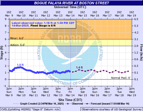
Bogue Falaya River at Boston Street
Critical Stages
5' - Action
6' - Flood
11' - Moderate
17' - Major
Latest Observation
Updated: 12:30 PM CST 12/15/25
Status: No Flooding
Stage: 0.97 ft
Flow: 0.0988 kcfs
Forecast
| Time | Stage (ft) | Flow (kcfs) |
|---|---|---|
| 6 PM 12/15 | 0.6 | 0.081 |
| 12 AM 12/16 | 0.7 | 0.086 |
| 6 AM 12/16 | 1.1 | 0.115 |
| 12 PM 12/16 | 0.9 | 0.096 |
| 6 PM 12/16 | 0.6 | 0.081 |
| 12 AM 12/17 | 1 | 0.1 |
| 6 AM 12/17 | 1.2 | 0.13 |
| 12 PM 12/17 | 1 | 0.1 |
| 6 PM 12/17 | 0.6 | 0.081 |
| 12 AM 12/18 | 1 | 0.1 |
| 6 AM 12/18 | 1.2 | 0.13 |
| 12 PM 12/18 | 1 | 0.1 |
| 6 PM 12/18 | 0.6 | 0.081 |
| 12 AM 12/19 | 1 | 0.1 |
| 6 AM 12/19 | 1.3 | 0.146 |
| 12 PM 12/19 | 1 | 0.1 |
| 6 PM 12/19 | 0.8 | 0.091 |
| 12 AM 12/20 | 1.1 | 0.115 |
| 6 AM 12/20 | 1.3 | 0.146 |
| Time | Stage (ft) | Flow (kcfs) |
|---|---|---|
| 1:30 PM 12/15 | 0.97 | 0.0988 |
| 1:15 PM 12/15 | 0.99 | 0.0996 |
| 1:00 PM 12/15 | 0.98 | 0.0992 |
| 12:45 PM 12/15 | 0.96 | 0.0984 |
| 12:30 PM 12/15 | 0.97 | 0.0988 |
| 12:15 PM 12/15 | 0.98 | 0.0992 |
| 12:00 PM 12/15 | 0.99 | 0.0996 |
| 11:45 AM 12/15 | 1.02 | 0.103 |
| 11:30 AM 12/15 | 1.05 | 0.107 |
| 11:15 AM 12/15 | 1.07 | 0.11 |
| 11:00 AM 12/15 | 1.06 | 0.109 |
| 10:45 AM 12/15 | 1.02 | 0.103 |
| 10:30 AM 12/15 | 0.98 | 0.0992 |
| 10:15 AM 12/15 | 0.97 | 0.0988 |
| 10:00 AM 12/15 | 0.94 | 0.0976 |
| 9:45 AM 12/15 | 0.91 | 0.0964 |
| 9:30 AM 12/15 | 0.89 | 0.0955 |
| 9:15 AM 12/15 | 0.88 | 0.095 |
| 9:00 AM 12/15 | 0.91 | 0.0964 |
| 8:45 AM 12/15 | 0.95 | 0.098 |
| 8:30 AM 12/15 | 0.98 | 0.0992 |
| 8:15 AM 12/15 | 1.04 | 0.106 |
| 8:00 AM 12/15 | 1.06 | 0.109 |
| 7:45 AM 12/15 | 1.04 | 0.106 |
| 7:30 AM 12/15 | 0.98 | 0.0992 |
| 7:15 AM 12/15 | 0.97 | 0.0988 |
| 7:00 AM 12/15 | 0.96 | 0.0984 |
| 6:45 AM 12/15 | 0.94 | 0.0976 |
| 6:30 AM 12/15 | 0.91 | 0.0964 |
| 6:15 AM 12/15 | 0.88 | 0.095 |
20' -
Flood of Record occurred on March 12, 2016. Widespread flooding will develop in downtown Covington and below the gauge. Businesses will be inaccessible along parts of U.S. Hwy. 190 and along Military Rd. The bridge at U.S. Hwy 190 will be inundated. Bogue Falaya Park and homes along the river will be flooded.
17' -
Water will back up on the Abita River flooding most of the area between U.S. Hwy 190 and LA Hwy 36. The river will be at the undercarriage of the East Boston Street bridge.
15' -
Water on East Boston Street and on LA Hwy 21 east of the river will make driving hazardous. Low-lying areas near the Bogue Falaya and Abita Rivers will flood.
13.5' -
Homes along River Bend Road will flood. Water will be in the ground floor classrooms of Christ Episcopal School.
12' -
River Bend Road will be under water threatening adjacent homes. Bogue Falaya River Park and Christ Episcopal School grounds will remain flooded.
11' -
There will be more widespread flooding around the grounds of the Christ Episcopal School and Bogue Falaya River Park.
9' -
Bogue Falaya River Park will become inundated.
7' -
Water will rise onto the west bank flooding property of the Bogue Falaya Towers at East Boston Street and threatening commercial property on the east bank near Military Road. Bogue Falaya River Park and Christ Episcopal School grounds will begin to flood.
6' -
The river will leave its banks under the Boston Street Bridge and begin to flood the Bogue Falaya Towers property.
| Date | Stage (ft) |
|---|---|
| Mar 12, 2016 | 19.2 |
| Jan 21, 1993 | 17.1 |
| Jul 1, 2003 | 16.63 |
| Feb 22, 1961 | 16.5 |
| Jun 11, 2001 | 15.91 |
| Aug 30, 2021 | 15.49 |
| Aug 30, 2012 | 15.39 |
| Jan 7, 1998 | 14.2 |
| Oct 4, 2002 | 14 |
| Mar 8, 1998 | 13.98 |
| Sep 26, 2002 | 13.83 |
| Feb 24, 2016 | 13.2 |
| Sep 12, 2024 | 13.07 |
| Sep 2, 2008 | 13.03 |
| Apr 15, 2021 | 12.73 |
| May 15, 2020 | 12.51 |
| Apr 3, 1988 | 12.4 |
| Dec 28, 2018 | 11.9 |
| Jan 25, 2024 | 11.86 |
| Aug 30, 2005 | 11.83 |
Data provided by the National Weather Service.