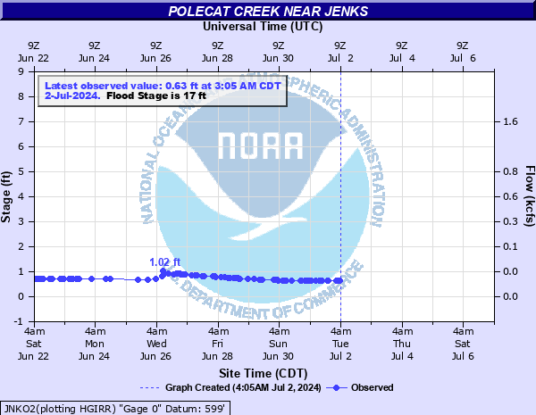
Polecat Creek near Jenks
Critical Stages
17' - Action
17' - Flood
19' - Moderate
21' - Major
Latest Observation
Updated: 6:09 PM LMT 12/31/00
Status: Obs Not Current
Stage: -999 ft
Flow: -999 kcfs
Forecast
Forecast not available for this location.
| Time | Stage (ft) | Flow (kcfs) |
|---|---|---|
| 2:05 PM 11/16 | 0.84 | 0.0067 |
| 12:05 PM 11/16 | 0.84 | 0.0067 |
| 4:05 PM 11/15 | 0.82 | 0.0057 |
| 2:05 PM 11/15 | 0.83 | 0.0062 |
| 1:05 PM 11/15 | 0.83 | 0.0062 |
| 12:05 PM 11/15 | 0.83 | 0.0062 |
| 12:05 PM 11/14 | 0.81 | 0.0053 |
| 12:05 PM 11/13 | 0.8 | 0.0049 |
| 5:05 PM 11/12 | 0.83 | 0.0062 |
| 3:05 PM 11/12 | 0.83 | 0.0062 |
| 1:05 PM 11/12 | 0.83 | 0.0062 |
| 12:05 PM 11/12 | 0.83 | 0.0062 |
| 11:05 PM 11/11 | 0.83 | 0.0062 |
| 10:05 PM 11/11 | 0.83 | 0.0062 |
| 8:05 PM 11/11 | 0.83 | 0.0062 |
| 5:05 PM 11/11 | 0.82 | 0.0057 |
| 4:05 PM 11/11 | 0.83 | 0.0062 |
| 3:05 PM 11/11 | 0.83 | 0.0062 |
| 2:00 PM 11/11 | 0.82 | 0.0057 |
| 12:05 PM 11/11 | 0.82 | 0.0057 |
| 6:05 AM 11/11 | 0.82 | 0.0057 |
| 4:05 AM 11/11 | 0.83 | 0.0062 |
| 3:05 AM 11/11 | 0.83 | 0.0062 |
| 1:05 AM 11/11 | 0.83 | 0.0062 |
| 12:05 AM 11/11 | 0.83 | 0.0062 |
| 11:05 PM 11/10 | 0.83 | 0.0062 |
| 7:05 PM 11/10 | 0.83 | 0.0062 |
| 5:05 PM 11/10 | 0.82 | 0.0057 |
| 1:05 PM 11/10 | 0.82 | 0.0057 |
| 12:05 PM 11/10 | 0.82 | 0.0057 |
27' -
widespread and disastrous flooding occurs. Untied mobile homes in the park south of the Jenks levee may float. Many suburban homes near the Creek County line are flooded to a depth of several feet. This is an extremely dangerous and life threatening situation.
25' -
widespread and severe flooding occurs west and south of the Jenks levee. The mobile home park south of the Jenks levee is flooded. Suburban homes near the Creek County line are flooded. This is an extremely dangerous and life threatening situation.
23' -
widespread and severe flooding occurs west of Jenks. The mobile home park south of the Jenks levee begins to flood at 23 feet. Suburban homes near the Creek County line may be flooded. This is an extremely dangerous and life threatening situation.
21' -
severe flooding occurs along Polecat Creek in suburban areas west of Jenks. South Elwood Street becomes unsafe as the stage reaches 21 feet. Some rural roads are inundated. This is higher than the May 1998 flood when the river reached 20.5 feet and will approach the 21.8 foot crest from the October 1986 flood. This is a dangerous situation.
19' -
moderate agricultural flooding occurs. Minor flooding occurs in suburban areas along Polecat Creek west of Jenks.
17' -
minor agricultural flooding occurs, primarily west of Jenks.
| Date | Stage (ft) |
|---|---|
| Jun 8, 1974 | 25 |
| Oct 2, 1986 | 21.8 |
| May 7, 2000 | 20.35 |
| May 9, 1995 | 20.2 |
| Apr 26, 1999 | 20.1 |
| Oct 5, 1998 | 19.2 |
| Jun 10, 1979 | 18.53 |
| May 22, 2019 | 18 |
| Apr 28, 1998 | 17.9 |
| May 27, 1995 | 17.65 |
| Mar 17, 1998 | 17.2 |
| May 21, 2019 | 17.02 |
| May 3, 1990 | 17 |
| May 6, 2022 | 16.91 |
| Jun 7, 1978 | 16.55 |
| Dec 28, 2015 | 16.53 |
| May 29, 2019 | 16.41 |
| May 13, 1982 | 15.67 |
| Oct 20, 1983 | 15.22 |
| Jun 19, 2015 | 14 |
Data provided by the National Weather Service.