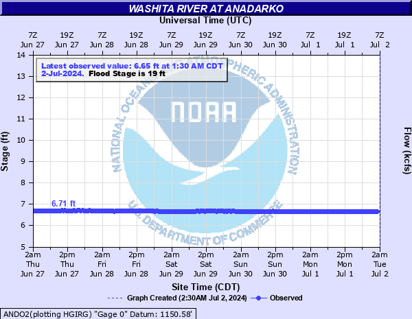
Washita River at Anadarko
Critical Stages
17' - Action
19' - Flood
21' - Moderate
23' - Major
Latest Observation
Updated: 8:30 PM CST 12/10/25
Status: No Flooding
Stage: 6.92 ft
Flow: 0.125 kcfs
Forecast
Forecast not available for this location.
| Time | Stage (ft) | Flow (kcfs) |
|---|---|---|
| 8:30 PM 12/10 | 6.92 | 0.125 |
| 8:00 PM 12/10 | 6.92 | 0.125 |
| 7:30 PM 12/10 | 6.93 | 0.129 |
| 7:00 PM 12/10 | 6.92 | 0.125 |
| 6:30 PM 12/10 | 6.92 | 0.125 |
| 6:00 PM 12/10 | 6.93 | 0.129 |
| 5:30 PM 12/10 | 6.93 | 0.129 |
| 5:00 PM 12/10 | 6.92 | 0.125 |
| 4:30 PM 12/10 | 6.92 | 0.125 |
| 4:00 PM 12/10 | 6.93 | 0.129 |
| 3:30 PM 12/10 | 6.93 | 0.129 |
| 3:00 PM 12/10 | 6.93 | 0.129 |
| 2:30 PM 12/10 | 6.93 | 0.129 |
| 2:00 PM 12/10 | 6.93 | 0.129 |
| 1:30 PM 12/10 | 6.93 | 0.129 |
| 1:00 PM 12/10 | 6.93 | 0.129 |
| 12:30 PM 12/10 | 6.93 | 0.129 |
| 12:00 PM 12/10 | 6.92 | 0.125 |
| 11:30 AM 12/10 | 6.92 | 0.125 |
| 11:00 AM 12/10 | 6.91 | 0.121 |
| 10:30 AM 12/10 | 6.91 | 0.121 |
| 10:00 AM 12/10 | 6.91 | 0.121 |
| 9:30 AM 12/10 | 6.92 | 0.125 |
| 9:00 AM 12/10 | 6.91 | 0.121 |
| 8:30 AM 12/10 | 6.92 | 0.125 |
| 8:00 AM 12/10 | 6.9 | 0.117 |
| 7:30 AM 12/10 | 6.91 | 0.121 |
| 7:00 AM 12/10 | 6.92 | 0.125 |
| 6:30 AM 12/10 | 6.9 | 0.117 |
| 6:00 AM 12/10 | 6.91 | 0.121 |
28' -
Areas in and near the Randlett Park are flooded. Farm levees are overtopped... and property severely damaged. Rural roads in Caddo and western Grady counties are closed. Minor flooding could occur in the town of Verden.
27' -
Areas in and near the Randlett Park are flooded. Farm levees are overtopped... and property severely damaged. Rural roads in Caddo and western Grady counties are closed. Minor flooding could occur in the town of Verden.
26' -
Areas in and near the Randlett Park are flooded. Farm levees are overtopped... and property severely damaged. Rural roads in Caddo and western Grady counties are closed.
25' -
Areas near the Randlett Park are flooded. Floodwaters breach farm levees... destroy farm property... and block many rural roads in Caddo and western Grady counties.
24' -
Campgrounds in the Randlett Park and nearby low areas are flooded. Floodwaters damage farm property and block many rural roads along the Washita River in eastern Caddo and western Grady counties... and could breach farm levees.
23' -
Campgrounds in the Randlett Park and nearby low areas are flooded. Floodwaters damage farm property and block many rural roads along the Washita River in eastern Caddo and western Grady counties... and could breach farm levees.
22' -
Campgrounds in the Randlett Park and nearby low areas are flooded. Floodwaters damage farm property and block many rural roads along the Washita River in eastern Caddo and western Grady counties... and could breach farm levees.
21' -
Floodwaters damage farm property... block many rural roads... and breach farm levees along the Washita River in eastern Caddo and western Grady counties.
20' -
Minor flooding may damage farm property and block rural roads along the Washita River in eastern Caddo and western Grady counties. Low-lying fields may become isolated by flooding of tributary streams.
19' -
Minor flooding may damage farm property and block rural roads along the Washita River in eastern Caddo and western Grady counties. Low-lying fields may become isolated by flooding of tributary streams.
18' -
Expect near bankfull conditions along the Washita River in eastern Caddo and western Grady counties. Low-lying fields may become isolated by overflows from tributary streams.
17' -
Expect near bankfull conditions along the Washita River in eastern Caddo and western Grady counties. Low-lying fields may become isolated by overflows from tributary streams.
| Date | Stage (ft) |
|---|---|
| Aug 20, 2007 | 26.02 |
| May 29, 1987 | 25.54 |
| Jun 6, 1995 | 25.37 |
| Oct 21, 1983 | 25.2 |
| May 11, 1993 | 25.03 |
| May 30, 1987 | 24.73 |
| May 28, 2019 | 24.42 |
| Sep 23, 1965 | 24.2 |
| May 26, 2015 | 23.9 |
| Oct 9, 1907 | 22.9 |
| Jun 30, 2007 | 22.26 |
| May 12, 2019 | 22.06 |
| Jul 2, 2007 | 22.01 |
| Oct 12, 2018 | 21.96 |
| Oct 22, 1965 | 21.8 |
| Jun 16, 1989 | 21.78 |
| May 22, 2015 | 21.77 |
| Jun 8, 1936 | 21.69 |
| Apr 25, 2019 | 21.66 |
| May 31, 1977 | 21.55 |
Data provided by the National Weather Service.