Little Washita River near Ninnekah
Critical Stages
15' - Action
20' - Flood
22' - Moderate
24' - Major
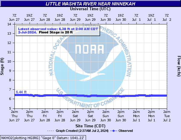
Latest Observation
Updated: 8:00 PM CST 12/10/25
Status: No Flooding
Stage: 6.5 ft
Flow: 0.0251 kcfs
Forecast
Forecast not available for this location.
| Time | Stage (ft) | Flow (kcfs) |
|---|---|---|
| 8:00 PM 12/10 | 6.5 | 0.0251 |
| 7:45 PM 12/10 | 6.5 | 0.0251 |
| 7:30 PM 12/10 | 6.5 | 0.0251 |
| 7:15 PM 12/10 | 6.5 | 0.0251 |
| 7:00 PM 12/10 | 6.5 | 0.0251 |
| 6:45 PM 12/10 | 6.5 | 0.0251 |
| 6:30 PM 12/10 | 6.5 | 0.0251 |
| 6:15 PM 12/10 | 6.5 | 0.0251 |
| 6:00 PM 12/10 | 6.5 | 0.0251 |
| 5:45 PM 12/10 | 6.5 | 0.0251 |
| 5:30 PM 12/10 | 6.49 | 0.0243 |
| 5:15 PM 12/10 | 6.49 | 0.0243 |
| 5:00 PM 12/10 | 6.49 | 0.0243 |
| 4:45 PM 12/10 | 6.49 | 0.0243 |
| 4:30 PM 12/10 | 6.48 | 0.0236 |
| 4:15 PM 12/10 | 6.49 | 0.0243 |
| 4:00 PM 12/10 | 6.48 | 0.0236 |
| 3:45 PM 12/10 | 6.49 | 0.0243 |
| 3:30 PM 12/10 | 6.48 | 0.0236 |
| 3:15 PM 12/10 | 6.48 | 0.0236 |
| 3:00 PM 12/10 | 6.48 | 0.0236 |
| 2:45 PM 12/10 | 6.48 | 0.0236 |
| 2:30 PM 12/10 | 6.49 | 0.0243 |
| 2:15 PM 12/10 | 6.49 | 0.0243 |
| 2:00 PM 12/10 | 6.49 | 0.0243 |
| 1:45 PM 12/10 | 6.49 | 0.0243 |
| 1:30 PM 12/10 | 6.48 | 0.0236 |
| 1:15 PM 12/10 | 6.49 | 0.0243 |
| 1:00 PM 12/10 | 6.49 | 0.0243 |
| 12:45 PM 12/10 | 6.48 | 0.0236 |
22' -
Agricultural lands and local roads along the river in Grady County may be inundated to depths of 2 feet.
21' -
Agricultural lands and local roads along the river in Grady County may be inundated to depths of 1 foot.
20' -
Agricultural lands and local roads along the river in Grady County may be inundated to shallow depths for a few hours.
19' -
Near bankfull levels occur along the river in Grady County.
| Date | Stage (ft) |
|---|---|
| May 24, 2015 | 25.2 |
| Jun 12, 2016 | 22.85 |
| Aug 19, 2007 | 21.73 |
| May 9, 1993 | 20.7 |
| Apr 10, 2008 | 20.65 |
| May 10, 1997 | 19.4 |
| May 30, 1997 | 19.4 |
| Dec 26, 2018 | 18.41 |
| May 5, 2022 | 17.85 |
| Apr 18, 2013 | 17.16 |
| Jul 9, 1994 | 16.5 |
| Mar 29, 2017 | 16.33 |
| Jan 4, 1998 | 16.32 |
| Apr 30, 2025 | 15.25 |
Data provided by the National Weather Service.