« Back to Northern Lights Rivers
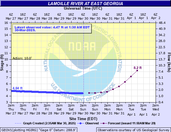
Lamoille River at East Georgia
Critical Stages
10' - Action
Flood
Moderate
Major
Latest Observation
Updated: 3:30 AM EST 12/15/25
Status: No Flooding
Stage: 4.95 ft
Flow: 1.9 kcfs
Forecast
| Time | Stage (ft) | Flow (kcfs) |
|---|---|---|
| 7 AM 12/15 | 3.4 | 0.573 |
| 1 PM 12/15 | 3.4 | 0.573 |
| 7 PM 12/15 | 3.4 | 0.573 |
| 1 AM 12/16 | 3.4 | 0.573 |
| 7 AM 12/16 | 3.4 | 0.573 |
| 1 PM 12/16 | 3.4 | 0.573 |
| 7 PM 12/16 | 3.3 | 0.52 |
| 1 AM 12/17 | 3.3 | 0.52 |
| 7 AM 12/17 | 3.3 | 0.52 |
| Time | Stage (ft) | Flow (kcfs) |
|---|---|---|
| 3:30 AM 12/15 | 4.95 | 1.9 |
| 3:15 AM 12/15 | 4.95 | 1.9 |
| 3:00 AM 12/15 | 4.95 | 1.9 |
| 2:45 AM 12/15 | 4.95 | 1.9 |
| 2:30 AM 12/15 | 4.95 | 1.9 |
| 2:15 AM 12/15 | 4.95 | 1.9 |
| 2:00 AM 12/15 | 4.95 | 1.9 |
| 1:45 AM 12/15 | 4.95 | 1.9 |
| 1:30 AM 12/15 | 4.96 | 1.91 |
| 1:15 AM 12/15 | 4.96 | 1.91 |
| 1:00 AM 12/15 | 4.97 | 1.92 |
| 12:45 AM 12/15 | 4.97 | 1.92 |
| 12:30 AM 12/15 | 4.97 | 1.92 |
| 12:15 AM 12/15 | 4.98 | 1.93 |
| 12:00 AM 12/15 | 4.98 | 1.93 |
| 11:45 PM 12/14 | 4.98 | 1.93 |
| 11:30 PM 12/14 | 4.98 | 1.93 |
| 11:15 PM 12/14 | 4.98 | 1.93 |
| 11:00 PM 12/14 | 4.97 | 1.92 |
| 10:45 PM 12/14 | 4.97 | 1.92 |
| 10:30 PM 12/14 | 4.96 | 1.91 |
| 10:15 PM 12/14 | 4.95 | 1.9 |
| 10:00 PM 12/14 | 4.94 | 1.88 |
| 9:45 PM 12/14 | 4.93 | 1.87 |
| 9:30 PM 12/14 | 4.92 | 1.86 |
| 9:15 PM 12/14 | 4.91 | 1.85 |
| 9:00 PM 12/14 | 4.9 | 1.84 |
| 8:45 PM 12/14 | 4.9 | 1.84 |
| 8:30 PM 12/14 | 4.91 | 1.85 |
| 8:15 PM 12/14 | 4.91 | 1.85 |
11.5' -
Flooding possible in Milton Public Park and yards of private residences downstream of Arrowhead lake. Camps along the Lamoille River off Route 2 near the Sandbar may become surrounded by water, especially if Lake Champlain is at high levels. There will be widespread field and lowland flooding from Fairfax downstream through Milton.
| Date | Stage (ft) |
|---|---|
| Mar 6, 1979 | 21.64 |
| Nov 4, 1927 | 20 |
| Feb 21, 1981 | 19.4 |
| Apr 3, 1959 | 18.81 |
| Feb 28, 2000 | 18.14 |
| Feb 25, 1985 | 17.44 |
| Mar 31, 1993 | 17.43 |
| Mar 14, 1977 | 17.41 |
| Dec 22, 1973 | 16.97 |
| Mar 31, 1960 | 16.65 |
| Nov 29, 1959 | 16.65 |
| Feb 15, 1984 | 16.52 |
| Jan 23, 1957 | 16.45 |
| Oct 3, 1945 | 15.86 |
| Mar 29, 1989 | 15.86 |
| Mar 23, 1968 | 15.12 |
| Mar 26, 1988 | 15.11 |
| Mar 19, 1986 | 14.92 |
| Mar 5, 1991 | 14.5 |
| Apr 1, 2005 | 14.4 |
Data provided by the National Weather Service.